ISRA FACTSHEETS
ISRA FACTSHEETS
CENTRAL AND SOUTH AMERICAN PACIFIC REGION
Pacific Equatorial Front
Summary
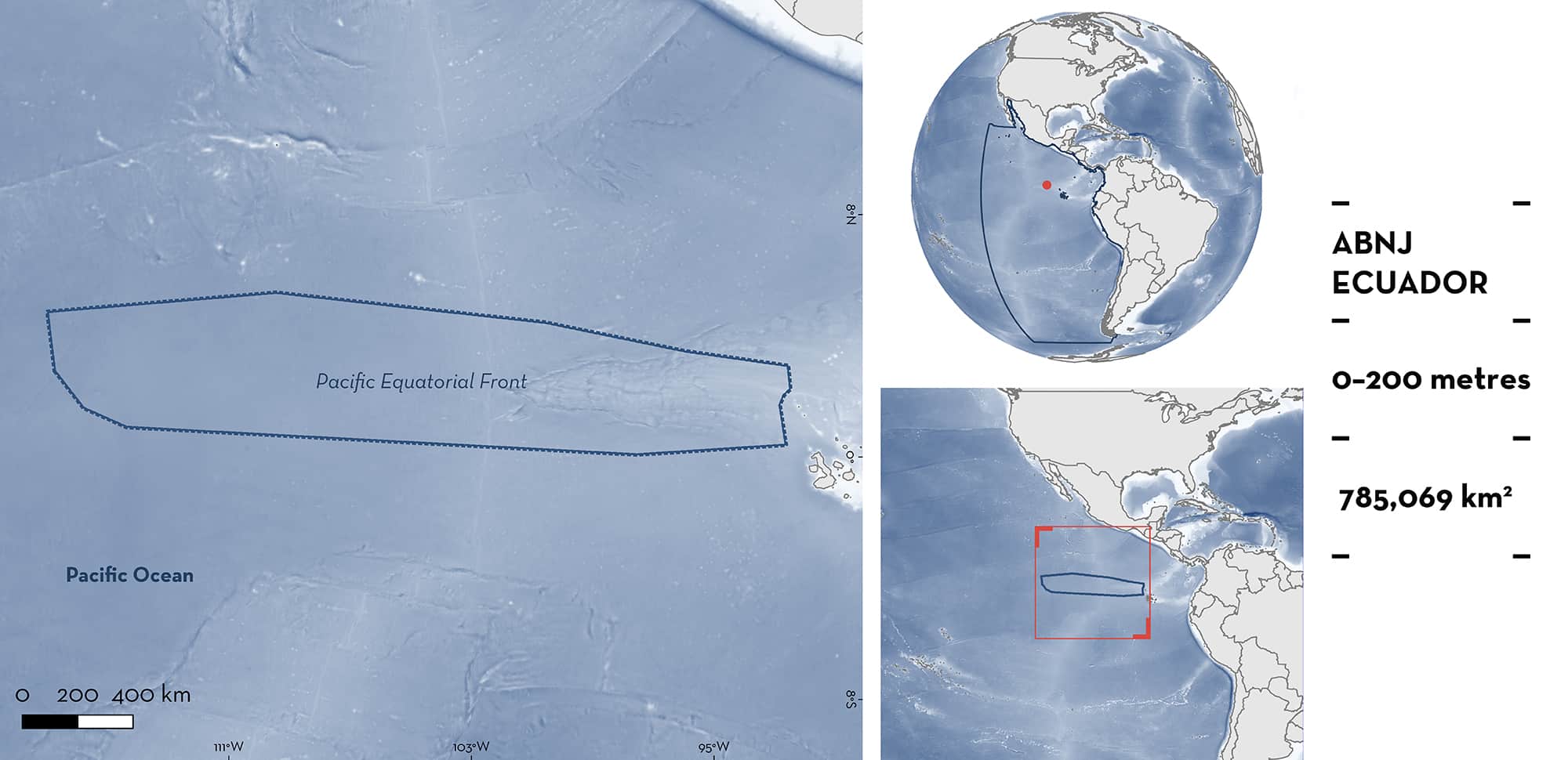
The Pacific Equatorial Front is located in the Eastern Tropical Pacific. It is an oceanic area mostly in areas beyond national jurisdiction (ABNJ), although the eastern portion is within the Ecuadorian Galápagos Exclusive Economic Zone. The area overlaps with an Ecologically or Biologically Significant Marine Area, the Equatorial High Productivity Zone. The area includes the boundary of the South Equatorial Current containing a strong temperature gradient and tropical instability waves that propagate along the front, concentrating plankton. Habitats include planktonic-rich oceanic waters oceanic and planktonic-rich pelagic waters. Within this area there are: threatened species; feeding areas; and areas important for movement (Whale Shark Rhincodon typus).
Download factsheet
Pacific Equatorial Front
DESCRIPTION OF HABITAT
The Pacific Equatorial Front is located in the Eastern Tropical Pacific and overlaps with an Ecologically or Biologically Significant Marine Area (EBSA), the Equatorial High Productivity Zone. It encompasses an equatorial front which is a hydrographical feature formed at the boundary between a band of cold, high salinity equatorial surface water in the south and warmer, fresher tropical surface water towards the north (Fiedler and Talley 2006). The Equatorial Front is one of the most prominent semi-permanent oceanographic features on the planet. It spans almost a quarter of the equatorial circumference and generates over a quarter of global new primary production (Ryan et al. 2017). As the cool South Equatorial Current moves westwards, shearing with the North Equatorial Countercurrent generates tropical instability waves that propagate along the front. The northern boundary of the South Equatorial Current varies from 2° to 5°N depending on the season (Spear et al. 2001). The Equatorial Front is an area with a strong north-to-south temperature gradient, and is the most developed gradient in the Eastern Tropical Pacific. The tropical instability waves aggregate plankton with the front at its strongest from July through to the end of the year (Spear et al. 2001).
This Important Shark and Ray Area is delineated from surface waters to a depth of 200 m, covering the epipelagic zone in which most of the high abundances of zooplankton, a key resource of the Whale Shark, are entrained (Spear et al. 2001).
CRITERION A
VULNERABILITY
The one Qualifying Species within the area is considered threatened with extinction according to the IUCN Red List of Threatened SpeciesTM. The Whale Shark is assessed as Endangered (Pierce and Norman 2016).
CRITERION C
SUB-CRITERION C2 – FEEDING AREAS
The Pacific Equatorial Front is an important feeding area for the Whale Shark. The tropical instability waves that propagate along this area concentrate plankton which are tracked seasonally by Whale Sharks from July to October. Adult female Whale Sharks appear at Darwin Island (Galápagos Marine Reserve) in July, but only remain there for 1–2 days before moving westwards along the front for up to 3,000 km (median = 1,296 km). They then return along the same area, passing near Darwin Island before moving towards the shelf break of mainland Ecuador and northern Peru by the end of the year (Hearn et al. 2016, 2017). While in the area, Whale Sharks appear to track inside the tropical instability waves, oceanographic features that concentrate zooplankton (Ryan et al. 2017). While no direct observations of feeding have been observed (due to the area’s remoteness), multiple lines of evidence suggest this is the area’s function. This includes: 1) repeated movements are observed during the same season over multiple years (Hearn et al. 2016, 2017, 2021) coinciding with the peak in Equatorial Front strength and zooplankton concentration (Spear et al. 2001; Ryan et al. 2017); 2) Whale Sharks are known to forage when zooplankton concentrations are high (Whitehead et al. 2020; Guzman et al. 2022); 3) almost all observations have been of large female Whale Sharks with high energy requirements (Lawson et al. 2019); and 4) seabirds and cetaceans have also been observed feeding on plankton in the same area (Spear et al. 2001; Ballance et al. 2006).
CRITERION C
SUB-CRITERION C4 – MOVEMENT
The Pacific Equatorial Front is an important movement area for the Whale Shark. Within the area, over 50 tracked adult female Whale Sharks have been recorded moving along the Equatorial Front predictably from July through October over multiple years (Hearn et al. 2016, 2017), tracking the tropical instability waves (Ryan et al. 2017). Individuals migrate west from the Galápagos Islands along the front before returning through the same area back past the Galápagos Islands and on towards mainland Ecuador and Peru (Hearn et al. 2021).
Download factsheet
SUBMIT A REQUEST
ISRA SPATIAL LAYER REQUEST
To make a request to download the ISRA Layer in either a GIS compatible Shapefile (.shp) or Google Earth compatible Keyhole Markup Language Zipped file (.kmz) please complete the following form. We will review your request and send the download details to you. We will endeavor to send you the requested files as soon as we can. However, please note that this is not an automated process, and before requests are responded to, they undergo internal review and authorization. As such, requests normally take 5–10 working days to process.
Should you have questions about the data or process, please do not hesitate to contact us.


