ISRA FACTSHEETS
ISRA FACTSHEETS
CENTRAL AND SOUTH AMERICAN PACIFIC REGION
Los Cóbanos-Acajutla
Summary
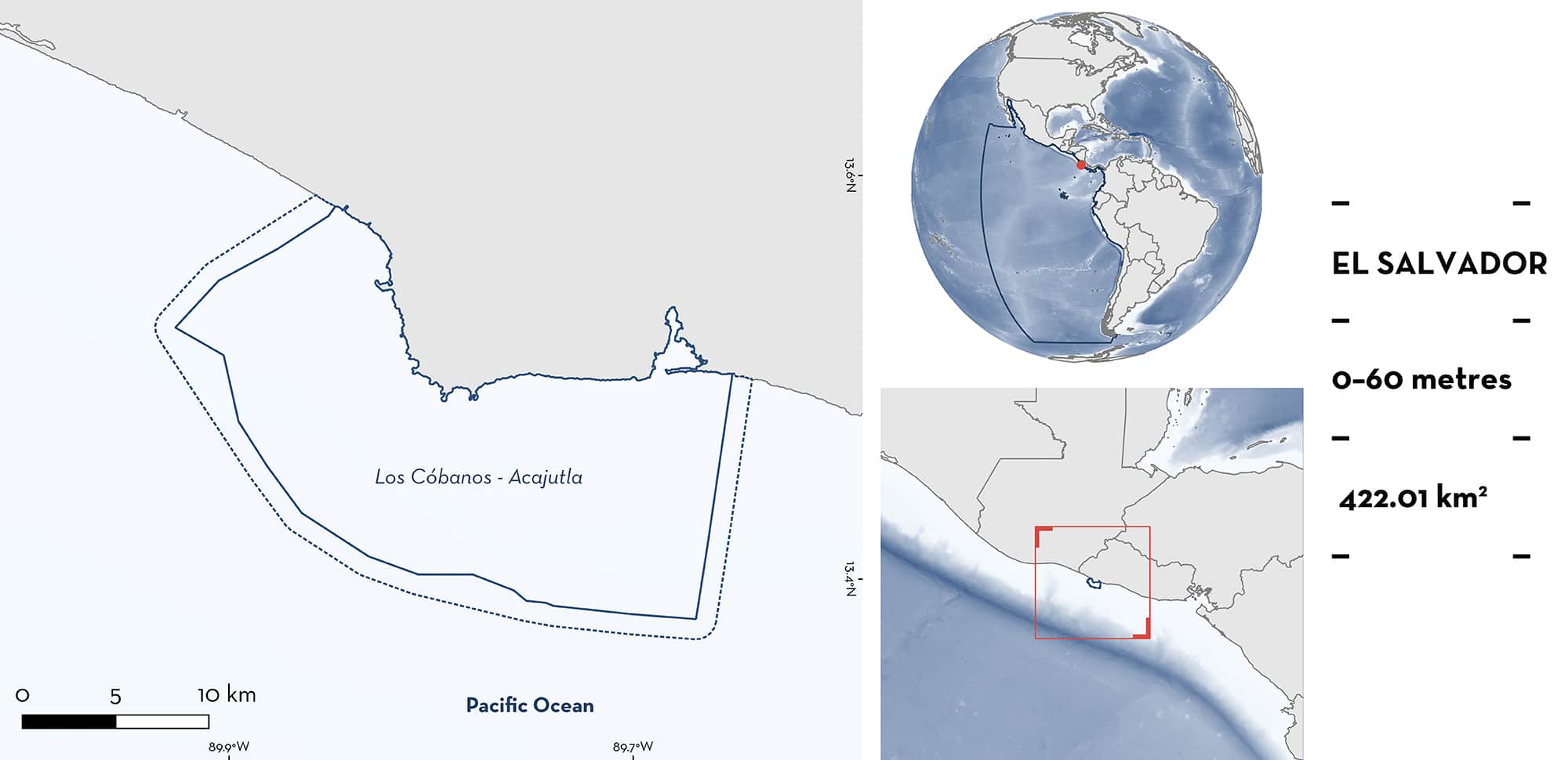
Los Cóbanos-Acajutla is located in El Salvador, adjacent to the villages of Acajutla and Los Cóbanos. This area includes the coastal Wetland of International Important (Ramsar site) Complejo los Cobános. The area is unique to the region as the only patch of coastal coral reef habitat from Costa Rica to Baja California. The area is also characterised by other habitats including volcanic beaches, mangroves, and estuaries. Within this area there are: threatened species and reproductive areas (Scalloped Hammerhead Sphyrna lewini).
Download factsheet
Los Cóbanos-Acajutla
DESCRIPTION OF HABITAT
Los Cóbanos-Acajutla is located in the Acajutla and Sonsonate municipalities of El Salvador, adjacent to the villages of Acajutla and Los Cóbanos. This area encompasses the Complejo Los Cóbanos Wetland of International Importance (Ramsar site) on the southwest part of El Salvador and the Acajutla area to the westward part. Situated within the Pacific Central-American Coastal Large Marine Ecosystem, there are two rivers, Sensunapan and Banderas, that merge with the Pacific Ocean on the northwest and east sides of the area. Both rivers discharge large loads of sediment and organic matter, and many small estuaries are associated with this zone. Littoral fringes include rocky and sandy shores while subtidal habitats include boulders as well as sandy and muddy patches (Arrivillaga 2009). Subtidal coral colonies exist from 0.5–3 m, where the dominant species is Lobe Coral Porites lobata. There are also small colonies of Psammocora spp. that cover an area of 0.5–1 km2. In deeper waters, there is abundant coverage of soft corals including Carijoa spp. as well as more than ten gorgonid species.
This Important Shark and Ray Area is delineated taking into consideration the extent of the Complejo Los Cobános Ramsar site, along with the reach of artisanal fisheries from Acajutla harbour (9 km from the harbour and 5.5 to 9 km from the coast, i.e., the area of most productivity; González Leiva et al. 2017). The area is delineated from inshore and surface waters (0 m) to the maximum depth of the area at 60 m.
CRITERION A
VULNERABILITY
One Qualifying Species considered threatened with extinction according to the IUCN Red List of Threatened SpeciesTM regularly occurs in the area, the Critically Endangered Scalloped Hammerhead (Rigby et al. 2020)
CRITERION C
SUB-CRITERION C1 – REPRODUCTIVE AREAS
Los Cóbanos-Acajutla is an important reproductive area for one shark species.
Landing surveys at three artisanal harbours between September 2015 and August 2016 recorded 578 Scalloped Hammerhead ranging from 30 to 330 cm total length (TL). However, 94% of individuals were < 100 cm TL and assessment of sexual maturity revealed 97% of Scalloped Hammerhead were immature, with ~80% classed as neonates. While catch was pooled among harbours, Puerto de Acajutla is reported as the most important landing site of those surveyed (González Leiva et al. 2017).
Download factsheet
SUBMIT A REQUEST
ISRA SPATIAL LAYER REQUEST
To make a request to download the ISRA Layer in either a GIS compatible Shapefile (.shp) or Google Earth compatible Keyhole Markup Language Zipped file (.kmz) please complete the following form. We will review your request and send the download details to you. We will endeavor to send you the requested files as soon as we can. However, please note that this is not an automated process, and before requests are responded to, they undergo internal review and authorization. As such, requests normally take 5–10 working days to process.
Should you have questions about the data or process, please do not hesitate to contact us.


