ISRA FACTSHEETS
ISRA FACTSHEETS
MEDITERRANEAN AND BLACK SEAS REGION
Murcia Pockmarks
Summary
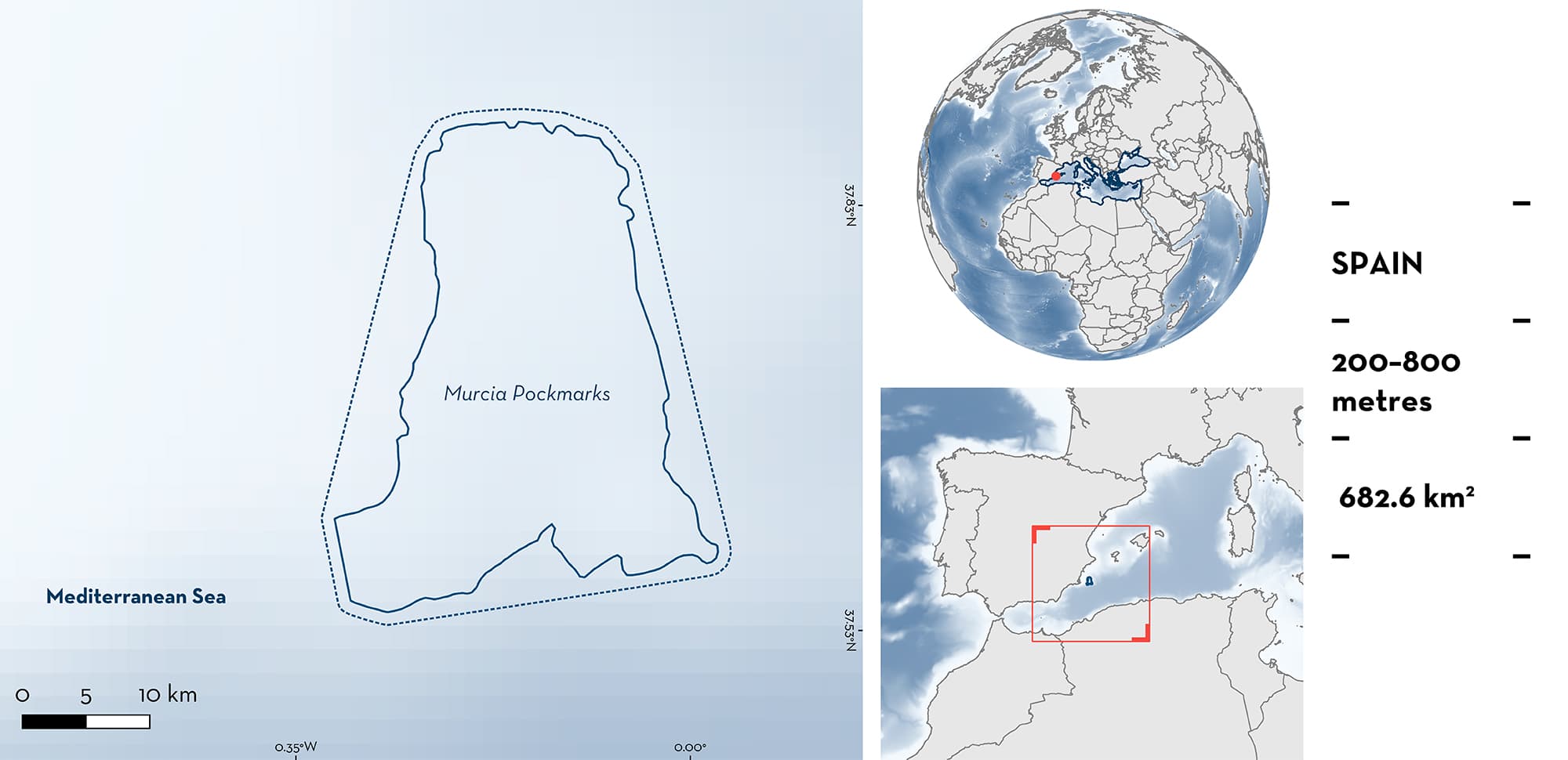
Murcia Pockmarks is located in a transition zone between the Alboran Sea and the Algerian-Balearic basin in the western Mediterranean Sea. It includes the seamount of Seco de Palos, the knolls Planazo and Plis-Plas, and a muddy field of pockmarks created by the expulsion of gas and water. It is characterised by habitats that are considered Vulnerable Marine Ecosystems, including sponges (Demospongiae), gorgonian assemblages, yellow tree coral, sea-pen fields, and bamboo coral gardens. This area overlaps with the North-western Mediterranean Benthic Ecosystems Ecologically or Biologically Significant Marine Area. Within the area there are: threatened species (Velbet Belly Lanternshark Etmopterus spinax); range-restricted species (Starry Skate Raja asterias); and reproductive areas (Velbet Belly Lanternshark).
Download factsheet
Murcia Pockmarks
DESCRIPTION OF HABITAT
Murcia Pockmarks is located in a transition zone between the Alborán Sea and the Algerian-Balearic basin off the coast of southeastern Iberian Peninsula in Spain (western Mediterranean Sea). Oceanographically, the area represents a connectivity zone between the Alborán and Balearic Seas, where Atlantic and Mediterranean waters converge, forming an anticyclonic eddy through the Cabo de Palos-Cabo Ténés oceanographic front (Ojeda et al. 2022). This area includes the seamount of Seco de Palos, the knolls Planazo and Plis-Plas, and a muddy field of pockmarks created by the expulsion of gas and water. Submarine canyons create upwelling events that result in a rich benthic community that includes large sponges (Demospongiae; e.g., Pachastrella spp., Phakellia spp., Poecillastra spp.), gorgonian assemblages (Bebryce spp., Swiftia spp., Nicella spp., Paramuricea spp., Acanthogorgia spp., Placogorgia spp.), cold-water white corals (genera Desmophyllum and Madrepora), and Yellow Coral (Dendrophyllia cornigera) on hard substrates, and sea-pen fields and bamboo coral gardens (Isidella elongata) on muddy substrates (Rossi et al. 2014; Cobo-Viveros et al. 2022; Ramos et al. 2022).
Reefs and pockmarks are considered key-priority habitats by the European Habitats Directive (92/43/ECC). Most of these benthic communities are considered Vulnerable Marine Ecosystems and Essential Fish Habitat by the Food and Agriculture Organization of the United Nations. Several habitat-building species protected by the Barcelona Convention of the Mediterranean Action Plan in the context of the Regional Seas Programme of the United Nations Environment Programme (UNEP-MAP) are found in the area like White Gorgonian (Callogorgia verticillata), Black Coral (Savalia savaglia), and Yellow Coral.
This area is within an Ecologically or Biologically Significant Marine Area (EBSA), the North-western Mediterranean Benthic Ecosystems EBSA (CBD 2023).
This Important Shark and Ray Area is benthopelagic from 300 to 800 m depth, based on the bathymetry of the area and the spatial distribution of key habitats, such as seamounts and the field of pockmarks.
CRITERION A
VULNERABILITY
One Qualifying Species within the area is considered threatened with extinction according to the IUCN Red List of Threatened SpeciesTM. The Velvet Belly Lanternshark is assessed as Vulnerable (Finucci et al. 2021).
CRITERION B
RANGE RESTRICTED
This area holds the regular presence of the Starry Skate as a resident range-restricted species. This species has been encountered yearly from 2002 to 2017 (except for 2004), being found in 17.2% of scientific benthic trawls in the area through the Mediterranean International Trawl Survey (MEDITS) (Arroyo et al. 2020). This area also overlaps with the highest abundance (24 individuals/km2) of this species in the Spanish western Mediterranean Sea (from Cap Creus to Cabo de Palos) according to MEDITS data collected between 2002–2012 during the early boreal summer period (May–July) (Giménez et al. 2020). Starry Skate is distributed primarily in the Mediterranean Sea Large Marine Ecosystem (LME) and only very marginally in the Canary Current LME and Iberian Coastal LME.
CRITERION C
SUB-CRITERION C1 – REPRODUCTIVE AREAS
Murcia Pockmarks is an important reproductive area for one shark species. A total of 148 Velvet Belly Lanternsharks were caught in MEDITS trawls with 73 of them captured since 2010 (Arroyo et al. 2020). The mean estimated size over the whole dataset was 18 ± 5 cm total length (TL), with a range of 11–29 cm TL. Over 60% of specimens were close to the size-at-birth (8–14 cm TL) (Marano et al. 2000), indicating that this area is important for neonates and young-of-the-year, as the regular presence of this life-stage has been recorded over multiple years (1994–2017). This area also overlaps with one of the highest abundances (12 individuals/km2) of this species in the Spanish western Mediterranean Sea (from Cap Creus to Cabo de Palos) according to MEDITS data collected between 2002–2012 during the early summer period (May–July) (Giménez et al. 2020).
Download factsheet
SUBMIT A REQUEST
ISRA SPATIAL LAYER REQUEST
To make a request to download the ISRA Layer in either a GIS compatible Shapefile (.shp) or Google Earth compatible Keyhole Markup Language Zipped file (.kmz) please complete the following form. We will review your request and send the download details to you. We will endeavor to send you the requested files as soon as we can. However, please note that this is not an automated process, and before requests are responded to, they undergo internal review and authorization. As such, requests normally take 5–10 working days to process.
Should you have questions about the data or process, please do not hesitate to contact us.


