ISRA FACTSHEETS
ISRA FACTSHEETS
WESTERN INDIAN OCEAN REGION
Boubyan Island and Adjacent Rivers
Summary
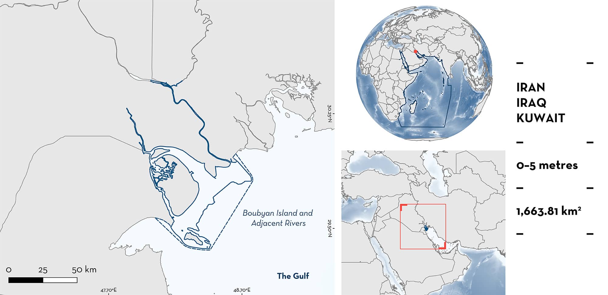
Boubyan Island & Adjacent Rivers is situated at the head of the Persian/Arabian Gulf, in the Tigris-Euphrates-Karun delta. This area falls within the Kuwaiti, Iraqi, and Iranian Exclusive Economic Zones. It is influenced by the Tigris and Euphrates Rivers, which form a confluence and discharges into the Persian/Arabian Gulf. This subtropical estuarine environment is characterised by intertidal mud, sand, and salt flat habitats. The area overlaps with two Key Biodiversity Areas, an Ecologically or Biologically Significant Marine Area, a Ramsar Site (Wetland of International Importance), and a Marine Reserve. Within this area there are: threatened species and reproductive areas (Bull Shark Carcharhinus leucas).
Download factsheet
Boubyan Island and Adjacent Rivers
DESCRIPTION OF HABITAT
Boubyan Island & Adjacent Rivers is situated at the head of the Persian/Arabian Gulf (hereafter referred to as ‘The Gulf’), in the Tigris-Euphrates-Karun delta. The area is influenced by the Tigris and Euphrates rivers that spans multiple jurisdictions. The two rivers join to form a confluence, and discharges in the Gulf. The area extends inland incorporating the estuarine systems alongside saltmarshes, to Nasiriyah, Iraq (>100 km from the coast). Boubyan Island is surrounded by subtropical estuarine environments characterised by intertidal mud, sand, and salt flats (Bishop et al. 2011). Alluvial sediment deposits are accumulated from river flows of the adjacent Shatt-al-Arab delta system (UNESCO 2017). Due to dynamic tidal processes and low-lying profile of the island, its terrestrial environments and interior sabhkas (coastal mudflats) are often flooded during high tides (Bishop et al. 2011; UNESCO 2017).
The area overlaps with two Key Biodiversity Areas: Fao and Khawr Abdallah (KBA 2023a, 2023b), the Shatt Al-Arab Delta Ecologically or Biologically Significant Marine Area (CBD 2023), the Mubarak Al-Kabeer Reserve Ramsar Site (Wetland of International Importance) (Ramsar 2023), and the Boubyan Island and Mubarak Al Kabeer Marine Reserve.
This Important Shark and Ray Area is benthopelagic and delineated from inshore and surface waters (0 m) to a depth of 5 m based on the bathymetry of the area.
CRITERION A
VULNERABILITY
The one Qualifying Species within the area is considered threatened with extinction according to the IUCN Red List of Threatened SpeciesTM. The Bull Shark is assessed as Vulnerable (Rigby et al. 2021).
CRITERION C
SUB-CRITERION C1 – REPRODUCTIVE AREAS
Boubyan Island & Adjacent Rivers is an important reproductive area for one shark species.
Bull Shark have been reported from the area as far back as the 1870s (Moore 2018), with historical records suggesting their presence in Iraq even further to the 2nd century (Moore & McDavitt 2009). Neonates, young-of-the-year (YOY), and juveniles make up the majority of these records estimated through comparison with the species from South Africa (size-at-birth in the area is estimated to be 75–83 cm total length [TL]; Moore 2018). There are also modern records that indicate the area is still important in supporting Bull Sharks at these life-stages. Forty-two individuals caught in this area were recorded in fish markets in Kuwait (26 in 2008 and 16 in 2011; Moore 2018). Of these, four individuals can be considered neonates based on their size (76–83 cm TL) and the presence of an umbilical scar, two could be considered YOY ranging from 90–99 cm TL, and a further 35 individuals could be considered juveniles ranging from 100–160 cm TL (size-at-maturity for females is estimated to be between 180 cm and 257 cm TL in the Western Indian Ocean; Moore et al. 2012; Jabado et al. 2016; Pirog et al. 2019). Bull Sharks use freshwater/estuarine environments as nursery areas, and this is one of few freshwater inputs/estuaries for ~9,000 km of northwest Indian Ocean coastline until East Africa. Female Bull Sharks normally give birth in these freshwater/estuarine systems, and the young remain for up to five years (Çiçek et al. 2023). The regional importance of this area is highlighted by this area being the only known location in the Gulf that supports Bull Sharks at early life-stages.
Download factsheet
SUBMIT A REQUEST
ISRA SPATIAL LAYER REQUEST
To make a request to download the ISRA Layer in either a GIS compatible Shapefile (.shp) or Google Earth compatible Keyhole Markup Language Zipped file (.kmz) please complete the following form. We will review your request and send the download details to you. We will endeavor to send you the requested files as soon as we can. However, please note that this is not an automated process, and before requests are responded to, they undergo internal review and authorization. As such, requests normally take 5–10 working days to process.
Should you have questions about the data or process, please do not hesitate to contact us.


