ISRA FACTSHEETS
ISRA FACTSHEETS
ASIA REGION
Fuji
Summary
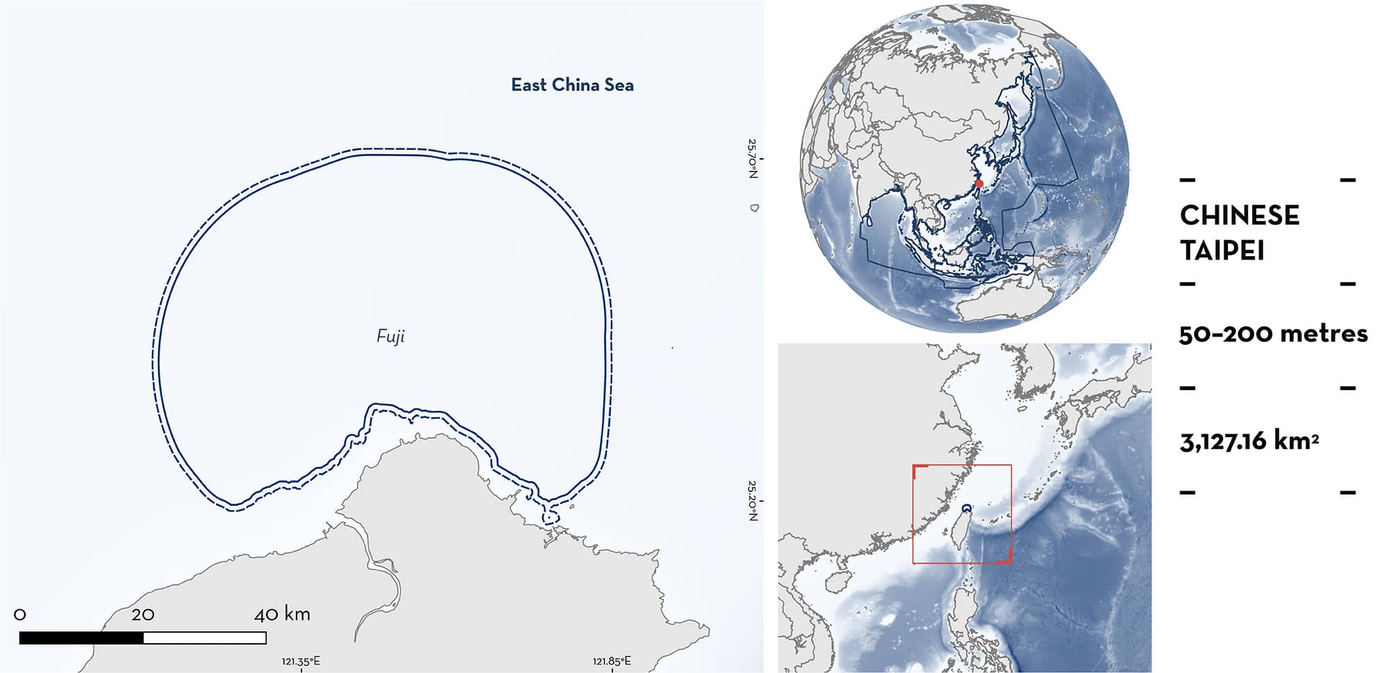
Fuji is located off the northern coast of Taiwan in the Northwest Pacific. The area lies on the continental shelf in the Taiwan Strait and is influenced by water moving through the Taiwan Strait into the Pacific. The habitat is characterised by sandy and silty substrates. Within this area there are: reproductive areas (Whitespotted Bambooshark Chiloscyllium plagiosum).
Download factsheet
Fuji
DESCRIPTION OF HABITAT
Fuji is located off northern Taiwan in the Northwest Pacific Ocean. This benthic and subsurface area lies on the continental shelf in the Taiwan Strait. The habitat is characterised by sandy and silty substrates, influenced by sediment input from large rivers in the region (Chen et al. 1988; Chen 2013), and rocky and gravel substrates nearer to the coast (Song et al. 1997).
In the Taiwan Strait, the current generally flows east- to northeastward into the Pacific (Tang et al. 2000). Kuroshio Current subsurface water encroaches onto the eastern shelf, creating a permanent upwelling centre (Chern & Wang 1990).
This Important Shark and Ray Area is benthic and subsurface and is delineated from 50 to 200 m.
CRITERION C
SUB-CRITERION C1 – REPRODUCTIVE AREAS
Fuji is an important reproductive area for one shark species.
Most specimens used in the studies from this area were caught in lobster/crab trap nets (Chen & Liu 2006; Chen et al. 2007). The main fishing area for crab trappers is on the shelf off northern Taiwan (the delineated area) where they target Coral Swimmer Crab Charybdis feriata, Ridged Swimming Crab C. natator, and Three-spot Swimming Crab Portunus sanguinolentus, in depths of 50–200 m (Chen 2013). A study undertaken between February 2002–2003 on the reproduction of Whitespotted Bamboosharks collected in Fuji showed a distinct annual reproductive cycle, with all stages occurring in this area (Chen & Liu 2006). The reproductive cycle of the species was examined through dissection of 173 males and 318 females, which showed that the species mates in December–January (Chen & Liu 2006). The corresponding seasonal variation in their sex ratio further suggested that mature males may seasonally migrate to the area to mate, with females otherwise dominating the count (Chen & Liu 2006; Chen et al. 2007). Almost half of the males and a quarter of females were mature (Chen & Liu 2006), which is higher compared to a study undertaken in Hong Kong that found 14% of males were mature (Sin 2009), suggesting that Fuji is an important mating area. Ovulation occurs in March–May, and they therefore store sperm for several months (Chen & Liu 2006). Eggs were deposited between April and May, with one or two eggs released every 6–7 days. Pups hatched after 107 days, between June–August, and have a size-at-birth of ~15 cm total length (TL). The species is abundant and regularly caught, but individuals <40 cm TL are rarely captured, perhaps because of the size-selective gear used (Chen & Liu 2006), but it is also possible that neonates and young-of-the-year live in shallower waters that were not surveyed (Chen et al. 2007). More recent work on 327 specimens collected in the area between October 2013 and March 2015 confirms that pregnant females still frequent this area and that females feed on active prey, such as cephalopods and fishes, before the mating and spawning season after which they feed more on polychaetes and sponges (Lin 2016). This suggests that females feed on higher energy prey before mating and spawning. The species is widely distributed around Taiwan, but it is less common outside the Fuji area (Liu 2006).
Download factsheet
SUBMIT A REQUEST
ISRA SPATIAL LAYER REQUEST
To make a request to download the ISRA Layer in either a GIS compatible Shapefile (.shp) or Google Earth compatible Keyhole Markup Language Zipped file (.kmz) please complete the following form. We will review your request and send the download details to you. We will endeavor to send you the requested files as soon as we can. However, please note that this is not an automated process, and before requests are responded to, they undergo internal review and authorization. As such, requests normally take 5–10 working days to process.
Should you have questions about the data or process, please do not hesitate to contact us.


