ISRA FACTSHEETS
ISRA FACTSHEETS
ASIA REGION
Pantar Strait
Summary
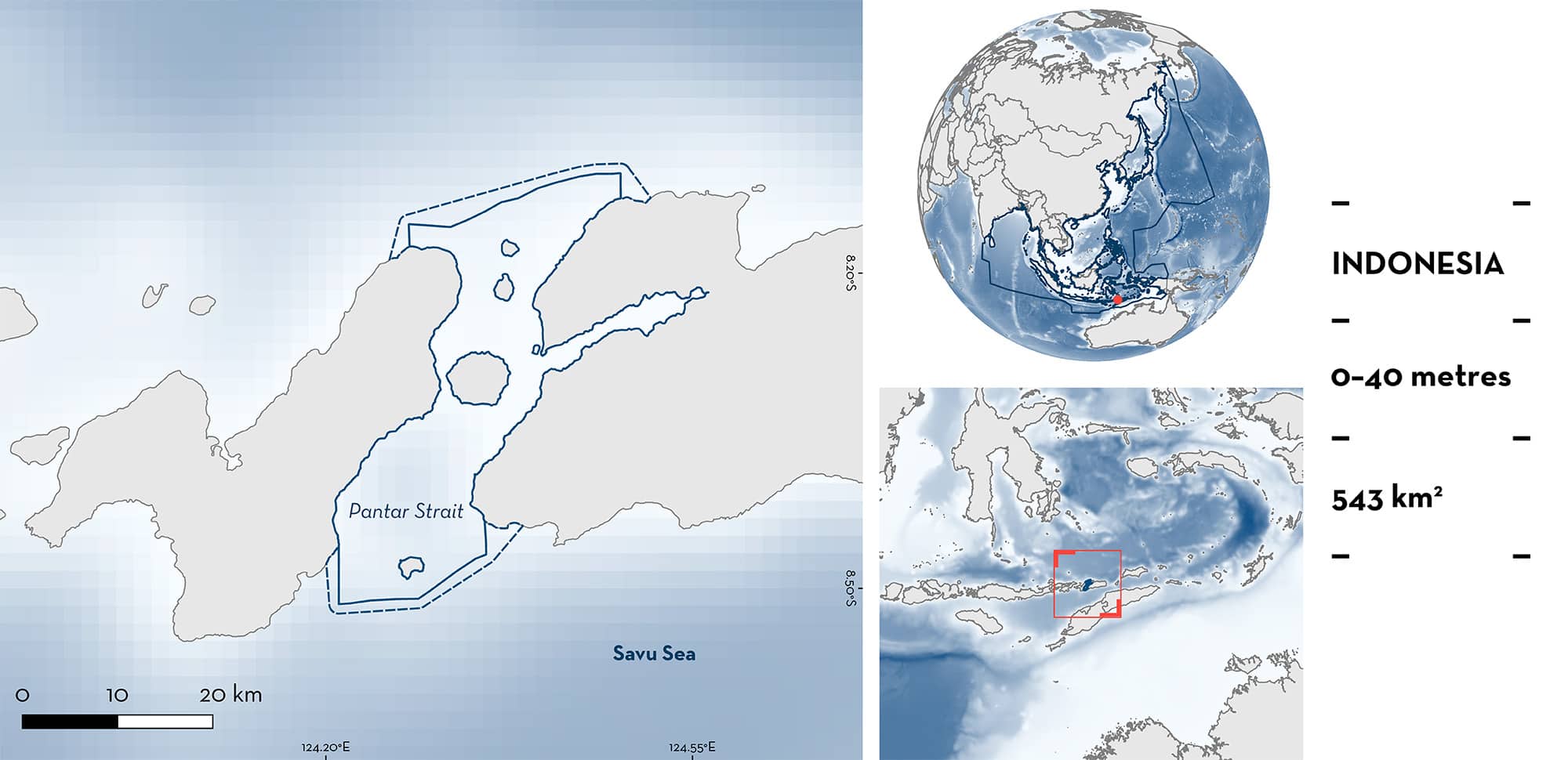
Pantar Strait is located in the eastern Lesser Sunda Islands, between Alor and Pantar islands, Indonesia. The area includes five small islands and is characterised by the presence of coral reefs, an extended continental shelf, and a small part of the slope. Pantar Strait overlaps with one marine protected area and with Perairan Gunung Muna Key Biodiversity Area. Within this area there are: threatened species (e.g., Scalloped Hammerhead Sphyrna lewini); reproductive areas (Pelagic Thresher Alopias pelagicus); and undefined aggregations (Scalloped Hammerhead).
Download factsheet
Pantar Strait
DESCRIPTION OF HABITAT
Pantar Strait is located in the eastern Lesser Sunda Islands, in the East Nusa Tenggara province of Indonesia. The Flores Sea lies to the north and the Savu Sea to the South (Wirasatriya et al. 2023). The strait is located between Alor and Pantar islands, the two largest islands of the Alor Archipelago, and includes five small islands: Buaya, Ternate, Pura, Kepa, and Tereweng. The area is characterised by the presence of coral reefs near the coasts of the islands, by an extended continental shelf, and by a small part of the slope in the southern and northern borders.
The area is influenced by the Indonesian Throughflow Current. This current flows through tight island clusters creating a strong and intricate current pattern with eddies and counter-eddies that concentrate nutrients. During the southeast (June–August) and northwest (December–February) monsoon seasons, coastal upwellings are common in the area (Wirasatriya et al. 2020) which interact with strong tidal dynamics and the bathymetry of the area to produce high tidal mixing (Wirasatriya et al. 2023).
The area overlaps with the Perairan Gunung Muna Key Biodiversity Area (KBA 2024) and with the Suaka Alam Perairan Selat Pantar Dan Perairan Sekitarnya Marine Nature Reserve.
This Important Shark and Ray Area is pelagic and is delineated from surface waters (0 m) to 40 m based on the depth range of the Qualifying Species in the area.
CRITERION A
VULNERABILITY
Two Qualifying Species considered threatened with extinction according to the IUCN Red List of Threatened Species regularly occur in the area. These are the Critically Endangered Scalloped Hammerhead (Rigby et al. 2019a) and the Endangered Pelagic Thresher (Rigby et al. 2019b).
CRITERION C
SUB-CRITERION C1 – REPRODUCTIVE AREAS
Pantar Strait is an important reproductive area for one shark species.
Local ecological knowledge indicates that fishers from Kalabahi Bay who operate in Pantar Strait, have been catching Pelagic Threshers for local consumption for >50 years (Shidqi et al. 2019). Currently, there are 20 active fishers, and according to them, Pelagic Threshers are caught from February to September, with a peak between March–May. Fisheries landings monitoring since 2018 showed that of 330 Pelagic Threshers sampled, 80% were pregnant females measuring between 270–330 cm total length (TL) with a large proportion containing near-term embryos (Shidqi et al. 2019). Neonates were not recorded in the area which is likely due to fishing gear selectivity. Areas with a high density of pregnant females with near-term embryos are little known for this species, highlighting the reproductive importance of the area.
CRITERION C
SUB-CRITERION C5 – UNDEFINED AGGREGATIONS
Pantar Strait is an important area for undefined aggregations of one shark species.
Pantar Strait is an up-and-coming dive destination in Indonesia. Since the early 2000s, dive operators in the area have reported the presence of Scalloped Hammerhead aggregations in March–May and in October–December at depths of 30–40 m. Since 2016, reports of these aggregations on social media have become increasingly common, and since 2019, observation efforts by multiple dive operators in the area have improved (AB Sianipar et al. unpubl. data 2023). The increase in diving operations around these aggregations has allowed them to confirm the regular presence of Scalloped Hammerheads in the area and their seasonality. Aggregations are usually composed of 3–50 individuals (AB Sianipar et al. unpubl. data 2023), and there are indications of the presence of a cleaning station for Scalloped Hammerheads in the area. More information is needed to confirm the nature and function of these aggregations.
Download factsheet
SUBMIT A REQUEST
ISRA SPATIAL LAYER REQUEST
To make a request to download the ISRA Layer in either a GIS compatible Shapefile (.shp) or Google Earth compatible Keyhole Markup Language Zipped file (.kmz) please complete the following form. We will review your request and send the download details to you. We will endeavor to send you the requested files as soon as we can. However, please note that this is not an automated process, and before requests are responded to, they undergo internal review and authorization. As such, requests normally take 5–10 working days to process.
Should you have questions about the data or process, please do not hesitate to contact us.


