ISRA FACTSHEETS
ISRA FACTSHEETS
ASIA REGION
Cenderawasih Bay
Summary
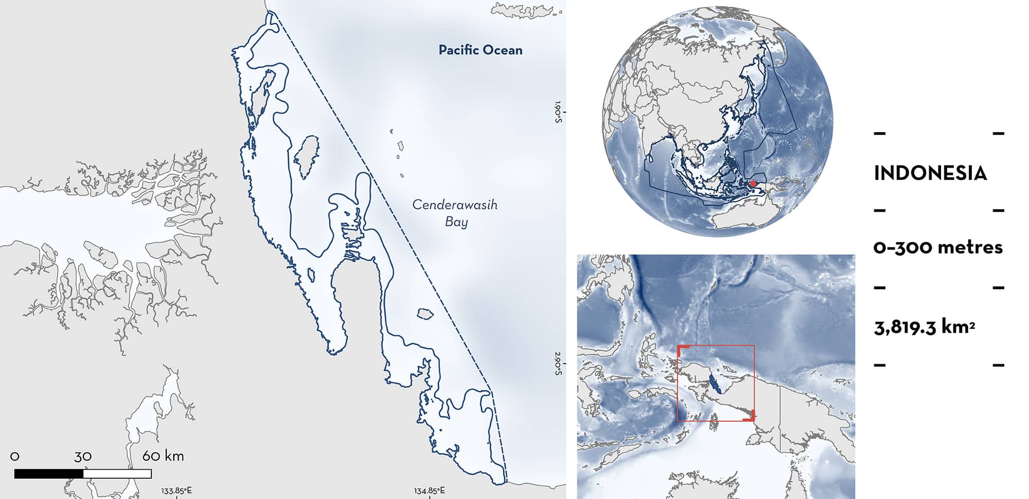
Cenderawasih Bay is located in West Papua, northeastern Indonesia. The area is a semi-enclosed embayment with large nutrient inputs from rivers. It is characterised by the presence of coral reefs, seagrass beds, and mangrove forests. Cenderawasih Bay is a high productivity area and is strongly influenced by monsoon seasons. The area overlaps with the Cenderawasih Bay National Park. Within the area there are: threatened species (e.g., Gale’s Epaulette Shark Hemiscyllium galei); range-restricted species (Gale’s Epaulette Shark); and feeding areas (Whale Shark Rhincodon typus).
Download factsheet
Cenderawasih Bay
DESCRIPTION OF HABITAT
Cenderawasih Bay is located in West Papua, northeastern Indonesia. The area is a semi-enclosed embayment with limited water exchange and large oceanic currents outside (Mangubhai et al. 2012). It is characterised by the presence of coral reefs, seagrass beds, and mangrove forests.
The area is strongly influenced by monsoon seasons, with the northwest monsoon (November to March) producing warmer sea surface temperature (SST), high precipitation, intermittent winds, and north swells. This area has the highest rainfall intensity in the world, with rivers flowing into the area providing continuous nutrients specially during March (Alfahmi et al. 2019). In contrast, the southeast monsoon (May to October) is characterised by colder SST, less rainfall, persistent winds, and strong southeast swells that produce an increase in productivity (Prentice & Hope 2007). Sea surface temperatures range from 29–31.3°C (Manuhutu et al. 2021; Meyers 2023).
The area overlaps with the Cenderawasih Bay National Park.
This Important Shark and Ray Area is benthopelagic and is delineated from inshore and surface waters (0 m) to 300 m based on the bathymetry of the area.
CRITERION A
VULNERABILITY
Two Qualifying Species considered threatened with extinction according to the IUCN Red List of Threatened Species regularly occur in the area. These are the Endangered Whale Shark (Pierce & Norman 2016) and the Vulnerable Gale’s Epaulette Shark (VanderWright et al. 2021).
CRITERION B
RANGE RESTRICTED
This area holds the regular presence of Gale’s Epaulette Shark as a resident range-restricted species. This species is endemic to Cenderawasih Bay and has not been reported in any other location in the world. It has been regularly reported in the area since 2007 from diving observations with many individuals sampled for taxonomic studies (Allen & Erdmann 2008; Allen et al. 2016; Dudgeon et al. 2020; MV Erdmann unpubl. data. 2023). Between 2–13 individuals were recorded on every one of the 40+ nocturnal dive surveys conducted between 2007–2023 (MV Erdmann unpubl. data. 2023). Gale’s Epaulette Shark is a demersal shark found in shallow rocky outcrops, coral reefs, and seagrass beds at depths of 0–10 m with one individual recorded from 25 m (Allen et al. 2016). The shark occurs on the coral reef habitat around the bay which is concentrated from the southwest to northwest sides of the bay, from Manokwari to Nabire. These reef areas are flanked by big river mouths that produce stretches of inappropriate soft substrate and mangrove habitats that has likely been limiting their further dispersal in the region (Allen et al. 2016).
CRITERION C
SUB-CRITERION C2 – FEEDING AREAS
Cenderawasih Bay is an important feeding area for one shark species.
Whale Shark aggregations are commonly seen in the area. Photos of Whale Sharks collected since 2010 have allowed the identification of more than 150 individuals that have been observed year-round with a peak from January to March and October (Ranintyari et al. 2018; Meyers et al. 2020; Manuhutu et al. 2021; Konservasi Indonesia unpubl. data 2023). Most individuals are juveniles or sub-adults with a strong male bias (~90% of individuals) and an average size of 444 ± 178 cm total length (TL; Himawan et al. 2015; Konservasi Indonesia unpubl. data 2023).
Whale Shark aggregations are commonly observed around bagan liftnet fisheries operating around Kwatisore Peninsula, in the southwest coast of the area as well as off the large river mouths in the bays of Teluk Umar and Teluk Wondama in the central western coast of Cendrawasih Bay. Animals in these aggregations are commonly seen feeding on the clupeid and atherinid fishes that the fishers are targeting (Meyers et al. 2020). Whale Sharks do however, feed on a wider diverse of prey from zooplankton to other small fishes. More than 50 village elders interviewed have reported that Whale Sharks were observed chasing and feeding on baitfish in the area long before the fishery started in 2003 (Konservasi Indonesia unpubl. data 2023). Anchovies are the main species in bagan fisheries and have higher abundance in the same months when aggregations of Whale Shark peak that also coincides with higher productivity in the area influenced by intense rainfall and river discharges (Ihsan et al. 2018; Alianto & Hamuna 2020; Manuhutu et al. 2021).
A recent study using biologgers revealed that besides the baitfish Whale Sharks target around the bagan, they also feed on other prey in shallow waters and deeper oceanic sites in Cenderawasih Bay (AB Sianipar et al. unpubl. data 2023). In addition, satellite telemetry has shown that individuals tagged (n = 35) since 2015 have a high-fidelity to the area where they spend ~82% of the year (Meyers 2023; AB Sianipar et al. unpubl. data 2023) .
Download factsheet
SUBMIT A REQUEST
ISRA SPATIAL LAYER REQUEST
To make a request to download the ISRA Layer in either a GIS compatible Shapefile (.shp) or Google Earth compatible Keyhole Markup Language Zipped file (.kmz) please complete the following form. We will review your request and send the download details to you. We will endeavor to send you the requested files as soon as we can. However, please note that this is not an automated process, and before requests are responded to, they undergo internal review and authorization. As such, requests normally take 5–10 working days to process.
Should you have questions about the data or process, please do not hesitate to contact us.


