ISRA FACTSHEETS
ISRA FACTSHEETS
ASIA REGION
Sarmi-Jayapura
Summary
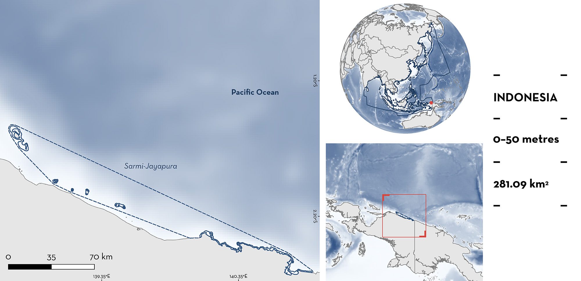
Sarmi-Jayapura is located in Papua, Indonesia near the border with Papua New Guinea. The area includes multiple islands and islets, and is characterised by coral reefs. It is influenced by freshwater input and monsoons. The area overlaps with the KKPD Teluk Depapre marine protected area. Within this area there are: threatened species and range-restricted species (Hooded Carpetshark Hemiscyllium strahani).
Download factsheet
Sarmi-Jayapura
DESCRIPTION OF HABITAT
Sarmi-Jayapura is located on the northern coast of New Guinea in Papua, Indonesia. It sits within the Bird’s Head Seascape, recognised as a global hotspot of coral reef biodiversity and marine megafauna (Allen & Erdmann 2024). The area includes the offshore fringing reefs of the Kumamba and Podena Island groups (consisting of three and four islands, respectively) just to the southeast of the Mamberamo River outlet and an ~100 km stretch of rugged coastline from Matterer Bay eastwards to Jayapura’s Yos Sudarso Bay, including Depapre Bay. The high outflow of freshwater from the Mamberamo River prevents reef development along the coastline for nearly 250 km, with reef development beginning around Matterer Bay and stretching eastwards (M Erdmann pers. obs. 2019). However, there are coral reefs and seagrass beds around the offshore islands of the Kumamba and Podena Island groups. The coastline from Matterer Bay east to Yos Sudarso Bay has an extended shelf characterised by the presence of coral reefs, mangroves, and seagrass beds. Depapre Bay in particular has extensive patch reefs and fringing coral reefs around each of the islands there.
The area is mainly influenced by monsoon seasons. The northwest monsoon (November to April) is characterised by warm sea surface temperatures. In contrast, the southeast monsoon (May to October) is characterised by strong and continuous southeast winds that produce upwellings, resulting in an increase in primary productivity in coastal areas (Mangubhai et al. 2012).
The area overlaps with the KKPD Teluk Depapre marine protected area (Paulangan et al. 2021).
This Important Shark and Ray Area is benthic and delineated from inshore and surface waters (0 m) to a depth of 50 m based on the bathymetry of the area.
CRITERION A
VULNERABILITY
One Qualifying Species within the area is considered threatened with extinction according to the IUCN Red List of Threatened Species. The Hooded Carpetshark is listed as Vulnerable (VanderWright et al. 2021).
CRITERION B
RANGE RESTRICTED
This area holds the regular presence of Hooded Carpetshark as a resident range-restricted species. This species was recorded in the area during two scientific surveys in 2013 and 2019 (Allen et al. 2016; VanderWright et al. 2022). It has also been seen regularly on the reefs of Depapre Bay and Yos Sudarso Bay from 2000–2024 by recreational divers from Jayapura City (M Ammer pers. comm. 2024). The survey in 2013 collected genetic samples from six individuals during a one-hour night dive in Depapre Bay (Dudgeon et al. 2020), while the survey in 2019 recorded 15 individuals, including three females carrying egg cases, in a three-hour night snorkel in Depapre Bay (M Erdmann unpubl. data 2019). For the offshore islands of the Kumamba and Podena Island groups, the species was reported from artisanal fisher landings in 2017 and 2018 (P Seery pers. comm. 2018), followed by vessel-based survey of the area in 2019. During this survey, six islands were visited, and confirmed the presence of the species by direct observation on night snorkels at Liki and Armo Islands (one individual recorded from each site) and through interviews with 14 fishers at the four islands of the Podena group. Fishers of the Podena group observe Hooded Carpetshark every night and have likely seen several hundreds of individuals during their lifetime. Fishers indicated the species is always found on reefs flats and seabeds around the Podena Islands (MV Erdmann unpubl. data 2024).
Although the home range of Hooded Carpetsharks has not been formally investigated, it is believed that all nine species of Hemiscyllium have extremely small home range sizes and most individuals likely live, feed, mate, and lay eggs on the same reef where they hatched. Numerous anecdotal observations of Gale’s Epaulette Shark Hemiscyllium galei, Henry’s Epaulette Shark Hemiscyllium henryi, and Raja Ampat Epaulette Shark Hemiscyllium freycineti from 2007–2024 suggest that individuals rarely range more than several hundred square metres over a period of months (Allen et al. 2016; Dudgeon et al. 2020; VanderWright et al. 2022; MV Erdmann unpubl. data 2020; E Setyawan unpubl. data 2024).
Hooded Carpetshark has the smallest area of occurrence of any of the Hemiscyllium species, with only 720 km2 of suitable habitat along the coast of northern Papua and Papua New Guinea (VanderWright et al. 2022). Sarmi-Jayapura is one of only two known locations where the regular presence of this species has been recorded (the other is the reef flats of the Madang area of Papua New Guinea, over 700 km to the southeast) (Allen et al. 2016). Given the rarity of sightings and landings data for this species, Sarmi-Jayapura is considered an important area for this range-restricted species, which is endemic to Indonesia and Papua New Guinea, and occurs only in the Indonesian Sea Large Marine Ecosystem.
Download factsheet
SUBMIT A REQUEST
ISRA SPATIAL LAYER REQUEST
To make a request to download the ISRA Layer in either a GIS compatible Shapefile (.shp) or Google Earth compatible Keyhole Markup Language Zipped file (.kmz) please complete the following form. We will review your request and send the download details to you. We will endeavor to send you the requested files as soon as we can. However, please note that this is not an automated process, and before requests are responded to, they undergo internal review and authorization. As such, requests normally take 5–10 working days to process.
Should you have questions about the data or process, please do not hesitate to contact us.


