ISRA FACTSHEETS
ISRA FACTSHEETS
NEW ZEALAND & PACIFIC ISLANDS REGION
Poé
Summary
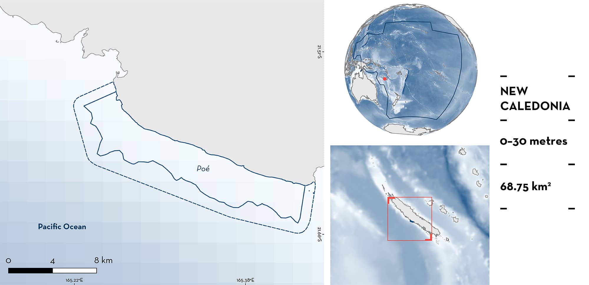
Poé is located on the western side of New Caledonia. It is a shallow lagoon surrounded by a barrier reef with extensive seagrass beds near the shore. It is bordered by a deep channel in the west and by Gouaro Bay in the east. It is characterised by sandy and hard substrates with algal beds and coral structures. Within this area there are: threatened species (e.g., Whitetip Reef Shark Triaenodon obesus) and undefined aggregations (e.g., Spotted Eagle Ray Aetobatus ocellatus).
Download factsheet
Poé
DESCRIPTION OF HABITAT
Poé is located on the central-western side of Grande Terre Island in New Caledonia. It is a shallow lagoon (~5 m) surrounded by a barrier reef on the outer side and extensive seagrass beds near the shore (Amrari et al. 2021; Heudier et al. 2023). On the western side it is bordered by the Faille aux Requins channel with depths up to 25 m, while on the eastern side it is bounded by Gouaro Bay (Amrari et al. 2021; Heudier et al. 2023). The lagoon is characterised by sandy substrates with algal beds, coral structures, and hard substrates (Amrari et al. 2021).
The area overlaps with the Poé Natural Reserve (IUCN 2024).
This Important Shark and Ray Area is benthic and pelagic and is delineated from inshore and surface waters (0 m) to 30 m based on the bathymetry of the area.
CRITERION A
VULNERABILITY
Two Qualifying Species considered threatened with extinction according to the IUCN Red List of Threatened Species regularly occur in the area. This is the Endangered Spotted Eagle Ray (Finucci et al. 2024) and the Vulnerable Whitetip Reef Shark (Simpfendorfer et al. 2020).
CRITERION C
SUB-CRITERION C5 – UNDEFINED AGGREGATIONS
Poé is an important area for undefined aggregations of one shark and one ray species.
Videos posted on social media in 2013, 2019, and 2020 highlight the regular occurrence of Whitetip Reef Shark aggregations (3–6 individuals). Between 1986–2014, distance-sampling visual census surveys (50 m long by 10 m wide at ~15 m depth) were conducted at 15 sites along New Caledonia with Poé holding the largest aggregations of Whitetip Reef Sharks (five individuals) among all sites (Juhel et al. 2017). In May 2019, 12 distance-sampling visual census surveys fixed-width transect surveys were conducted in the area and eight Whitetip Reef Sharks measuring 90–150 cm total length (TL) were observed in five of the stations surveyed (Wantiez et al. 2019). Animals appear to be resting together at this site, but more information is needed to confirm the nature and function of these aggregations.
Spotted Eagle Ray aggregations were reported in the area during four aerial surveys conducted between October–December 2014 (REMMOA 2024). This species was reported in the area from aerial surveys (36 days with a total of 42 hours of video recorded) conducted between September 2019 and January 2020 (Desgarnier et al. 2022). In these surveys, 314 encounters with at least one Spotted Eagle Ray were recorded, with multiple rays recorded in single encounters (Desgarnier et al. 2022). Additionally, during 20 days between July–November 2021, aerial surveys recorded 17 hours of video, with multiple individuals recorded in a single encounter (Heudier et al. 2023). In these surveys, eagle rays were not identified to the species level. Ornate Eagle Ray Aetomylaeus vespertilio also occur in New Caledonia. While the individuals observed in aerial surveys were categorised as ‘eagle rays’, the Spotted Eagle Ray is the most common species in New Caledonia and pictures from social media confirm its regular presence in the area and that recorded aggregations are of this species. Aggregations were observed near the deep channel in the western side of the area and in lagoon, barrier reef, and seagrass habitats in the east side of the area (Desgarnier et al. 2022; Heudier et al. 2023). Social media pictures from 2023 have revealed the presence of aggregations of Spotted Eagle Rays comprising between 3–12 individuals in the area. More information is needed to confirm the nature and function of these aggregations.
Download factsheet
SUBMIT A REQUEST
ISRA SPATIAL LAYER REQUEST
To make a request to download the ISRA Layer in either a GIS compatible Shapefile (.shp) or Google Earth compatible Keyhole Markup Language Zipped file (.kmz) please complete the following form. We will review your request and send the download details to you. We will endeavor to send you the requested files as soon as we can. However, please note that this is not an automated process, and before requests are responded to, they undergo internal review and authorization. As such, requests normally take 5–10 working days to process.
Should you have questions about the data or process, please do not hesitate to contact us.


