ISRA FACTSHEETS
ISRA FACTSHEETS
SOUTH AMERICAN INLAND WATERS
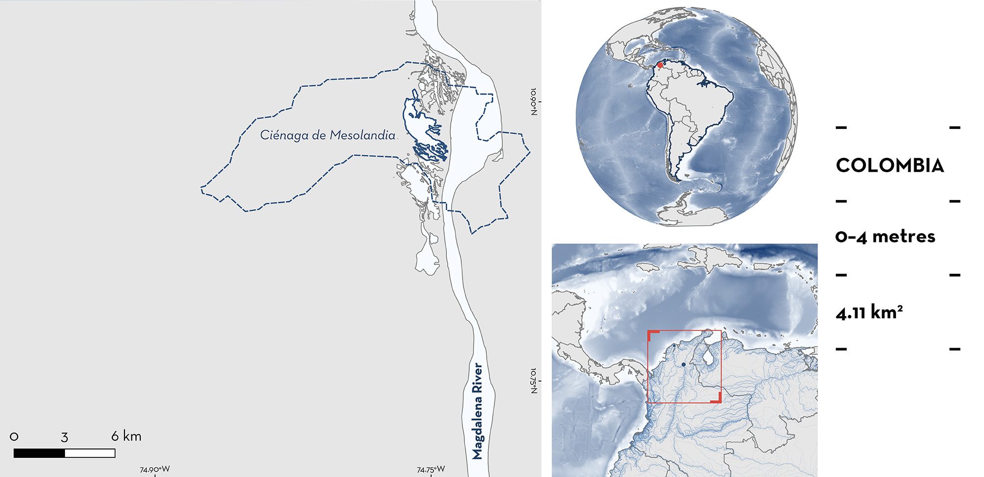
Ciénaga de Mesolandia
Summary
Ciénaga de Mesolandia is located in the lower Magdalena River basin, in northern Colombia. The area is a swamp connected to the Magdalena River. It is characterised by shallow, slow-moving waters with seasonal fluctuations in water levels due to rainfall, and muddy substrates. Within this area there are: range-restricted species and reproductive areas (Magdalena Freshwater Stingray Potamotrygon magdalenae).
Download factsheet
Ciénaga de Mesolandia
DESCRIPTION OF HABITAT
Ciénaga de Mesolandia is located in the lower Magdalena River, Department of Atlantico, in northern Colombia. The Magdalena River basin is the most important and extensive drainage system of the Andean-Caribbean region. The lower Magdalena River is characterised by an inland delta landscape with depressions flooded by a high-water table, dominated by lakes and swamps (Graca et al. 2025). The precipitation regime is bimodal, with two rainy seasons (December–March, July–August), and two dry seasons (April–June, October–November) with minimum average of 13 mm/month in the Lower Magdalena (Graca et al. 2025).
This area is a swamp located between the municipalities of Soledad and Malambo (Alean 2009); it is bordered to the east by the Magdalena River, to the west by the Mesolandia town, to the north it connects with the Soledad Canal, and to the south with the Malambo Swamp, through the Hondo Canal. The Magdalena River feeds directly into the Ciénaga de Mesolandia through a canal built in 1993 (Alean 2009). This area is characterised by shallow, slow-moving waters with seasonal fluctuations in water levels due to rainfall, with muddy substrates and soils rich in organic matter (Mejia-Falla et al. 2013). This area has an average depth of 1.73 m with a range between 0.74 and 3.1 m (Alean 2009).
The swamps located in the lower Magdalena basin present the shallowest depths (0.3–19.4 m) and the highest average bottom temperatures compared to the higher Magdalena basin (maximum depth of 60 m) (Mejia-Falla et al. 2013). The swamp’s vegetation of the lower Magdalena basin is characterised by the Common Water Hyacinth Eichhornia crassipes (Mejia-Falla et al. 2013).
This Important Shark and Ray Area is benthic and is delineated from surface waters (0 m) to 4 m based on the bathymetry of the area.
CRITERION B
RANGE RESTRICTED
This area holds the regular presence of the Magdalena Freshwater Stingray as a resident range-restricted species. This species occurs year-round in the area and is regularly encountered and caught in local fisheries as incidental catch and for ornamental purposes (Mejia-Falla et al. 2013). Between 2010–2013, along the Magdalena River basin, 150 fishers were interviewed across 24 locations, with 21 fishers interviewed in this area (Mejia-Falla et al. 2013, 2016). Most fishers specialising in a target fishery of Magdalena Freshwater Stingrays were located in this area (Mejia-Falla et al. 2013, 2016).
Between 2010–2013, captures of Magdalena Freshwater Stingrays were recorded in 75 fishery locations along the Magdalena River basin (lower, medium, and upper regions). The highest number of captures (336 of a total of 686) were in the lower Magdalena River, where this area is located. In the lower Magdalena River, the two most commonly used fishing gears to catch this species are the cast and trammel nets. The average number of rays captured per fishing set is 0.4 for the cast net and 2.2 for the trammel net, with maximum average captures of 4.2 and 3 animals, respectively (Mejia-Falla et al. 2013). Despite the species’ wide distribution along the rivers and tributaries, its fishing for the ornamental trade is restricted to a few bodies of water in the lower Magdalena River basin, such as the Ciénega de Mesolandia (Mejia-Falla et al. 2024).
Magdalena Freshwater Stingray is endemic to Colombia where it is restricted to three basins: Magdalena-Cauca basin including the Magdalena, Cauca, San Jorge rivers; Atrato basin composed of Atrato River; and Sinú basin composed of Sinú River (Mejia-Falla et al. 2024). The Magdalena Freshwater Stingray’s preferred habitat is muddy substrates in turbid, warm, and shallow waters, with currents of medium intensity, and with the presence of the Common Water Hyacinth, or without any type of vegetation on the surface (Mejia-Falla et al. 2013, 2024). There are also regular reports of this species at different life-stages within the area.
CRITERION C
SUB-CRITERION C1 – REPRODUCTIVE AREAS
Ciénaga de Mesolandia is an important reproductive area for one ray species.
Between 2010–2013, Magdalena Freshwater Stingrays (n = 484) were collected along the Magdalena River basin at 75 fishing sites (lower = 188, medium = 224, upper = 72) (Mejia-Falla et al. 2013, 2016). In the lower part of the basin, which includes this area, most animals captured (64.4%) were neonates (mode: 9 cm disc width [DW]), followed by young-of-the-year (YOY) and juveniles (24.4%, mode: 12.5 cm DW); adults in this part of the basin corresponded to 8% (mode: 17 cm DW) of catches (Mejia-Falla et al. 2013). The lower Magdalena River basin, including this area, has the highest proportion of neonates and YOY compared to the middle and upper sections (Mejia-Falla et al. 2013). In the lower Magdalena River, females mature at 17–24 cm DW and the size-at-birth of this species is 8.7–10 cm DW (Teshima & Takeshita 1992; Ramos-Socha & Grijalba-Bendeck 2011).
Download factsheet
SUBMIT A REQUEST
ISRA SPATIAL LAYER REQUEST
To make a request to download the ISRA Layer in either a GIS compatible Shapefile (.shp) or Google Earth compatible Keyhole Markup Language Zipped file (.kmz) please complete the following form. We will review your request and send the download details to you. We will endeavor to send you the requested files as soon as we can. However, please note that this is not an automated process, and before requests are responded to, they undergo internal review and authorization. As such, requests normally take 5–10 working days to process.
Should you have questions about the data or process, please do not hesitate to contact us.


