ISRA FACTSHEETS
ISRA FACTSHEETS
SOUTH AMERICAN ATLANTIC REGION
Abrolhos Bank
Summary
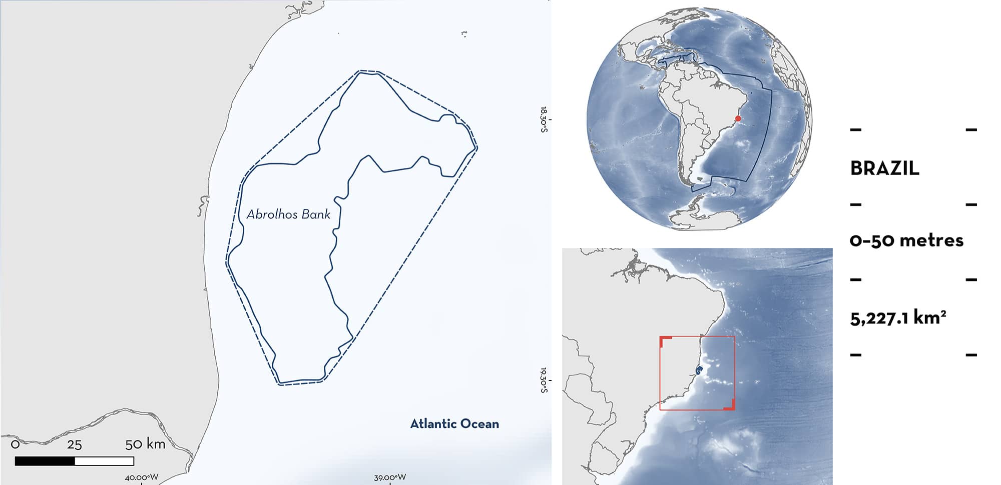
Abrolhos Bank is located in Brazil. It is situated off the coast of the states of Bahia and Espírito Santo on the continental shelf. This area is characterised by mangroves, seagrass, macroalgae, rhodolith beds, coralline reefs, and large extents of nearshore soft substrates. The area overlaps with the Abrolhos Bank and Vitória-Trindade Chain Ecologically or Biologically Significant Marine Area. Within this area there are: threatened species (e.g., Great Hammerhead Sphyrna mokarran); range-restricted species (Large-eye Stingray Hypanus marianae); and reproductive areas (e.g., Blacknose Shark Carcharhinus acronotus).
Download factsheet
Abrolhos Bank
DESCRIPTION OF HABITAT
Abrolhos Bank is located in Brazil. It is situated off the coast of the states of Bahia and Espírito Santo on the continental shelf. This area is characterised by mangroves, seagrass, macroalgae, rhodolith beds, coralline reefs, and large extents of nearshore soft substrates (Rolim et al. 2022). Abrolhos Bank is mainly influenced by the Brazil Current, which, along with tidal and wind-driven currents, creates oligotrophic conditions (Medeiros et al. 2022). South-southwestward currents occur from October to January, while north-northeastward currents dominate in austral fall and winter. The Rio Doce discharge creates a muddy deposit in the southern part of this area (Vinzon et al. 2024).
The area overlaps with the Abrolhos Bank and Vitória-Trindade Chain Ecologically or Biologically Significant Marine Area (EBSA; CBD 2025).
This Important Shark and Ray Area is benthic and pelagic and is delineated from surface waters (0 m) to 50 m based on the bathymetry of the area.
CRITERION A
VULNERABILITY
Three Qualifying Species considered threatened with extinction according to the IUCN Red List of Threatened Species regularly occur in the area. These are the Critically Endangered Great Hammerhead (Rigby et al. 2019); and the Endangered Blacknose Shark (Carlson et al. 2021) and Large-eye Stingray (Pollom et al. 2020).
CRITERION B
RANGE RESTRICTED
This area holds the regular presence of the Large-eye Stingray as a resident range-restricted species. Between April 2018–March 2019 (except in July 2018), monitoring of artisanal bottom gillnet fisheries operating in the area were undertaken. Overall, 56 fishing sets (average 4.5 per month) were monitored, of which 46 were within this area (Lirio 2019). Forty-three Large-eye Stingrays were captured (10 females and 33 males) in 15 sets, all within this area, measuring between 25.5–36 cm disc width (DW). The maximum per set was 10 individuals. Large-eye Stingrays were captured between 16–49.8 m depth, in January (n = 3), February (n = 1), April (n = 13), May (n = 7), August (n = 8), September (n = 1), and December (n = 10). These new records expand the geographic distribution of the species to the North of Espírito Santo (Lirio 2019) and highlight the importance of this area for this species. Large-eye Stingray occurs only in the North Brazil Large Marine Ecosystem (LME) and East Brazil LME.
CRITERION C
SUB-CRITERION C1 – REPRODUCTIVE AREAS
Abrolhos Bank is an important reproductive area for two shark species.
Monitoring of the bottom gillnet fishery was carried out between April 2018–March 2019 (Lirio 2019). The number of net sets varied from three to eight per trip, totalling 56 sets during the 12 trips in a broader region, 46 of which were within this area.
Great Hammerheads were caught during seven of 12 trips and in 14 of 56 sets, all within this area (Lirio 2019). A total of 58 individuals measuring 71.5–165 cm total length (TL; mean = 104.6 ± 18.8 cm TL) were captured, 55 within this area (J Santander-Neto unpubl. data 2025). All animals (n = 58) were immature and measured less than the species’ size-at-maturity: 225–269 cm TL for males and 210–300 cm TL for females (Ebert et al. 2021). Of these, 39 Great Hammerheads were considered neonate/young-of-the-year (YOY), had a visible umbilical scar, and measured 71.5–121 cm TL (mean = 98.6 cm TL). The size-at-birth of this species is 50–70 cm TL (Ebert et al. 2021). The 19 animals that did not have visible umbilical scars measured 105–165 cm TL (mean = 119 cm TL). The reproductive importance of this area may be seasonal as the highest catches per fishing set occurred in May, June, and September, with no Great Hammerheads captured in April, July, August, and December 2018, and February 2019 (J Santander-Neto unpubl. data 2025). In May and June 2018, individuals had visible umbilical scars, and in September, umbilical scars were not visible, and there was an increase in the length of individuals, suggesting that neonates remain in the area (J Santander-Neto unpubl. data 2025).
In the same surveys, of 631 Blacknose Sharks captured, 199 were measured (53–121 cm TL, average = 73.2 cm TL; Lirio 2019). Neonates and YOY accounted for half of the measured individuals (n = 98; <70 cm TL). Size-at-birth for Blacknose Sharks is 31–50 cm TL (Ebert et al. 2021). Of 214 captures in the summer, 92 were measured, and 67 were neonates/YOY. Of 288 captures in the winter, 30 were measured, and only one was <70 cm TL, indicating a seasonal pattern in the occurrence of smaller individuals (J Santander-Neto unpubl. data 2025). Overall, except in the summer, where adult individuals were reported (n = 3; >110 cm TL), only neonate and YOY Blacknose Sharks were captured.
Download factsheet
SUBMIT A REQUEST
ISRA SPATIAL LAYER REQUEST
To make a request to download the ISRA Layer in either a GIS compatible Shapefile (.shp) or Google Earth compatible Keyhole Markup Language Zipped file (.kmz) please complete the following form. We will review your request and send the download details to you. We will endeavor to send you the requested files as soon as we can. However, please note that this is not an automated process, and before requests are responded to, they undergo internal review and authorization. As such, requests normally take 5–10 working days to process.
Should you have questions about the data or process, please do not hesitate to contact us.


