ISRA FACTSHEETS
ISRA FACTSHEETS
SOUTH AMERICAN ATLANTIC REGION
Abrolhos Pinnacles
Summary
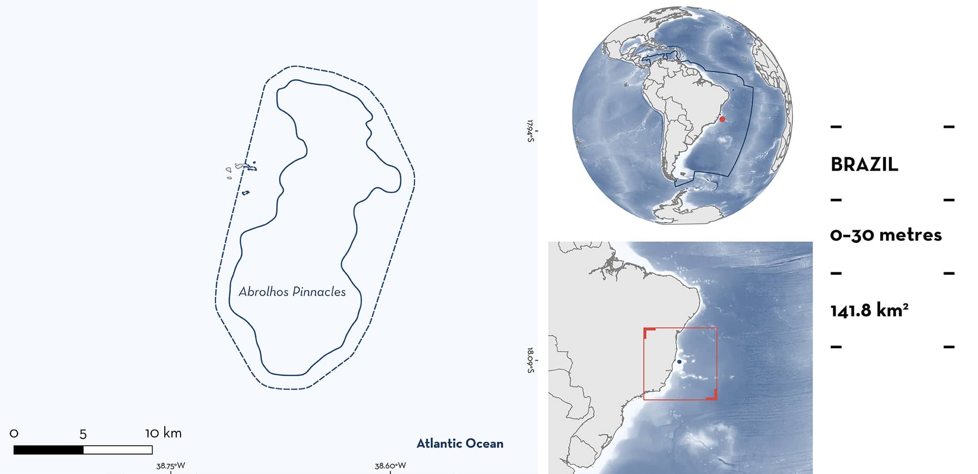
Abrolhos Pinnacles is located in the state of Bahia, Brazil. It is situated off the coast on the continental shelf. This area is characterised by a coral reef complex that includes quasi-emergent isolated mushroom-shaped reefs, surrounded by unconsolidated sediments. The area overlaps with the Abrolhos Marine National Park, the Abrolhos Bank and Vitória-Trindade Chain Ecologically or Biologically Significant Marine Area, and the Abrolhos Marine National Park Ramsar Site. Within this area there are: threatened species and reproductive areas (Caribbean Reef Shark Carcharhinus perezi).
Download factsheet
Abrolhos Pinnacles
DESCRIPTION OF HABITAT
Abrolhos Pinnacles is located in the state of Bahia, Brazil. It is situated off the coast on the continental shelf. This area is characterised by a coral reef complex that includes emergent and quasi-emergent isolated mushroom-shaped reefs (pinnacles) that can reach 25 m in height, surrounded by unconsolidated sediments (Leão et al. 2003). The eastern coast of tropical South America receives substantial riverine input and terrigenous sedimentation, influencing sediment composition, turbidity, and nutrient levels (Bastos et al. 2018). Dissolved inorganic nitrogen and phosphorus concentrations in Abrolhos exceed commonly assumed eutrophication thresholds, supporting high phytoplankton productivity. Seawater temperatures range from 21.7–29.6°C (Bastos et al. 2018).
The area overlaps with the Abrolhos Marine National Park (UNEP-WCMC & IUCN 2024), the Abrolhos Bank and Vitória-Trindade Chain Ecologically or Biologically Significant Marine Area (EBSA; CBD 2025), and the Abrolhos Marine National Park Ramsar Site (Ramsar 2025).
This Important Shark and Ray Area is pelagic and is delineated from surface waters (0 m) to 30 m based on the depth range of habitat in the area.
CRITERION A
VULNERABILITY
One Qualifying Species considered threatened with extinction according to the IUCN Red List of Threatened Species regularly occurs in the area. This is the Endangered Caribbean Reef Shark (Carlson et al. 2021).
CRITERION C
SUB-CRITERION C1 – REPRODUCTIVE AREAS
Abrolhos Pinnacles is an important reproductive area for one shark species.
In April 2015, 60 Baited Remote Underwater Video Station (BRUVS) surveys were deployed within the broader Abrolhos Bank region and Caribbean Reef Sharks were recorded only within this area (Schmid et al. 2022). Between January–February 2017, 90 BRUVS surveys were deployed in the broader Abrolhos area, including 54 within this area. Caribbean Reef Sharks were only recorded within this area, in 26% of deployments, with the maximum number of individuals in a video frame (MaxN) ranging from one to three (Rolim et al. 2022). The total length (TL) of the Caribbean Reef Sharks observed was estimated between 69–203 cm TL (mean = 90.8 cm TL). Of the 15 Caribbean Reef Sharks measured in the BRUVS, 14 animals were considered to be neonate/young-of-the-year with estimated sizes between 69–97 cm TL. The size-at-birth of Caribbean Reef Sharks is 70 cm TL (Ebert et al. 2021). Additionally, during the FinPrint project undertaken in 2018, 90 BRUVS were deployed in the area and broader region (Simpfendorfer et al. 2023). Of these, 25 were within this area. Caribbean Reef Sharks were recorded in four deployments, all within this area (MaxN = 12 at 17.3 m depth) (Simpfendorfer et al. 2023). These animals measured an estimated 90–110 cm TL. Finally, five YOY Caribbean Reef Sharks measuring <100 cm TL and captured within this area between 1997–1999 are in ichthyology collections supporting the historic use of this area in the early life stages of this species (Garla et al. 2006). This is the only known area in the Brazilian Shelf where the early stages of the Caribbean Reef Shark are regularly recorded. Other areas are the oceanic islands Trindade, Fernando de Noronha, and Rocas Atoll (Garla et al. 2006).
Download factsheet
SUBMIT A REQUEST
ISRA SPATIAL LAYER REQUEST
To make a request to download the ISRA Layer in either a GIS compatible Shapefile (.shp) or Google Earth compatible Keyhole Markup Language Zipped file (.kmz) please complete the following form. We will review your request and send the download details to you. We will endeavor to send you the requested files as soon as we can. However, please note that this is not an automated process, and before requests are responded to, they undergo internal review and authorization. As such, requests normally take 5–10 working days to process.
Should you have questions about the data or process, please do not hesitate to contact us.


