ISRA FACTSHEETS
ISRA FACTSHEETS
SOUTH AMERICAN INLAND WATERS
Bita-Meta-Orinoco Confluence
Summary
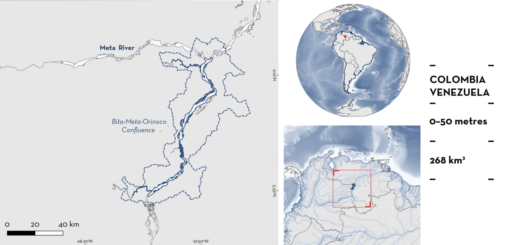
Bita-Meta-Orinoco Confluence is located in the middle section of the Orinoco Basin at the border between Colombia and Venezuela. This area is characterised by clearwater and whitewater rivers. It is influenced by the flow of the Bita River and Meta River into the Orinoco River. This area overlaps with the Bita River Ramsar Site and Parque Nacional Natural El Tuparro. Within this area there are: threatened species and range-restricted species (Orinoco Discus Stingray Paratrygon orinocensis).
Download factsheet
Bita-Meta-Orinoco Confluence
DESCRIPTION OF HABITAT
Bita-Meta-Orinoco Confluence is located in the middle section of the Orinoco Basin at the border between Colombia, in the Vichada Department, and Venezuela, in the Apure Department. In this area, the Bita River is characterised by clearwaters while the Meta River is characterised by whitewaters. They flow into the Orinoco River, characterised by whitewaters. Whitewater rivers are the most productive; their colour and turbidity are related to inorganic sediments, and clay, transported from the Andes to the alluvial plains (Sioli 1975). Clearwater rivers have a medium productivity and come from relatively flat areas, covered with forests that serve to attenuate the erosive effect of the rains, which then penetrate the soil without producing runoff (Sioli 1975). This area comprises wetlands, rivers, and lagoons that are under the influence of a unimodal rainfall regime, with higher precipitations between April–May to November and a drier period from December to March–April (Romero et al. 2017).
This area overlaps with the Bita River Ramsar Site (Ramsar 2025) and Parque Nacional Natural El Tuparro (UNEP-WCMC 2025).
This Important Shark and Ray Area is benthic and is delineated from surface waters (0 m) to 50 m based on the depth range of Qualifying Species in the area.
CRITERION A
VULNERABILITY
One Qualifying Species considered threatened with extinction according to the IUCN Red List of Threatened Species regularly occurs in the area. This is the Vulnerable Orinoco Discus Stingray (Torres et al. submitted b).
CRITERION B
RANGE RESTRICTED
This area holds the regular presence of the Orinoco Discus Stingray as a resident range-restricted species. This species was only described in 2021 (Loboda et al. 2021) and its occurrence has been reported in only three studies (Muñoz-Osorio & Mejía-Falla 2013; Lasso et al. 2016; Loboda et al. 2021).
A pregnant Orinoco Discus Stingray was captured in March 2009 in this area (Muñoz-Osorio & Mejía-Falla 2013; Torres et al. submitted b). Between 2013–2014, another study examined 22 Orinoco Discus Stingrays, in which 16 (72%) were collected in this area with the other individuals recorded in the lower section of the Orinoco River (~700 km apart from this area) and upper section of Rio Apure (~250 km apart from this area) (Loboda et al. 2021). The individuals from this area measured 17.4–38.2 cm disc width (DW). Between 2011–2016, surveys were carried out during the dry season, in tributary rivers of the Colombian Orinoquia, at seven sampling points characterised by three different types of waters (i.e., clear, white, and black waters) (Lasso et al. 2016). Orinoco Discus Stingrays were captured using a variety of methods and fishing gears (daytime freediving, nighttime boat trips, shore-based fishing; using longlines, harpoon, hand nets) (Lasso et al. 2016). All Orinoco Discus Stingrays collected (reported as Paratrygon sp. 1) were from this area (females = 15, males = 5) measuring between 17.7–80 cm DW. The size-at-birth of this species is estimated to be ~23–24 cm DW (Torres et al. submitted b), with maturity size for females estimated at 45 cm DW and 40 cm DW for males (Loboda et al. 2021). Therefore, this area provides an important area for different life-stages of this species. Orinoco Discus Stingray is endemic to the Orinoco Basin in Colombia and Venezuela (Torres et al. submitted b). It occurs in the mid-section of the Apure River, Bita River, and mid to lower section of the Orinoco River, downstream to its delta (Loboda et al. 2021).
Download factsheet
SUBMIT A REQUEST
ISRA SPATIAL LAYER REQUEST
To make a request to download the ISRA Layer in either a GIS compatible Shapefile (.shp) or Google Earth compatible Keyhole Markup Language Zipped file (.kmz) please complete the following form. We will review your request and send the download details to you. We will endeavor to send you the requested files as soon as we can. However, please note that this is not an automated process, and before requests are responded to, they undergo internal review and authorization. As such, requests normally take 5–10 working days to process.
Should you have questions about the data or process, please do not hesitate to contact us.


