ISRA FACTSHEETS
ISRA FACTSHEETS
MEDITERRANEAN AND BLACK SEAS REGION
Central Catalonia
Summary
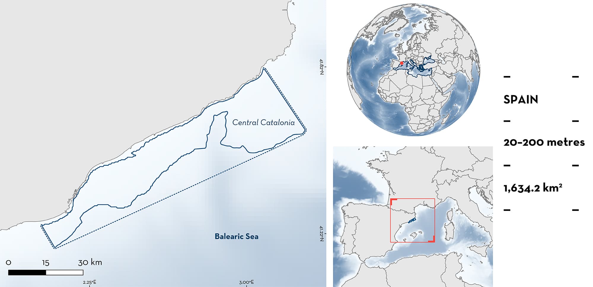
Central Catalonia is located along the continental shelf of Barcelona and Girona in Spain. The area has a broad continental shelf extending to 200 m depth characterised by a high productivity. The area includes sandy and muddy substrates, rocky coasts, and submarine canyons. This area includes three Natura 2000 areas, two Special Protection Areas, partially overlaps with two Key Biodiversity Areas, and sits within an Ecologically or Biologically Significant Marine Area. Within this area there are: range restricted species (Starry Skate Raja asterias); reproductive areas (Smallspotted Catshark Scyliorhinus canicula); and feeding areas (Starry Skate).
Download factsheet
Central Catalonia
DESCRIPTION OF HABITAT
Central Catalonia is located in the northeast of the Iberian Peninsula in Spain. This area in the northwest Mediterranean Sea is characterised by the presence of the Liguro-Provençal-Catalan Current that follows the continental shelf towards the west and south according to the geostrophic equilibrium. This, combined with the winter disruption of the thermocline and the river discharge of the Ebro and other rivers, causes a huge input of nutrients to the Catalan Sea increasing productivity (Estrada 1996; Basterretxea et al. 2018).
Overall, the area has a broad continental shelf to 200 m depth. The northern part of the area has a narrower continental shelf with prominent submarine canyons. The substrate consists mainly of a rocky coast, with a predominance of sand and sandy-muddy bottoms. The southern part has a wider continental shelf with some underwater canyons with muddy-sandy substrates. These benthic environments are rich in calcareous algae, molluscs, and echinoderms (Demestre et al. 2000).
Central Catalonia includes three areas designated as Natura 2000 sites: Espacio marino del Baix Llobregat-Garraf (ES0000513) protected under the Birds Directive; and Massís de les Cadiretes (ES5120013) and Delta del Llobregat (ES0000146) protected under both the Birds and Habitats Directives.
This area is within an Ecologically or Biologically Significant Marine Area (EBSA), the North-western Mediterranean Benthic Ecosystems EBSA (CBD 2023) and partially overlaps with two Key Biodiversity Areas: Aguas del Baix Llobregat – Garraf, and Plataforma Marina del Delta del Ebro – Columbretes (KBA 2023a, 2023b).
This Important Shark and Ray Area is benthic from 20 to 200 m based on the bathymetry of the area and the depth range of Qualifying Species in the area.
CRITERION B
RANGE RESTRICTED
This area holds the regular presence of the Starry Skate as resident range-restricted species. This species occurs year-round in the area and is regularly caught as bycatch during commercial fishing operations (Abelló & Guerao 1999; Barría et al. 2015; Navarro et al. 2016). Starry Skate occurs only in the Mediterranean Sea Large Marine Ecosystem.
CRITERION C
SUB-CRITERION C1 – REPRODUCTIVE AREAS
Central Catalonia is an important reproductive area for one shark species.
Based on Mediterranean International Trawl Survey (MEDITS) data (2002–2016), Central Catalonia holds a high abundance of the Smallspotted Catshark (30 to 300 individuals/km2) (Navarro et al. 2016) being one of the two shark species most captured in the area (Barría 2017). Egg cases of Smallspotted Catsharks are regularly found in trawl nets (A. Sanjaume pers. obs. 2023). The abundance of egg cases has been quantified based on surveys from captures in trawl fishing operations between May 2020 and February 2022, identifying an average density in this area of 59 egg cases/km2, with a maximum of 639 egg cases/km2 (Ceballos 2023; D. Ruiz-García et al. unpubl. data 2023). Two hotspots of high density (>580 egg cases/km2) have been identified in front of Llobregat Delta and in front of Sant Feliu de Guixols, situated respectively at the north and south of Central Catalonia.
The highest egg case abundance was located at ~100 m depth (Ceballos 2023; D. Ruiz-García et al. unpubl. data 2023). Morphological identification keys were used to identify egg cases to species (Porcu et al. 2017; Mancusi et al 2021).
CRITERION C
SUB-CRITERION C2 – FEEDING AREAS
Central Catalonia is an important feeding area for Starry Skate.
The area is a productive location within a mostly oligotrophic region. Stomach content and stable isotope analysis have been used to describe the diet of Starry Skate. Both techniques indicated that diet was composed of crustaceans, principally the Angular Crab (Goneplax rhomboidesk) and Harbour Crab (Liocarcinus depurator) (Barría et al. 2015; Navarro et al. 2013). Crustaceans are very abundant in the area (Barría et al. 2015; Navarro et al. 2016; Ramírez-Amaro et al. 2020). Both crab species are the dominant crustaceans in terms of both biomass and abundance (Abelló et al. 1988, 2002). This area is an important feeding ground for the range-restricted Starry Skate, due to the high and constant abundance of its main preys throughout the year in this area (Abelló & Guerao 1999).
Download factsheet
SUBMIT A REQUEST
ISRA SPATIAL LAYER REQUEST
To make a request to download the ISRA Layer in either a GIS compatible Shapefile (.shp) or Google Earth compatible Keyhole Markup Language Zipped file (.kmz) please complete the following form. We will review your request and send the download details to you. We will endeavor to send you the requested files as soon as we can. However, please note that this is not an automated process, and before requests are responded to, they undergo internal review and authorization. As such, requests normally take 5–10 working days to process.
Should you have questions about the data or process, please do not hesitate to contact us.


