ISRA FACTSHEETS
ISRA FACTSHEETS
WESTERN INDIAN OCEAN REGION
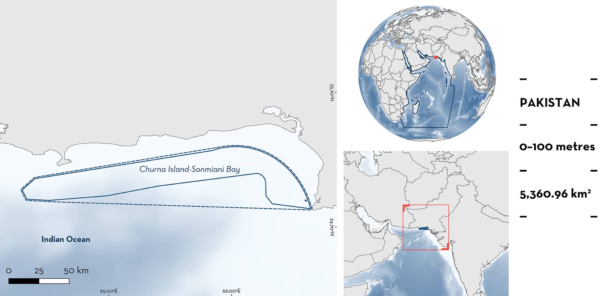
Churna Island-Sonmiani Bay
Summary
Churna Island-Sonmiani Bay is located off Balochistan and Sindh provinces, Pakistan. The area extends from Cape Monz and Churna Island in the east to waters off Ormara in the west. Habitat consists of epipelagic waters above sandy, muddy, and rocky substrates. The area overlaps with Churna-Kaio Island Complex Ecologically or Biologically Significant Marine Area (EBSA) and Malan-Gwadar Bank EBSA. Within this area there are: threatened species (e.g., Oceanic Manta Ray Mobula birostris); and feeding areas (e.g., Longhorned Pygmy Devil Ray Mobula eregoodoo).
Download factsheet
Churna Island-Sonmiani Bay
DESCRIPTION OF HABITAT
Churna Island-Sonmiani Bay is located off Balochistan and Sindh provinces, Pakistan. The area extends from Cape Monz and Churna Island in the east to waters off Ormara in the west. Habitat consists of epipelagic waters above sandy, muddy, and rocky substrates. Churna Island, a small uninhabited island, has a rocky shoreline, with sandy and rocky substrates and coral assemblages.
The area is influenced by the repeated reversal of the monsoon which causes deep convective mixing especially during the northeast monsoon bringing nutrient rich water to the surface supporting high productivity in the Arabian Sea (Wiggert et al. 2000; Marra & Barber 2005). Wave action for most part of year is intense especially during the southwest monsoon (mid-May to mid-September), however, during the rest of the period the sea conditions remain calm or with only moderate wave action. During November and February, the current in the area flows in an anticlockwise direction while during the remaining part of the year it is clockwise.
This area overlaps with Churna-Kaio Island Complex Ecologically or Biologically Significant Marine Area (EBSA) (CBD 2023a) and Malan-Gwadar Bank EBSA (CBD 2023b).
This Important Shark and Ray Area is pelagic and is delineated from surface waters (0 m) to 100 m based on the occurrence of the Qualifying Species in the area.
CRITERION A
VULNERABILITY
Seven Qualifying Species considered threatened with extinction according to the IUCN Red List of Threatened SpeciesTM regularly occur in the area. Threatened sharks comprise one Endangered species; threatened rays comprise six Endangered species (IUCN 2023).
CRITERION C
SUB-CRITERION C2 – FEEDING AREAS
Churna Island-Sonmiani Bay is an important feeding area of one shark and six ray species.
The area is a hotspot for devil ray diversity comprising an assemblage of Oceanic Manta Ray, Longhorned Pygmy Devil Ray, Shorthorned Pygmy Devil Ray, Spinetail Devil Ray, Sicklefin Devil Ray, and Bentfin Devil Ray (Moazzam 2018; Moazzam & Osmany 2021). Understanding of the species composition comes from direct field observations, interviews with fishers, and monitoring of landed catches at nearby fish markets (particularly Karachi Fish Harbour which is nearby Churna Island-Sonmiani Bay (Moazzam 2018; Moazzam & Osmany 2021). This assemblage is not recorded elsewhere along the Pakistan coast (Moazzam unpubl. data 2023).
The area is known for its dense concentration of pelagic sergestid shrimps which attracts Whale Shark, devil rays, and other filter-feeding marine megafauna to the area following the boreal winter in March to May (Moazzam et al. 2020). Stomach content analysis of devil rays caught in the area have verified the presence of pelagic shrimps (Moazzam & Kazmi unpubl. data 2023). Whale Sharks and devil rays are regularly observed swimming at the surface in what is considered to be feeding behaviour (Moazzam pers. obs. 2023). Interviews with fishers indicate that they also regularly observe the assemblage of devil rays during the same period (March to May) and that there are frequent observations of devil rays leaping out of the water during this period (Moazzam unpubl. data 2023). This area has long been known to be a hotspot for Whale Shark and devil rays which were historically hunted in the area by harpoon (Tombazi 1934; Whitley 1936), while this activity did not occur elsewhere along the Pakistan coast.
Download factsheet
SUBMIT A REQUEST
ISRA SPATIAL LAYER REQUEST
To make a request to download the ISRA Layer in either a GIS compatible Shapefile (.shp) or Google Earth compatible Keyhole Markup Language Zipped file (.kmz) please complete the following form. We will review your request and send the download details to you. We will endeavor to send you the requested files as soon as we can. However, please note that this is not an automated process, and before requests are responded to, they undergo internal review and authorization. As such, requests normally take 5–10 working days to process.
Should you have questions about the data or process, please do not hesitate to contact us.


