ISRA FACTSHEETS
ISRA FACTSHEETS
CENTRAL AND SOUTH AMERICAN PACIFIC REGION
Costa Rica Thermal Dome
Summary
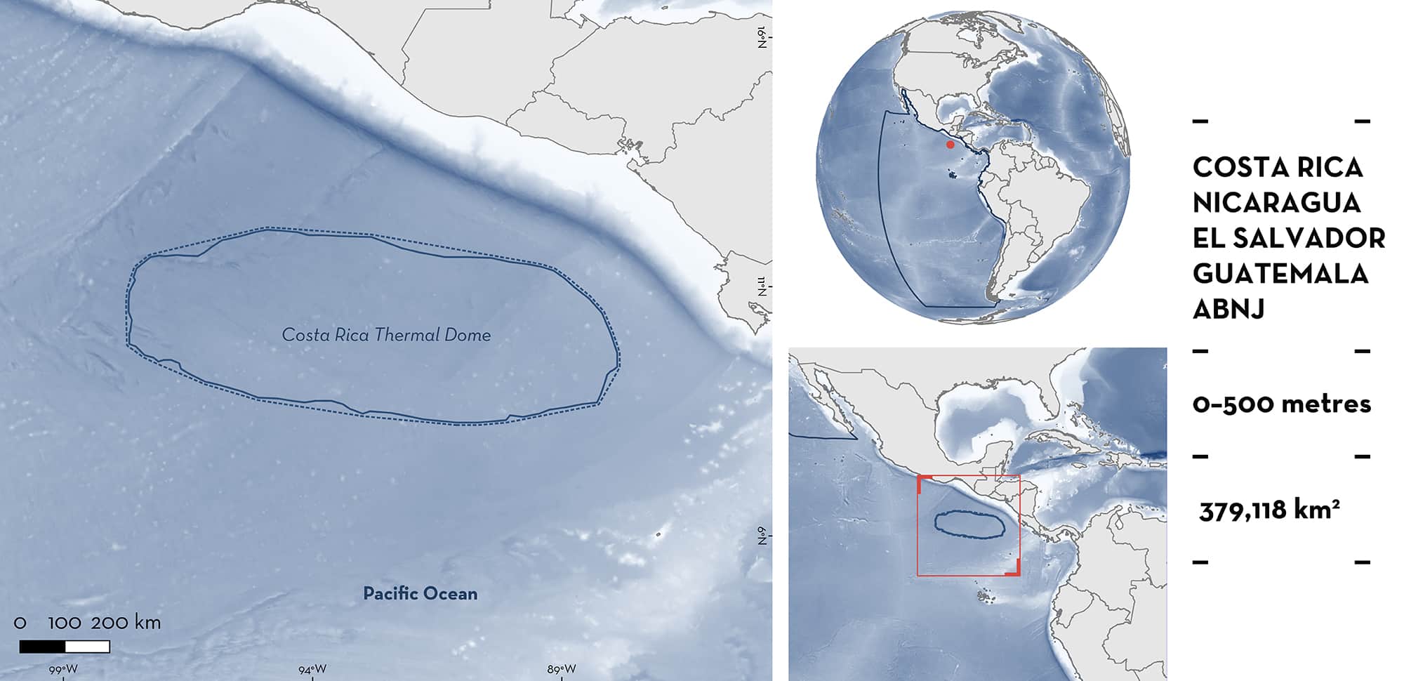
Costa Rica Thermal Dome is located in the Eastern Tropical Pacific covering part of Costa Rica, Nicaragua, El Salvador, Guatemala, and Areas Beyond National Jurisdiction (ABNJ). This area overlaps with the Papagayo Ecological or Biological Significant Marine Area. It includes a productive and oceanographically dynamic offshore upwelling system and plays an important role as a significant carbon sink with a high concentration of nutrients. Within this area there are: threatened species (e.g., Munk’s Pygmy Devil Ray Mobula munkiana); feeding areas (e.g., Spinetail Devil Ray Mobula mobular); and undefined aggregations (Silky Shark Carcharhinus falciformis).
Download factsheet
Costa Rica Thermal Dome
DESCRIPTION OF HABITAT
Costa Rica Thermal Dome is located in the Eastern Tropical Pacific encompassing parts of the Exclusive Economic Zones of Costa Rica, Nicaragua, El Salvador, and Guatemala as well as Areas Beyond National Jurisdiction (ABNJ). Situated within the Pacific Central-American Large Marine Ecosystem and its adjacent oceanic waters, the Dome is a non-static, dynamic, seasonal, and predictable oceanographic feature created by ocean currents and winds which draw deeper nutrient-rich waters towards the surface (Fielder 2002).
The Costa Rica Thermal Dome is generated mainly by the proximity to the surface of the Northern Equatorial Counter Current flank, as well as by seasonal changes in interconnected phenomena: coastal wind jets, eddies, the Intertropical Convergence Zone, the geostrophic balance, and the upwelling of the thermocline close to 10°N. In some years, the Dome is closer to the coast and in others is further offshore. Unlike other upwellings, the Dome is unique because it is formed by a coastal wind jet from the Gulf of Papagayo in Nicaragua and Costa Rica (Ross Salazar et al. 2019). This generates an area of high primary productivity, which maintains a diverse, complex food web.
This Important Shark and Ray Area is delineated according to the area in which the Dome persisted in the month of September over a period of 30 years (1980–2009); this boundary was refined to its persistence between 11 and 15 years (Ross Salazar et al. 2019). It is delineated from surface waters (0 m) to a depth of 500 m based on the habitat used by the Qualifying Species.
CRITERION A
VULNERABILITY
Six Qualifying Species considered threatened with extinction according to the IUCN Red List of Threatened SpeciesTM regularly occur in the area. Threatened sharks comprise one Vulnerable species; threatened rays comprise four Endangered and one Vulnerable species (IUCN 2022).
CRITERION C
SUB-CRITERION C2 – FEEDING AREAS
Costa Rica Thermal Dome is an important feeding area for five ray species: Oceanic Manta Ray, Spinetail Devil Ray, Munk’s Pygmy Devil Ray, Sicklefin Devil Ray, and Bentfin Devil Ray.
The spatial distribution of devil rays (Mobula spp.) in the eastern Pacific Ocean can be explained by variable environmental conditions such as highly productive upwelling zones and prey availability (Crol et al. 2012; Lezama-Ochoa et al. 2019a). Preliminary observations point to a strong association of devil rays to oceanographic conditions of high productivity, such as those found in the Costa Rica Thermal Dome (Hall & Roman 2013; Lezama-Ochoa et al. 2019a, 2019b).
During boreal summer (July-August), this area is an oceanic centre of production as the Costa Rica Thermal Dome is a mesoscale structure with high productivity (Hall and Roman 2013; Lezama-Ochoa et al. 2019a, 2019b). The upwelling systems in this area act as a hotspot for the regular and predictable presence of devil rays (Lezama-Ochoa et al. 2019a, 2019b). Chlorophyll concentration (0.5–1mg/m-3) has been suggested to be an important variable for their presence indicating a direct relationship with productive upwelling systems. Devil ray catches in this area were concentrated to areas of high productivity and prey density, suggesting a direct relation to food availability (Lezama-Ochoa 2019b).
CRITERION C
SUB-CRITERION C5 – UNDEFINED AGGREGATIONS
Costa Rica Thermal Dome is an important area for Silky Shark aggregations. Juvenile Silky Sharks aggregate around drifting fish aggregating devices (FADs) (Filmalter et al. 2017). These devices are commonly used within commercial purse seine fisheries in the Eastern Tropical Pacific (Hall 1998). Silky Shark is the main shark species caught as bycatch in these fisheries. The highest abundance and frequency of Silky Sharks are from within the Costa Rica Thermal Dome. Between 1994–2009, the highest proportion of Silky Sharks caught in this area were juveniles and was associated with floating objects. The observation of juvenile Silky Sharks aggregating around floating objects is predictable behaviour and denotes their susceptibility to being caught in large numbers around FADs deployed in purse seine fisheries (Filmalter et al. 2015, 2017; Hall & Roman 2013). Although aggregation size cannot be extracted from these fisheries data, it is the tendency of Silky Sharks to aggregate which attributes to their regular high bycatch rate in this area. The purpose of these aggregations is unknown.
Download factsheet
SUBMIT A REQUEST
ISRA SPATIAL LAYER REQUEST
To make a request to download the ISRA Layer in either a GIS compatible Shapefile (.shp) or Google Earth compatible Keyhole Markup Language Zipped file (.kmz) please complete the following form. We will review your request and send the download details to you. We will endeavor to send you the requested files as soon as we can. However, please note that this is not an automated process, and before requests are responded to, they undergo internal review and authorization. As such, requests normally take 5–10 working days to process.
Should you have questions about the data or process, please do not hesitate to contact us.


