ISRA FACTSHEETS
ISRA FACTSHEETS
MEDITERRANEAN AND BLACK SEAS REGION
Egadi Archipelago
Summary
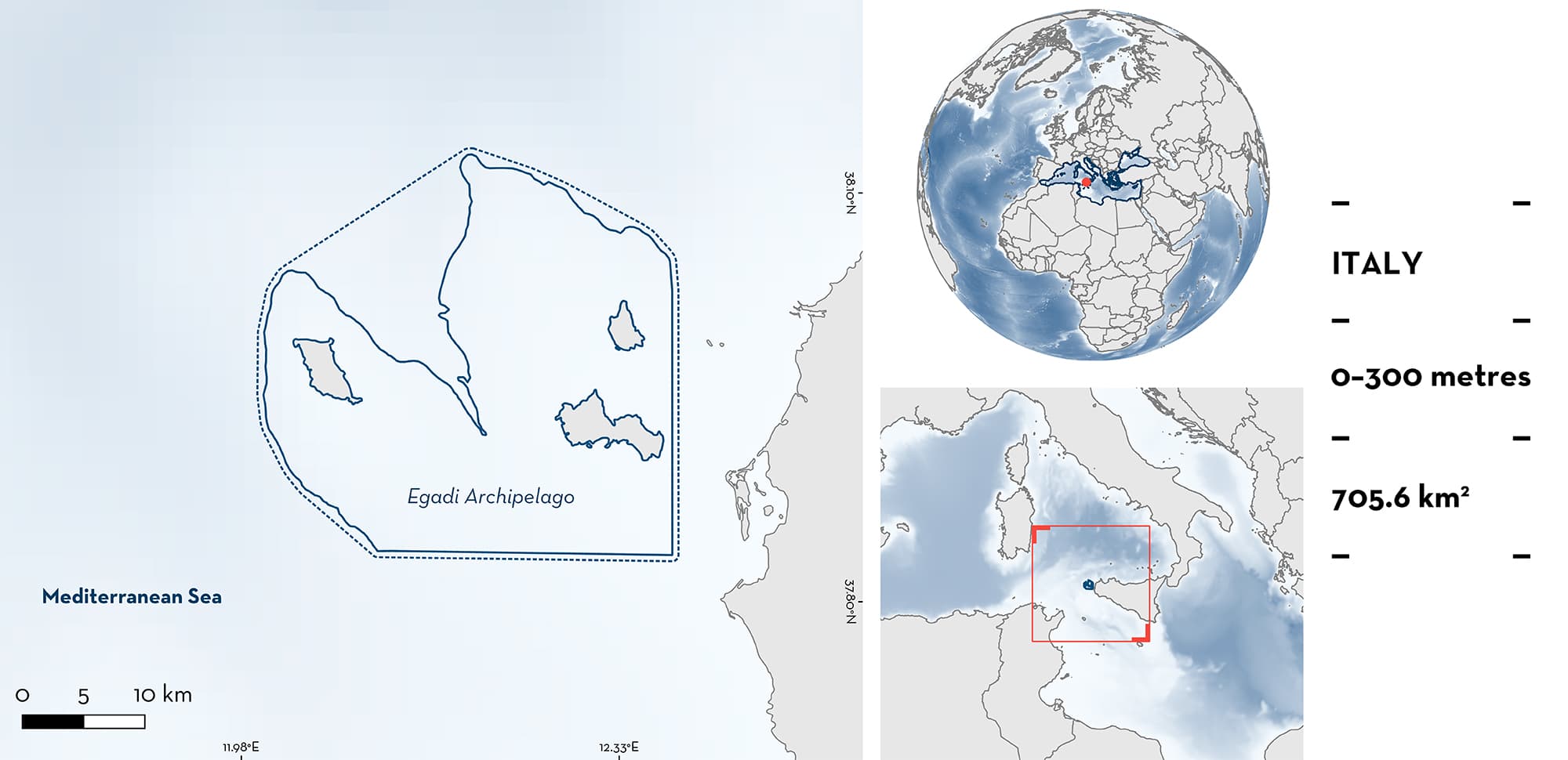
Egadi Archipelago is located in the northwestern part of the Sicily Channel bordering the Tyrrhenian Sea. This area includes the three islands of the Egadi Archipelago (Favignana, Levanzo, and Marettimo Islands). It overlaps entirely with a national marine protected area and a special protection area. It is also located within the southern border of the Tyrrhenian Ecological Protection Zone and within the northern border of the Sicily Channel Ecologically and Biologically Significant Marine Area. The area encompasses continental shelves mostly extending southeast to 130 m depth and crossing a canyon that connects Sicily Island to the Tyrrhenian abyssal plain. Within this area there are: threatened species (e.g., Common Eagle Ray Myliobatis aquila); range restricted species (Rough Skate Raja radula); reproductive areas (Common Eagle Ray); and undefined aggregations (Smallspotted Catshark Scyliorhinus.
Download factsheet
Egadi Archipelago
DESCRIPTION OF HABITAT
Egadi Archipelago is located in Italy, north of the Sicilian Channel, between the Trapani Basin (in the north), the Western Bank (northwest), the Skerki Bank (west), Avventura Bank (south), and the western coast of Sicily Island. The area encompasses continental shelves mostly extending southeast to 130 m depth and crossing a canyon that connects Sicily Island to the Tyrrhenian abyssal plain. The Marettimo Channel (350 m depth) divides the area into two sectors: the Islands of Favignana and Levanzo in the east, and Marettimo Island in the west, which are interconnected by a shallow platform (30 m depth). The Modified Atlantic Water flows eastward from the Sardinia Channel, while in the opposite direction, the Levantine Intermediate Water, produced in the eastern Mediterranean Sea, spreads out westward after crossing the Sicilian Channel at ~200 m depth. The topography of the seafloor forces Levantine Intermediate Water to cross the Egadi Archipelago offshore area and to turn eastward to enter the Tyrrhenian Sea. The area is characterised by a diversity of habitat types such as seagrass meadows, deep-sea reef habitats, and underwater canyons and shoals.
This Important Shark and Ray Area is benthopelagic and is delineated from inshore and surface waters (0 m) to 350 m based on the bathymetry of the area.
CRITERION A
VULNERABILITY
Two Qualifying Species considered threatened with extinction according to the IUCN Red List of Threatened SpeciesTM regularly occur in the area. These are the Critically Endangered Common Eagle Ray (Jabado et al. 2021), and the Endangered Rough Skate (Mancusi et al. 2016).
CRITERION B
RANGE RESTRICTED
This area holds the regular presence of Rough Skate as a resident range-restricted species. This species only occurs in the Mediterranean Large Marine Ecosystem.
Rough Skates between 29–62 cm total length (TL) were regularly caught between June 2017 and October 2018 in small-scale local fisheries operating in the area (biomass catch-per-unit-effort [BCPUE] 84 ± 29 g/1,000 m net; mean ± SE; number of individuals catch-per-unit-effort [NCPUE] 0.5 ± 0.1 n/1,000 m net) (Di Lorenzo et al. 2022). Fishery monitoring surveys conducted in the boreal summer 2022 and winter 2023 (D. Grancagnolo & M. Milazzo unpubl. data 2023) confirm the regular presence of the species in landings from trammel nets. In the region, catches of Rough Skate were made exclusively in the area, not in surrounding areas (Di Lorenzo et al. 2022; D. Grancagnolo & M. Milazzo unpubl. data 2023). Occurrences of Rough Skate in the area are the highest of the region and more than 20 times higher than in Strait of Sicily (M. Milazzo pers. obs. 2023).
CRITERION C
SUB-CRITERION C1 – REPRODUCTIVE AREAS
The area is an important reproductive area for one ray species.
A reproductive aggregation of the Common Eagle Ray has been regularly observed since 2019 during summer by citizen scientists, monitored by Diver Operated Video systems (DOVs), and by Baited Remote Underwater Videos (BRUVs) in 2021 and 2022 (Grancagnolo & Arculeo 2021; Grancagnolo & Milazzo 2023). Aggregations of up to 93 (MaxN) individuals were recorded in the area in 2022. Data collected in August and September of the same year showed pre-mating interactions (71 events), courtship and mating behaviours (nine events), three mating events, and the presence of several pregnant females (Grancagnolo & Milazzo 2023). The presence of up to four pregnant females (MaxN) was recorded based on symmetrical swellings both on the back and on the belly of each individual, and swimming behaviour which included their separation into a single group away from other individuals recorded by DOVs in summer 2022.
CRITERION C
SUB-CRITERION C5 – UNDEFINED AGGREGATIONS
Egadi Archipelago is an important area for undefined aggregations of one shark species.
An aggregation of female Smallspotted Catshark has been reported through local ecological knowledge (LEK), BRUVs, and fishery landing monitoring programs in Marettimo Island in summer 2022 and winter 2023. Smallspotted Catsharks are regularly caught by trammel nets deployed overnight around Marettimo Island at 30–40 m depth (D. Grancagnolo & M. Milazzo unpubl. data 2023). Twenty individuals were the maximum number of landed animals in one trammel net haul, while on average (mean MaxN) 2.29 individuals per hour were captured on video by BRUVS (39 sightings, n = 17, 1 hour video) (Grancagnolo & Milazzo 2023). Catches and observations of Smallspotted Catsharks were higher in the area than in surrounding areas (Di Lorenzo et al. 2022; D. Grancagnolo & M. Milazzo unpubl. data 2023).
Download factsheet
SUBMIT A REQUEST
ISRA SPATIAL LAYER REQUEST
To make a request to download the ISRA Layer in either a GIS compatible Shapefile (.shp) or Google Earth compatible Keyhole Markup Language Zipped file (.kmz) please complete the following form. We will review your request and send the download details to you. We will endeavor to send you the requested files as soon as we can. However, please note that this is not an automated process, and before requests are responded to, they undergo internal review and authorization. As such, requests normally take 5–10 working days to process.
Should you have questions about the data or process, please do not hesitate to contact us.


