ISRA FACTSHEETS
ISRA FACTSHEETS
NEW ZEALAND & PACIFIC ISLANDS REGION
Gatokae
Summary
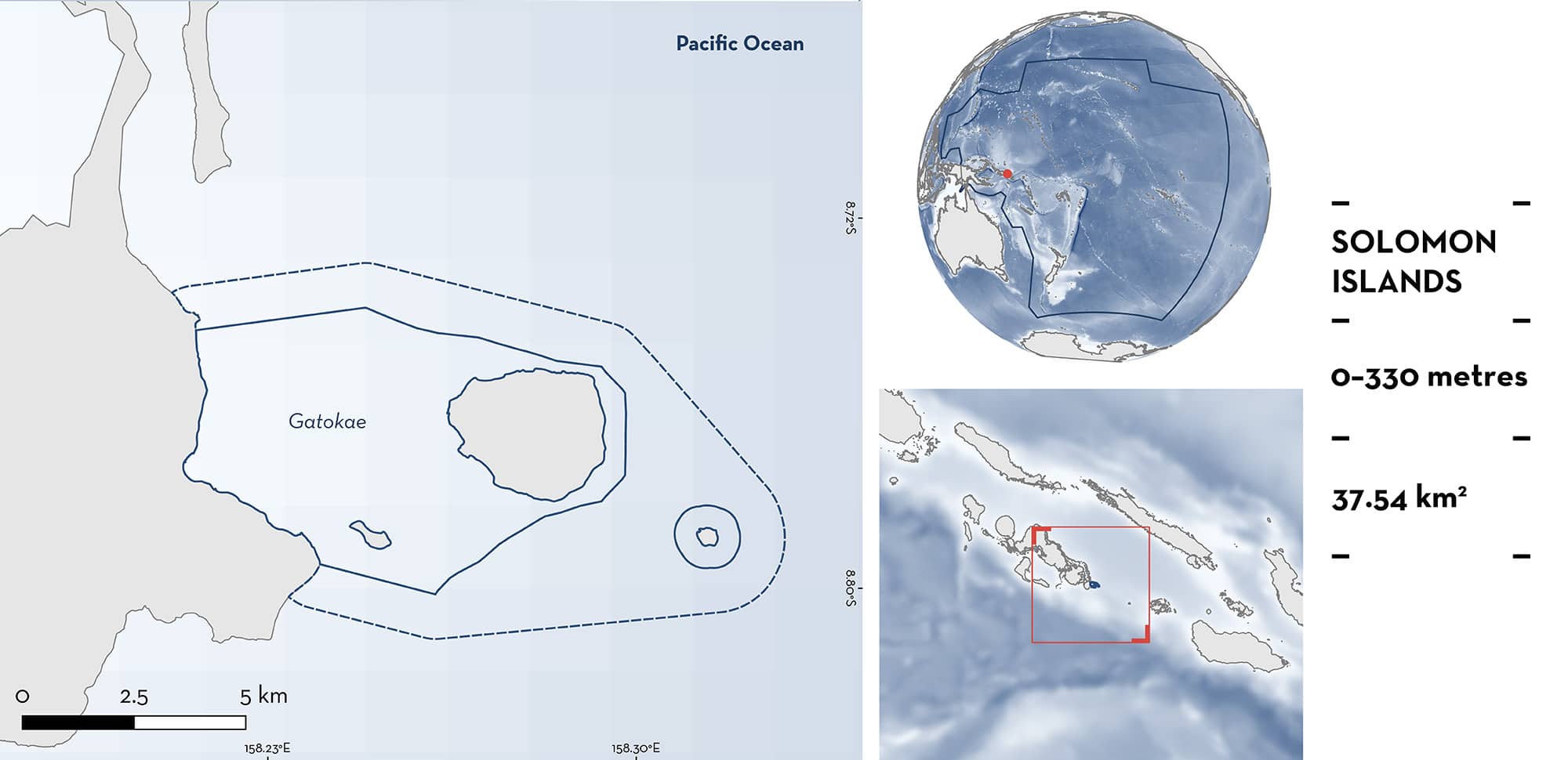
Gatokae is located in the New Georgia Islands of the Western Province in the Solomon Islands. The area is situated on the eastern side of Nggatokae Island encompassing Kicha, Malemale, and Mbulo Islands. The habitat is characterised by sandy patches, hard coral, caves, and steeply sloping reefs and walls covered with soft corals. Within this area there are: threatened species (e.g., Grey Reef Shark Carcharhinus amblyrhynchos) and undefined aggregations (e.g., Whitetip Reef Shark Triaenodon obesus).
Download factsheet
Gatokae
DESCRIPTION OF HABITAT
Gatokae is located in the New Georgia Islands of the Western Province in the Solomon Islands. It is situated on the eastern side of Nggatokae Island and includes Kicha, Malemale, and Mbulo Islands. It is adjacent to Marovo Lagoon, the largest saltwater lagoon in the world (Green et al. 2006). Nggatokae is a steep volcanic area with river systems and associated sediment outflow (Goetze et al. 2018). The habitat is characterised by sandy patches, hard coral, caves, and steeply sloping reefs and walls covered with soft corals (Green et al. 2006).
This Important Shark and Ray Area is benthopelagic and is delineated from surface waters (0 m) to a depth of 330 m based on the global depth range of the Qualifying Species.
CRITERION A
VULNERABILITY
Two Qualifying Species considered threatened with extinction according to the IUCN Red List of Threatened Species regularly occur in the area. These are the Endangered Grey Reef Shark (Simpfendorfer et al. 2020a), and the Vulnerable Whitetip Reef Shark (Simpfendorfer et al. 2020b).
CRITERION C
SUB-CRITERION C5 – UNDEFINED AGGREGATIONS
Gatokae is an important area for undefined aggregations of two shark species.
Regular and predictable aggregations of Grey Reef Sharks and Whitetip Reef Sharks in this area are supported by observations by recreational divers, spear fishers, and surveys using baited remote underwater video stations (BRUVS).
Between 2009–2024, recreational divers that visited Kicha Island, every month (up to three times), regularly observed Grey Reef Sharks (n = 2–5 individuals) mainly between 10–40 m depth (S Leeson pers. obs. 2024). Aggregations of ~15 Grey Reef Sharks are recorded during scuba diving (n = 3 videos from 2012–2014) and spearfishing dives (n = 3 videos from 2017–2019). Spearfishers report that aggregations can get up to hundreds of individuals. Fishers on Gatokae islands have reported sporadic, small-scale longline operations targeting mainly Grey Reef Sharks close to the reef edge (Goetze et al. 2018). Grey Reef Sharks have also been recorded feeding on bait balls that occur around December (n = 2 videos from 2012–2018). Grey Reef Sharks were confirmed as occurring at Malemale, Mbulo, and Kicha islands, and were observed in five of 20 BRUVS deployments (MaxN [maximum number of individuals of a species observed in a single frame] = 1; activity = 100% passing; Goetze et al. 2018). Deployments at depths between 10–25 m near the islands might explain the absence of Grey Reef Sharks reported to aggregate near the reef edge (Goetze et al. 2018). Size of individuals ranged from 71–81.4 cm fork length (FL) (average 76.1 cm FL) (Goetze et al. 2018). Size-at-birth of Grey Reef Sharks is 45–60 cm total length (TL) indicating those were young-of-the-year (YOY) (Ebert et al. 2021). Fishers also suggest that Grey Reef Sharks mate in this area. However, further information is required to determine the nature and function of these aggregations.
Whitetip Reef Sharks are regularly reported by divers on online dive blogs as occurring in high abundance in the area (2015, 2016, 2018). Between 2009–2024, recreational divers that visited Kicha Island, every month (up to three times), regularly observed between 2–5 Whitetip Reef Sharks within the area, mainly between 10–40 m depth. Aggregations of mainly three individuals (sometimes up to four) were seen swimming together once a month (S Leeson pers. obs. 2024). Within the area, Whitetip Reef Sharks were recorded in all islands, in nine of 20 BRUVS deployments (activity = 100% passing), supporting their presence and aggregation in the area (Goetze et al. 2018). The highest MaxN of Whitetip Reef Sharks in all 56 deployments in the Solomon Islands was within this area (MaxN = 5 at Malemale). When considering all BRUVS deployments from 2009–2019 that recorded Whitetip Reef Sharks around the world (n = 1,598), only 0.3% had more than five individuals in the same frame, and only 9.3% recorded more than two (Simpfendorfer et al. 2023). Within this area, from deployments that recorded Whitetip Reef Sharks (n = 9), 11.1% had more than five MaxN and 33.3% recorded more than two MaxN, highlighting the importance of this area compared to more than 130 sites sampled with the same method. The size of individuals ranged from 71.1–102.7 cm FL (average = 85 cm FL) (Goetze et al. 2018). Size-at-maturity is ~105 cm TL (Ebert et al. 2021), indicating these are juveniles. Further information is required to determine the nature and function of these aggregations.
Download factsheet
SUBMIT A REQUEST
ISRA SPATIAL LAYER REQUEST
To make a request to download the ISRA Layer in either a GIS compatible Shapefile (.shp) or Google Earth compatible Keyhole Markup Language Zipped file (.kmz) please complete the following form. We will review your request and send the download details to you. We will endeavor to send you the requested files as soon as we can. However, please note that this is not an automated process, and before requests are responded to, they undergo internal review and authorization. As such, requests normally take 5–10 working days to process.
Should you have questions about the data or process, please do not hesitate to contact us.


