ISRA FACTSHEETS
ISRA FACTSHEETS
CENTRAL AND SOUTH AMERICAN PACIFIC REGION
Golfo Dulce
Summary
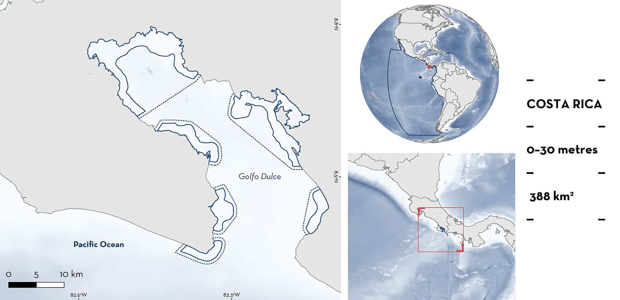
Golfo Dulce is a large tropical inlet located on the southern Pacific coast of Costa Rica. It encompasses an area that is approximately 50 km in length and 10–15 km wide with an effective sill of about 60 m at the entrance to the gulf. The inner basin area is deep (to 215 m) with an anoxic bottom, whereas the coastline has a shallow platform surrounded by diverse habitats including rainforest, mangroves, sandy beaches, soft-mud bottoms, seagrasses, and coral reefs. Local geomorphological features make this area one of the few low-circulation tropical systems known globally. Within this area there are: threatened species (e.g., Whale Shark Rhincodon typus); reproductive areas (Scalloped Hammerhead Sphyrna lewini); feeding areas (Whale Shark); and an area important for movements to offshore areas (Scalloped Hammerhead).
Download factsheet
Golfo Dulce
DESCRIPTION OF HABITAT
Golfo Dulce is a relatively large tropical inlet (700 km2) located on the southern Pacific coast of Costa Rica, in the province of Puntarenas. Situated in the Pacific Central-American Coastal Large Marine Ecosystem, the inlet is approximately 50 km in length, and 10–15 km wide with an effective sill of about 60 m at the entrance to the gulf (Dean 1996; Léon-Morales & Vargas 1998; Quirós 2003). The inner basin has a deep (to 215 m) and anoxic bottom, whereas the coastline has a shallow platform surrounded by diverse habitats including rainforest, mangroves, sandy beaches, soft-mud bottoms, seagrasses, and coral reefs (Svendsen et al. 2006). Golfo Dulce is a sheltered embayment with high productivity around its entrance, as tidal forces and riverine inputs increase nutrient levels (Lei 2002). This facilitates a high abundance of small fishes and plankton (Dean 1996). The gulf has special geomorphological features, which make it one of the few low-circulation systems described for tropical areas of the world.
This Important Shark and Ray Area is delineated from surface waters to a depth of 30 m based on the maximum depth range of the habitat used by the Qualifying Species.
CRITERION A
VULNERABILITY
There are two Qualifying Species considered threatened with extinction according to the IUCN Red List of Threatened SpeciesTM. These are the Critically Endangered Scalloped Hammerhead and the Endangered Whale Shark (Pierce and Norman 2016; Rigby et al. 2019).
CRITERION C
SUB-CRITERION C1 – REPRODUCTIVE AREAS
Golfo Dulce is an important reproductive area for one shark species. Artisanal fisher catch indicates that young-of-the-year and juvenile Scalloped Hammerheads (mean 74.3 ± 17.4 cm total length [TL]) are regularly caught in this area. Of 152 individuals observed in landings over a 1-year period, 48% were newborn (based on the presence of open umbilical scars and the size of animals) (Zanella & López-Garro 2015). The remaining 52% were considered juveniles based on clasper calcification and known size-at-maturity.
Seasonal variability was documented between July and August where landed Scalloped Hammerheads had the smallest mean size of 64 cm TL, with a high relative catch-per-unit-effort (CPUE) of 0.0075 (Zanella & López-Garro 2015). The use of Golfo Dulce area as a nursery is supported by the tagging of juveniles (87–102 cm TL) that were detected for up to 372 days (average of 245 days) (Zanella et al. 2019). These results indicate that there is high residency of Scalloped Hammerheads for at least one month (directly after tagging) with presence of up to a year. Data also suggest that Golfo Duce is used across multiple years and this area facilitates the recruitment of juvenile Scalloped Hammerheads into adult populations by connecting the juvenile habitat in Golfo Dulce to the wider Eastern Tropical Pacific (Zanella et al. 2019).
CRITERION C
SUB-CRITERION C2 – FEEDING AREAS
Golfo Dulce is an important feeding area for one shark species. Whale Shark feeding aggregations in groups of various sizes (up to 13 individuals per sighting) have been documented. These were recorded close to the Rincón and Tigre rivers on the northwestern coast of the inner basin, in January 2009, August 2009, March 2012, and January 2013. Whale Sharks were observed aggregating around copepods which are known to persist as a result of important nutrients sourced within the Rincón and Tigre rivers (Pacheco-Polanco et al. 2015). This feeding behaviour has also been observed outside of Golfo Dulce (Heyman et al. 2001; Rowat et al. 2009; Motta et al. 2010).
CRITERION C
SUB-CRITERION C4 – MOVEMENT AREAS
Golfo Dulce is an important area for the movement of one shark species. Tagging data for 10 Scalloped Hammerheads between June 2011 and June 2012 indicate that juveniles in Golfo Dulce are connected to the offshore adult populations in the wider Eastern Tropical Pacific (Zanella et al. 2019). High residency of juveniles within one month of being tagged was documented. Residency then decreased exponentially and only remained high for eight consecutive months for two tagged individuals (Zanella et al. 2019).
Download factsheet
SUBMIT A REQUEST
ISRA SPATIAL LAYER REQUEST
To make a request to download the ISRA Layer in either a GIS compatible Shapefile (.shp) or Google Earth compatible Keyhole Markup Language Zipped file (.kmz) please complete the following form. We will review your request and send the download details to you. We will endeavor to send you the requested files as soon as we can. However, please note that this is not an automated process, and before requests are responded to, they undergo internal review and authorization. As such, requests normally take 5–10 working days to process.
Should you have questions about the data or process, please do not hesitate to contact us.


