ISRA FACTSHEETS
ISRA FACTSHEETS
NEW ZEALAND & PACIFIC ISLANDS REGION
Hauraki Gulf
Summary
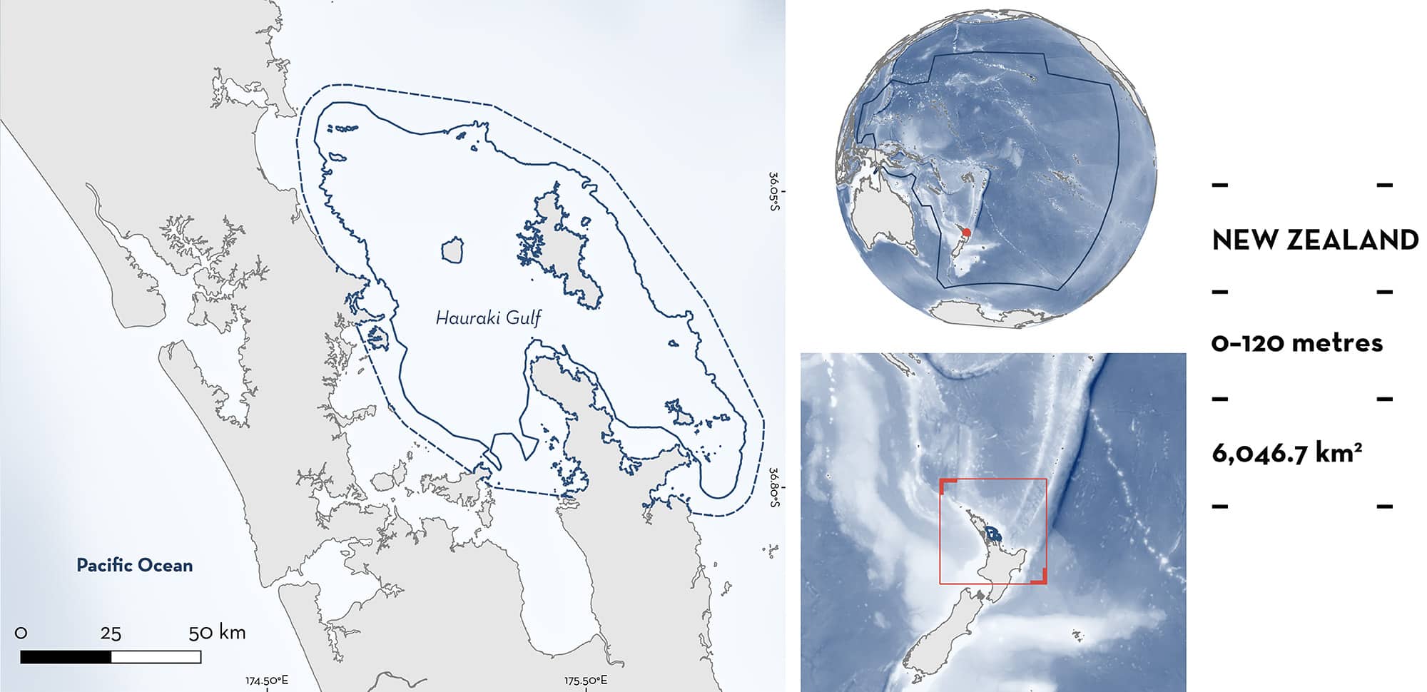
Hauraki Gulf is located on the northeast coast of the North Island of New Zealand. The area comprises a shallow semi-enclosed embayment, inner and outer shelfs, and 12 offshore islands. The narrow continental shelf (<40 km wide) promotes upwelling, making this region among the country’s most productive waters. Within this area there are: threatened species and feeding areas (Oceanic Manta Ray Mobula birostris).
Download factsheet
Hauraki Gulf
DESCRIPTION OF HABITAT
Hauraki Gulf is located on the northeast coast of the North Island of New Zealand. It covers a large area of continental shelf, comprised of a shallow semi-enclosed embayment, inner and outer shelfs and 12 offshore islands or island groups. The area is characterised by diverse habitats, ranging from shallow bays and estuaries to rocky reefs, and oceanic waters (Ozaki 2023). The inner Hauraki Gulf is semi-enclosed except in the north and northeast where its seaward boundaries are marked by offshore islands (Haututru/Little Barrier and Aotea/Great Barrier) through to the Mokohinau Islands, and Hen and Chicken Islands to the north. Reef systems exist in the middle of the channels with steep gradients exhibited from depths ranging between 20 to 60 m, with high nutrient levels in surface waters (Sharples 1997).
Hauraki Gulf and its adjacent waters are highly productive, supporting diverse year-round marine communities (Stephenson et al. 2023). The regions’ waters exhibit low salinity and nutrient-rich coastal waters, bordered seaward by the warm, nutrient-poor East Auckland Current flowing southeast from the East Australian Current and the Tasman Front, driving hydrodynamics in this region (Zeldis et al. 2004). Significant upwelling occurs along the entire 100 m depth contour, to the seaward side of the various offshore islands and rocky outcrops (Zeldis et al. 2004). Dense surface swarming krill Nyctiphanes australis is observed in the area. The key behavioural characteristic of this species is that it forms dense swarms at or just below the surface during the daytime (Kozmian-Ledward et al. 2021).
This Important Shark and Ray Area is benthic and pelagic and is delineated from inshore and surface waters (0 m) to 120 m based on the bathymetry of the area.
CRITERION A
VULNERABILITY
One Qualifying Species considered threatened with extinction according to the IUCN Red List of Threatened Species regularly occurs in the area. This is the Endangered Oceanic Manta Ray (Marshall et al. 2022).
CRITERION C
SUB-CRITERION C2 – FEEDING AREAS
Hauraki Gulf is an important feeding area for one ray species.
This area predictably attracts Oceanic Manta Rays annually from the austral spring to autumn (November–April) (Duffy et al. 2018; Ozaki et al. 2024). Between 1994–2024, there were 1,146 verified sightings in the area compiled through citizen science submissions and dedicated research efforts (L Green unpubl. data 2024). This represents 90% of the sightings of Oceanic Manta Rays throughout New Zealand’s waters (n = 1,276), supporting the importance of this area for this species. Through photo identification, researchers have confirmed 206 individuals since 2001 (males n = 53; females n = 145, unknown sex = 8) (L Green unpubl. data 2024).
Oceanic Manta Rays were observed feeding during 75% (n = 861) of sightings in the area (L Green unpubl. data 2024). Feeding aggregations range in size between 5–30 individuals during the peak season (December–February), with mass feeding aggregations (>50 individuals) observed several times a season (e.g., three in 2021, six in 2022, four in 2023, and seven to August 2024). Feeding aggregations can span several kilometres and coincide with dense surface swarming krill (L Green pers. obs. 2024). The narrow continental shelf (<40 km wide) promotes upwelling, making this region among the country’s most productive waters (Bradford-Grieve et al. 2006; Gaskin 2021). Between 2021–2024, aerial surveys using drones and boat-based encounters indicate that Oceanic Manta Rays are often engaged in somersault feeding behaviours when at the surface (L Green pers. obs 2024), indicating a densely concentrated prey environment (Stevens 2016).
Between 2021 and 2023, fine-scale satellite tracking of seven Oceanic Manta Rays (durations ranging 9–83 days) has also confirmed site fidelity to the Hauraki Gulf (Cooper 2024), supporting the importance of this area to this species.
Download factsheet
SUBMIT A REQUEST
ISRA SPATIAL LAYER REQUEST
To make a request to download the ISRA Layer in either a GIS compatible Shapefile (.shp) or Google Earth compatible Keyhole Markup Language Zipped file (.kmz) please complete the following form. We will review your request and send the download details to you. We will endeavor to send you the requested files as soon as we can. However, please note that this is not an automated process, and before requests are responded to, they undergo internal review and authorization. As such, requests normally take 5–10 working days to process.
Should you have questions about the data or process, please do not hesitate to contact us.


