ISRA FACTSHEETS
ISRA FACTSHEETS
ASIA REGION
Honda Bay
Summary
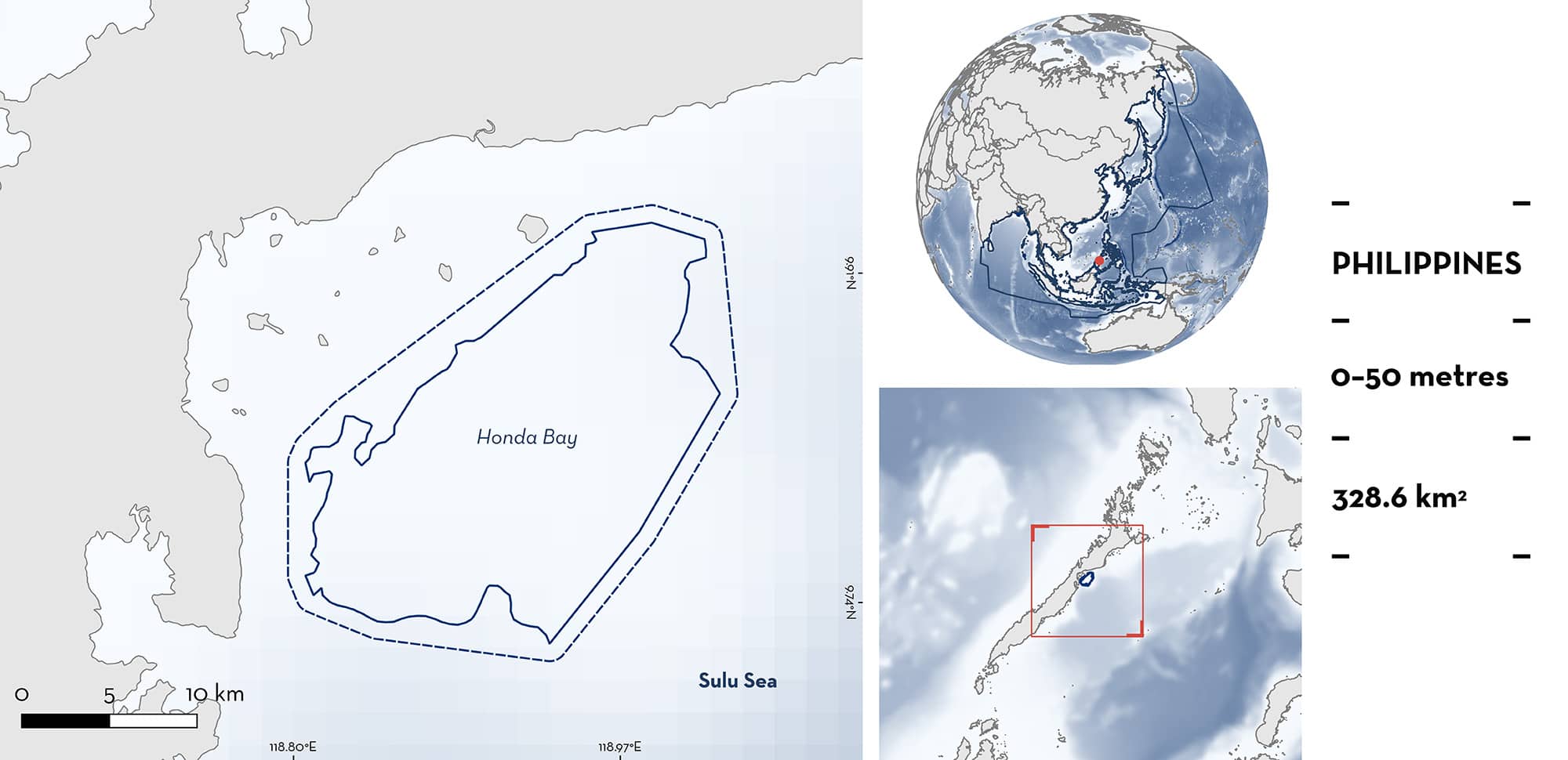
Honda Bay is located in the eastern side of mainland Palawan, in the northwestern Sulu Sea, southwestern Philippines. This area is relatively shallow and characterised by extensive shallow coral reef platforms, and surrounded by seagrass beds, sand cays, and mangrove swamps. Eight rivers drain into the bay. This area overlaps with the Sulu-Sulawesi Marine Ecoregion Ecologically or Biologically Significant Marine Area. Within this area there are: threatened species (e.g., Whale Shark Rhincodon typus) and feeding areas (e.g., Oceanic Manta Ray Mobula birostris).
Download factsheet
Honda Bay
DESCRIPTION OF HABITAT
Honda Bay is located in the eastern side of mainland Palawan and lies in the northwestern Sulu Sea, a deep basin (>4,000 m), in southwestern Philippines. The area is relatively shallow and presents extensive shallow coral reef platforms, and is surrounded by seagrass beds, sand cays, and mangrove swamps, forming part of the nearshore ecological system of the larger Sulu Sea marine ecosystem (Sandalo 1994). Eight rivers drain into the bay: Babuyan, Bacungan, Langogan, Magarwak, Tanabag, Tandayak, Tarabana, and Ulanguan.
The Sulu Sea has a tropical monsoon climate with two seasons each year: the dry (boreal winter) season that prevails from November to April, and the rainy (summer) season, extending from May to October (Wang et al. 2006). During the rainy season, the rivers discharge nutrients into Honda Bay, thereby increasing productivity.
This area overlaps with the Sulu-Sulawesi Marine Ecoregion Ecologically or Biologically Significant Marine Area (EBSA; CBD 2024).
This Important Shark and Ray Area is pelagic and is delineated from surface waters (0 m) to 50 m based on the depth range of the Qualifying Species in the area and the bathymetry of the area.
CRITERION A
VULNERABILITY
Two Qualifying Species considered threatened with extinction according to the IUCN Red List of Threatened Species regularly occur in the area. These are the Endangered Whale Shark (Pierce & Norman 2016) and Oceanic Manta Ray (Marshall et al. 2022).
CRITERION C
SUB-CRITERION C2 – FEEDING AREAS
Honda Bay is an important feeding area for one shark and one ray species.
From 2018 to 2023, Whale Sharks were recorded from April to October feeding on zooplankton, primarily sergestid shrimps (family Sergestidae), and small schooling fishes such as Philippine Anchovy Encrasicholina oligobranchus (Araujo et al. 2019; LAMAVE unpubl. data 2023). Feeding observations were often made in association with tuna feeding on baitfishes (Araujo et al. 2019). Surface feeding behaviour such as active ram filter feeding and vertical feeding have been observed by fishers, marine wildlife tour operators, and researchers (LAMAVE unpubl. data 2023). Sub-surface feeding behaviour such as passive feeding has also been observed by researchers and Whale Shark tour operator guests (LAMAVE unpubl. data 2023).
Honda Bay has been identified among the 25 largest aggregation sites for Whale Sharks globally (Araujo et al. 2022). This area is one of three known naturally occurring feeding sites for Whale Sharks in the Philippines, hosting a predominantly juvenile, male-dominated aggregation (Araujo et al. 2019, 2022; LAMAVE unpubl. data 2023). A total of ~428 individuals have been identified since 2018 from a combination of dedicated boat-based surveys and citizen science contributions (LAMAVE unpubl. data 2023). In a single season between April and October 2018, 117 individuals were identified from 507 shark encounters. Overall, 34% of individuals have been resighted in this area (Araujo et al. 2022). A mean of ~41 ± 13.5 Whale Sharks have been estimated to be present at any one time during the season within this area (Araujo et al. 2022).
Since 2018, Oceanic Manta Rays have been regularly and predictably observed in the area from April to October (Rambahiniarison et al. 2023; LAMAVE unpubl. data 2023). Individuals are seen feeding on zooplankton, primarily sergestid shrimps (Rambahiniarison et al. 2023; LAMAVE unpubl. data 2023). The main feeding strategy exhibited in this area is dominated by somersault or barrel roll feeding, followed by surface, straight, and sideways feeding (LAMAVE unpubl. data 2023).
Across the Philippines, sightings of devil rays were collated into a national database between 2004–2020, using in-water photographs and videos gathered from citizen science and dedicated research efforts (Rambahiniarison et al. 2023). This database includes 16 sites in which 205 sightings and 107 individual Oceanic Manta Rays have been recorded. Honda Bay is the site with the highest number of individuals recorded in the Philippines (68%, n = 73) (Rambahiniarison et al. 2023), with ~100 individuals identified to-date (LAMAVE unpubl. data 2023). Mostly females (n = 51) are seen with a total of 83 sightings in which 8 individuals have been resighted in this area (Rambahiniarison et al. 2023). Individual rays at this area have not been observed in other areas as no international match has been documented (LAMAVE unpubl. data 2023).
Download factsheet
SUBMIT A REQUEST
ISRA SPATIAL LAYER REQUEST
To make a request to download the ISRA Layer in either a GIS compatible Shapefile (.shp) or Google Earth compatible Keyhole Markup Language Zipped file (.kmz) please complete the following form. We will review your request and send the download details to you. We will endeavor to send you the requested files as soon as we can. However, please note that this is not an automated process, and before requests are responded to, they undergo internal review and authorization. As such, requests normally take 5–10 working days to process.
Should you have questions about the data or process, please do not hesitate to contact us.


