ISRA FACTSHEETS
ISRA FACTSHEETS
MEDITERRANEAN AND BLACK SEAS REGION
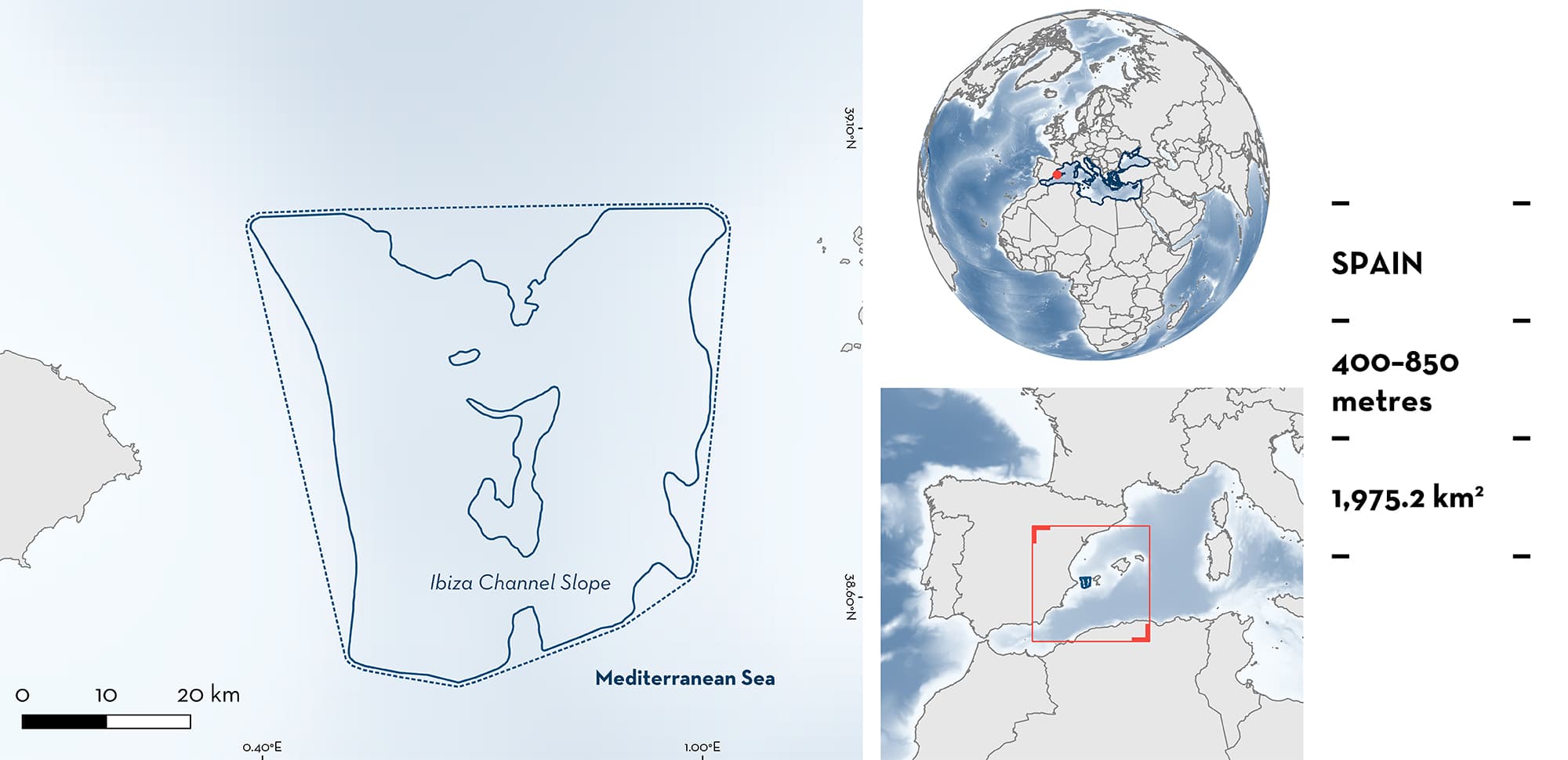
Ibiza Channel Slope
Summary
Ibiza Channel Slope is a deep channel connecting the Iberian Peninsula and the Balearic Islands promontory in Spain. The channel plays an important role in water exchange between the Balearic Basin and the Algerian Basin and thus promotes productivity. The dominant habitats are mud substrates with patches of rock and sand, with geological features such as the Xabia-Ibiza Seamount and pockmark fields. Within this area there are: reproductive areas (e.g., Bluntnose Sixgill Shark Hexanchus griseus).
Download factsheet
Ibiza Channel Slope
DESCRIPTION OF HABITAT
Ibiza Channel Slope is located between the Iberian Peninsula and the Balearic Islands in Spain. The area is an ~90 km wide deep (~700 m) channel that connects the Balearic Sea and Gulf of Lion with the Algerian Basin (García-Lafuente et al. 1995). It plays an important role in the dynamic water exchange between the northern basin (cooler and more saline with a mean sea surface temperature [SST] of 13.46ºC and salinity of 38.0 parts per thousand [ppt] in the boreal winter; and mean SST of 23.2ºC and salinity of 37.9 ppt in summer) and the Algerian Basin (warmer and less saline mean SST of 14.1ºC and salinity of 37.81 ppt in winter and mean SST of 24.9ºC and salinity of 37.5 ppt in summer). This is a highly dynamic area where the dominating southward current through this channel interacts with intrusions of recent Atlantic waters impulsed by the Alboran and Algerian Basin mesoscale structures flowing northward in the eastern part of the channel (Lana et al. 2016; Vargas-Yañez et al. 2017; Pinot et al. 2022). This interaction produces important oceanic fronts and upwellings, enhancing productivity in the area especially in the vicinity of the continental shelf and slope. The substrate is dominated by mud with patches of rock and sand (EEA 2021). The area is also characterised by distinct geological features such as the Xabia-Ibiza Seamount (Gomez-Ballestero et al. 2015) and pockmark fields (Acosta et al. 2001).
Ibiza Channel Slope overlaps in the North-western Mediterranean Pelagic Ecosystems Ecologically and Biologically Significant Marine Area (CBD 2016), and partially overlaps with the Plataforma-talud Marinos del Cabo de la Nao Key Biodiversity Area (KBA 2023), and one Natura 2000 area (EEA 2021).
This Important Shark and Ray Area is delineated from a depth of 400 m to 850 m based on the bathymetry of the area and the fisheries data supporting the Qualifying Species.
CRITERION C
SUB-CRITERION C1 – REPRODUCTIVE AREAS
Ibiza Channel Slope is an important reproductive area for two shark species.
Pregnant Little Sleeper Sharks represents most of the population of this species in the area. Overall, 32 Little Sleeper Shark specimens have been captured in benthic trawls targeting Red Shrimp (Aristeus antennatus) at depths between 500–800 m (captures by year: 1989–2003, n = 4; March 2013 – July 2016, n = 25; 2020, n = 1). All animals recorded were adult females. Laboratory analysis showed that 18 individuals (56.25%) where pregnant with macroscopically visible embryos, and the rest had recently ovulated with fertilised eggs (except one that was at the last ovulation stages) (Guallart et al. 2013, 2016; Guallart & García-Salinas 2015; Guallart & Ellis in prep.). Data highlight the high abundance of pregnant females as well as the unusual abundance of this species in Ibiza Channel, since worldwide there are only 62 reported records of Little Sleeper Shark up to 2023 (Guallart & Ellis in prep.).
The presence of neonate Bluntnose Sixgill Shark is regular and predictable in this area. A benthic trawling vessel based in Xàbia harbour that operates in the area at depths between 400–800 m was tasked with supplying 17 Bluntnose Sixgill Shark specimens for a genetic study. This fishing operation was able to achieve this in under two months. All the specimens captured measured 40–65 cm total length (TL) (J. Guallard pers. obs. 2013), corresponding to the size-at-birth for the species in the northwest Mediterranean Sea (55.6–68 cm TL; Capapé et al. 2004).
Download factsheet
SUBMIT A REQUEST
ISRA SPATIAL LAYER REQUEST
To make a request to download the ISRA Layer in either a GIS compatible Shapefile (.shp) or Google Earth compatible Keyhole Markup Language Zipped file (.kmz) please complete the following form. We will review your request and send the download details to you. We will endeavor to send you the requested files as soon as we can. However, please note that this is not an automated process, and before requests are responded to, they undergo internal review and authorization. As such, requests normally take 5–10 working days to process.
Should you have questions about the data or process, please do not hesitate to contact us.


