ISRA FACTSHEETS
ISRA FACTSHEETS
MEDITERRANEAN AND BLACK SEAS REGION
Marmara Sea Shelf
Summary
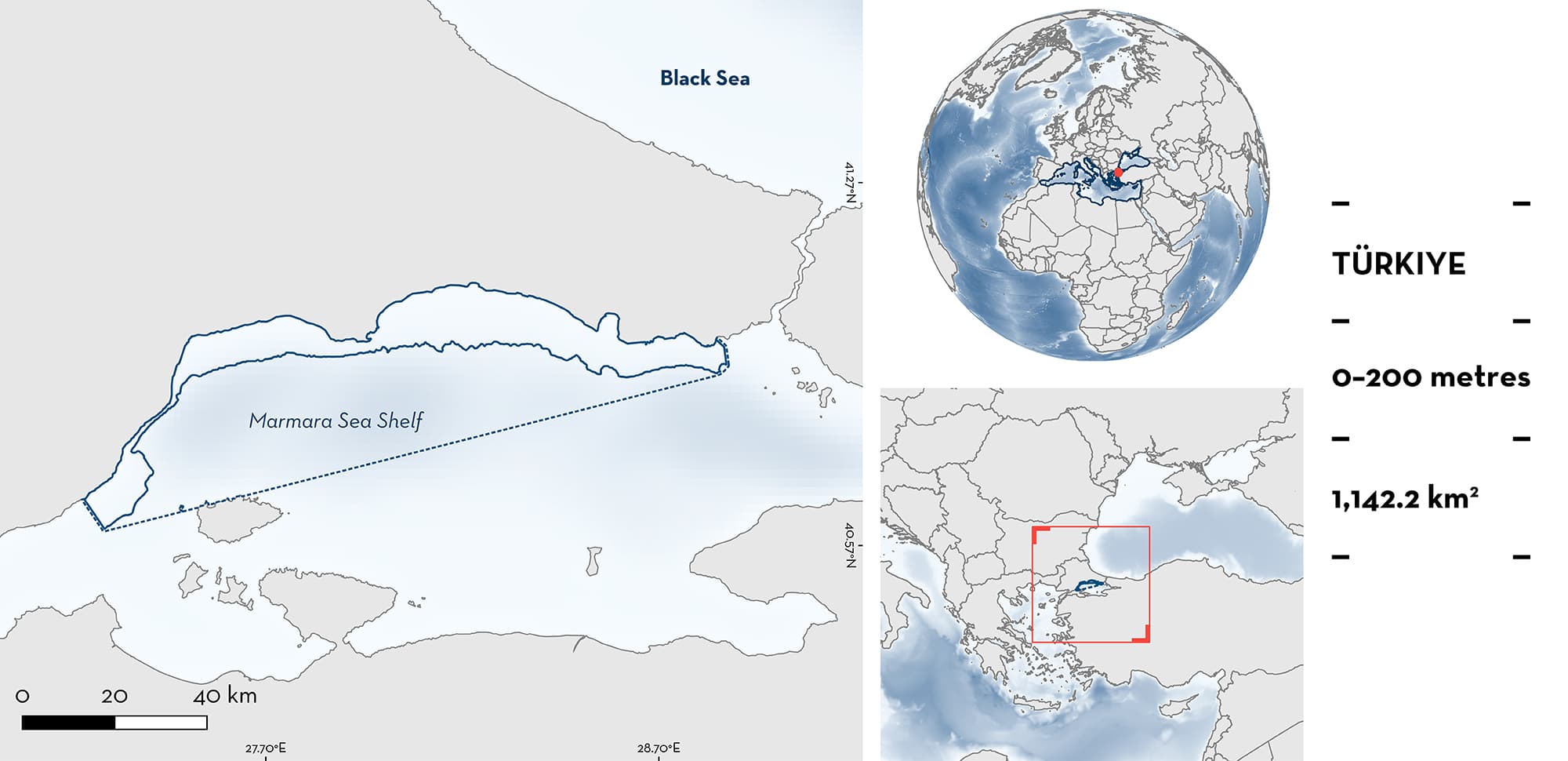
Marmara Sea Shelf is located in Türkiye, in the inland sea connecting the Black Sea and the Mediterranean Sea. The northern coastline is characterised by a narrow continental shelf and steep slope. The area consists mostly of sandy and muddy substrates. This area overlaps with three Key Biodiversity Areas. Within the area there are: threatened species (e.g., Common Smoothhound Mustelus mustelus) and feeding areas (e.g., Starry Smoothhound Mustelus asterias).
Download factsheet
Marmara Sea Shelf
DESCRIPTION OF HABITAT
Marmara Sea Shelf is located in Türkiye. The Marmara Sea is a small basin connecting the Mediterranean Sea and the Black Sea, through the Dardanelles and the Bosphorus Straits. In the southeastern part of the area there is the Marmara Archipelago, which includes Marmara, Avşa, Paşalimanı, and Ekinlik Islands. In addition, there are 17 other islands in the southern part of the area. The northern coastline is characterised by a narrow continental shelf and a steep slope, while the southern continental shelf is wide and reaches almost the centre of the area (Kabasakal 2023; Kabasakal et al. 2023).
The area is characterised by sandy and muddy substrates (Kabasakal & Karhan 2015; Kabasakal 2022). It shows a two-layer circulation pattern with opposite-flowing water masses. The upper layer is less saline and transports the water surplus of the Black Sea towards the Mediterranean Sea, whilst the lower more saline layer transports Aegean Sea water towards the Black Sea (Poulos 2020). Due to input from land sources, the area has high eutrophication and, below the haloclines, deoxygenation of the water occurs (Yalcin et al. 2017).
The area overlaps with three Key Biodiversity Areas: Marmara Islands, Kocaçay Delta, and Armutlu Peninsula (KBA 2023a, 2023b, 2023c).
This Important Shark and Ray Area is benthopelagic and is delineated from surface waters (0 m) to 200 m, based on the distribution of the Qualifying Species in the area.
CRITERION A
VULNERABILITY
Two Qualifying Species considered threatened with extinction according to the IUCN Red List of Threatened SpeciesTM regularly occur in the area. The Common Smoothhound is assessed as Endangered (Jabado et al. 2021) and the Starry Smoothhound as Vulnerable in a regional Mediterranean Sea assessment (Farrell et al. 2016).
CRITERION C
SUB-CRITERION C2 – FEEDING AREAS
Marmara Sea Shelf is an important feeding area for two shark species. Stomach content analysis and stable isotope analysis revealed the importance of the area, with δ15N values for both species enriched compared with values reported for the Mediterranean Sea, confirming that feeding occurs within the Marmara Sea (Gül & Demirel 2021).
Between 2017–2018, 18 Starry Smoothhounds were caught in benthic trawl surveys in the eastern part of the area at an average depth of 150 m (Gül & Demirel 2021). Stomach content analysis (88% of stomachs full) revealed that this species feeds mainly on Deep-water Rose Shrimp Parapenaeus longirostris (percentage index of relative importance [%IRI] = 88.4). This species has been reported to occur in higher abundances between 100–200 m mostly in the boreal autumn and winter (Daban et al. 2021).
Between 2017–2018, 28 Common Smoothhounds were caught in benthic trawl surveys, at an average depth of 89 m, mostly in the northern part of the area during autumn and winter. Stomach content analysis (95% of stomachs full) and stable isotope analysis revealed that the most important prey were the Harbour Crab Liocarnicus depurator (%IRI = 52.9) and the Deep-water Rose Shrimp (%IRI = 33.3) (Gül & Demirel 2021). Common Smoothhound has been reported to occur in higher abundances between 20–100 m in spring and summer (Daban et al. 2021). The Harbour Crab has been reported as an important discard of bivalve dredge fisheries (Colakoglu 2020) and the higher abundances in the Marmara Sea occur in autumn when abundances of Common Smoothhounds are also highest (Ayfer et al. 2017; Mulayim 2021). In addition, this crab is more abundant at similar depths (~100 m) as the Common Smoothhound (Koch & Duris 2016).
The Deep-water Rose Shrimp is the most abundant and most caught shrimp species in the Marmara Sea and has higher abundances in this location compared with other areas in Turkish waters (Bayhan & Akkaya 2005; İnceoğlu et al. 2021). Higher biomass and relative abundances were reported between 50–200 m and during summer and autumn (Bayhan & Akkaya 2005; İnceoğlu et al. 2021). This pattern matches with the occurrence of both smoothhound species, indicating that both species take seasonal advantage of the high biomass of this prey within the area to feed.
Download factsheet
SUBMIT A REQUEST
ISRA SPATIAL LAYER REQUEST
To make a request to download the ISRA Layer in either a GIS compatible Shapefile (.shp) or Google Earth compatible Keyhole Markup Language Zipped file (.kmz) please complete the following form. We will review your request and send the download details to you. We will endeavor to send you the requested files as soon as we can. However, please note that this is not an automated process, and before requests are responded to, they undergo internal review and authorization. As such, requests normally take 5–10 working days to process.
Should you have questions about the data or process, please do not hesitate to contact us.


