ISRA FACTSHEETS
ISRA FACTSHEETS
ASIA REGION
Nago Bay
Summary
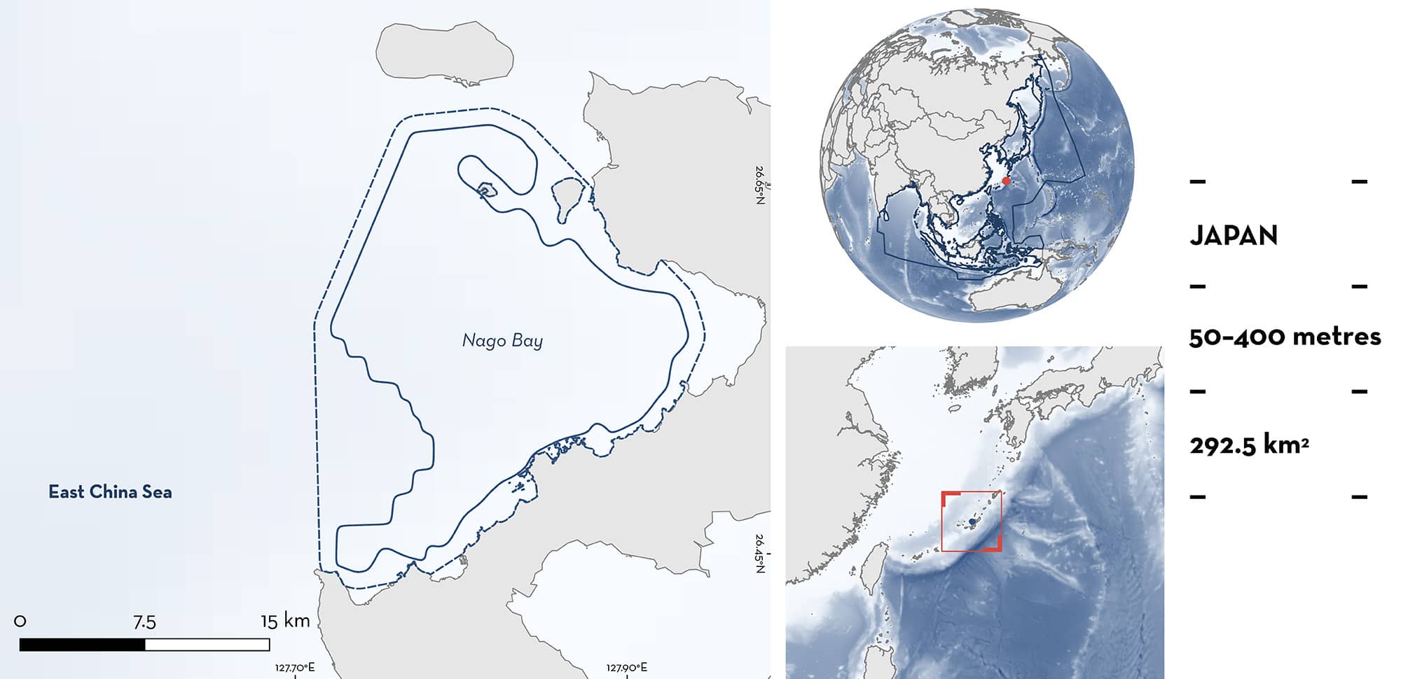
Nago Bay is located off the central western coast of Okinawa Island in southern Japan. This area is situated in the subtropics and is comprised of a fringing reef which leads to an abrupt drop-off and descends into a submarine terrace. This terrace, characterised by sandy and muddy substrates with sporadic smaller deep-sea coral assemblages, forms a unique, narrow benthic habitat. Strong currents influenced by the Kuroshio Current are prevalent in this area, adding dynamic oceanographic complexity to this region. This area overlaps with the Southwest Islands Ecologically or Biologically Significant Marine Area. Within this area there are: threatened species and reproductive areas (Japanese Shortnose Spurdog Squalus brevirostris).
Download factsheet
Nago Bay
DESCRIPTION OF HABITAT
Nago Bay is located off the central western coast of Okinawa Island in southern Japan. This area lies in the subtropics and is composed of a fringing reef, extending 700–1,600 m wide, which leads to an abrupt drop-off and descends into a submarine terrace (Sinniger et al. 2022). This terrace, characterised by sandy and muddy substrates with sporadic smaller deepsea coral assemblages, forms a unique, narrow benthic habitat. Minna Island, situated in the northern part of this area, is a small atoll spanning less than 0.5 km2. Located ~7 km west of the Motobu Peninsula, this island rises to an elevation of only 12 m. The seafloor around Minna Island experiences a drop-off immediately beyond the fringing reef to ~100 m depth, creating a transition from shallow coral environments to the deeper marine ecosystem.
Strong currents influenced by the Kuroshio Current are prevalent in this area, adding dynamic oceanographic complexity to this region. Weak southerly winds are dominant in the boreal summer, while stronger northeasterly winds are dominant in winter (Singh et al. 2022). Typhoons generally occur between May and October (Singh et al. 2022).
This area partly overlaps with the Southwest Islands Ecologically or Biologically Significant Marine Area (EBSA; CBD 2024).
This Important Shark and Ray Area is benthopelagic and subsurface and is delineated from 50 m to 400 m based on the depth range of Qualifying Species in the area.
CRITERION A
VULNERABILITY
One Qualifying Species within the area is considered threatened with extinction according to the IUCN Red List of Threatened Species. The Japanese Shortnose Spurdog is assessed as Endangered (Rigby et al. 2021).
CRITERION C
SUB-CRITERION C1 – REPRODUCTIVE AREAS
Nago Bay is an important reproductive area for one shark species.
Since 2022 in February, March, April, and September, sampling conducted at depths between 300–400 m, using deep-sea fishing rods with five hooks and line has captured 53 Japanese Shortnose Spurdogs (female = 37, male = 16) (F Ziadi-Künzli unpubl. data 2024). From the total number of adult females (n = 26), 88.5% were pregnant. Most pregnant females (n = 19) were in an advanced state carrying two embryos each, with embryo sizes ranging from 12.6 to 17.8 cm total length (TL). Size-at-birth is ~20 cm TL (Viana & de Carvalho 2020). Four females had yolk in the candle stage (early pregnancy). Thus, this area is important for their gestation. In other areas it has been determined that this species is spatially segregated over the continental slope, and body-length and sex-ratio distributions suggested that there is a maturity-based segregation (Yano et al. 2020).
The Japanese Shortnose Spurdog is the most commonly found deepsea shark species in this area (F Ziadi-Künzli unpubl. data 2024). Along its distribution, few studies have reported pregnant females and in low numbers (Viana & de Carvalho 2020; Yano et al. 2020). Two embryos from this species were reported in Japan waters without specifying the location (Viana & de Carvalho 2020). The most comprehensive of these studies collected 90 Japanese Shortnose Spurdogs using 1,503 bottom trawls during May and June in 2000–2005 and 2008–2014 in eastern China Sea, with only one pregnant female captured (Yano et al. 2020).
Download factsheet
SUBMIT A REQUEST
ISRA SPATIAL LAYER REQUEST
To make a request to download the ISRA Layer in either a GIS compatible Shapefile (.shp) or Google Earth compatible Keyhole Markup Language Zipped file (.kmz) please complete the following form. We will review your request and send the download details to you. We will endeavor to send you the requested files as soon as we can. However, please note that this is not an automated process, and before requests are responded to, they undergo internal review and authorization. As such, requests normally take 5–10 working days to process.
Should you have questions about the data or process, please do not hesitate to contact us.


