ISRA FACTSHEETS
ISRA FACTSHEETS
NEW ZEALAND & PACIFIC ISLANDS REGION
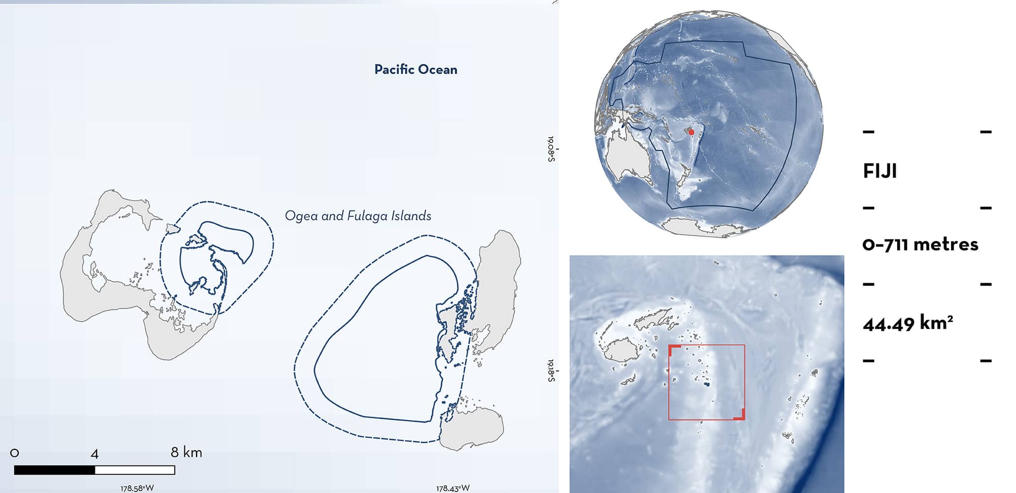
Ogea and Fulaga Islands
Summary
Ogea and Fulaga Islands is located in the southeast of the Lau group of islands in Fiji. This area is characterised by lagoons, large barrier reef systems, reef passes, shallow reef crests, steep reef drop-offs, and pelagic waters. It overlaps with the Kadavu and the Southern Lau Region Ecologically or Biologically Significant Marine Area. Within this area there are: threatened species, feeding areas, and undefined aggregations (Reef Manta Ray Mobula alfredi).
Download factsheet
Ogea and Fulaga Islands
DESCRIPTION OF HABITAT
Ogea and Fulaga Islands is located in the Lau group of islands in Fiji. This split area includes one part around Ogea Island and another part around Fulaga Island. Ogea Island is surrounded by a large lagoon enclosed by barrier reef systems and connected to the ocean by several channels. Fulaga Island also has a lagoon with a single main channel connecting it to the ocean. This area includes parts of the lagoons, the channels, and pelagic waters outside of the channel at both islands. Habitats are characterised by shallow lagoons, reef flats, shallow reef crests, forereef slopes, coral pinnacles, deep wall drop-offs, and pelagic waters (L Gordon pers. obs. 2024). Steep drop-offs rapidly reach depths of >1,000 m which causes strong currents to run along the reef system (L Gordon pers. obs. 2024). Currents are also influenced by the tidal cycle.
This area overlaps with the Kadavu and the Southern Lau Region Ecologically or Biologically Significant Marine Area (EBSA; CBD 2024).
This Important Shark and Ray Area is benthic and pelagic and is delineated from surface waters (0 m) to 711 m based on the global depth range of the Qualifying Species.
CRITERION A
VULNERABILITY
One Qualifying Species considered threatened with extinction according to the IUCN Red List of Threatened Species regularly occurs in the area. This is the Vulnerable Reef Manta Ray (Marshall et al. 2022).
CRITERION C
SUB-CRITERION C2 – FEEDING AREAS
Ogea and Fulaga Islands is an important feeding area for one ray species.
Between 2017–2024, drone surveys comprising of 10–15 flights (25 min duration) per annual visit were conducted at Fulaga Island. These recorded Reef Manta Rays feeding in the area (MV Erdmann pers. obs. 2024). Surveys were conducted in March (2023, 2024), July (2018, 2019), and September (2017, 2020, 2022). Feeding Reef Manta Rays were recorded on every flight within the lagoon, the channel, and around the seaward side of the channel entrance (MV Erdmann & S Meo pers. obs. 2024). Between 3–9 individuals were recorded per flight, with an average of 3–6 individuals per survey per year. Community consultations during surveys revealed that aggregations of >5 Reef Manta Rays are regularly observed feeding in this area between March–November (MV Erdmann & S Meo pers. obs. 2024). Feeding Reef Manta Rays were also recorded during nine of 11 drone flights at Ogea Island. Additionally, two satellite tags on Reef Manta Rays recorded data between August and November 2023 before detaching. These satellite tags only transmit a location when the tag breaches the surface, which typically only occurs when Reef Manta Rays surface feed (MV Erdmann pers. obs. 2024). Most tag locations were within the area, with additional transmissions on the southwest of Fulaga Island, outside the area, which could not be visually surveyed due to heavy southeasterly swells (M VErdmann pers. obs. 2024).
CRITERION C
SUB-CRITERION C5 – UNDEFINED AGGREGATIONS
Ogea and Fulaga Island is an important area for undefined aggregations of one ray species.
Between 2022–2024, a total of 13 Reef Manta Ray sightings were recorded of 11 individuals on six different survey days at Ogea Island (Gordon 2023; Manta Project Fiji unpubl. data 2024). Reef Manta Rays were sighted on 100% of survey days. Local ecological knowledge indicates that Reef Manta Rays have long been present in the area before sporadic surveys began (MV Erdmann pers. obs. 2024). Reef Manta Rays aggregate in the area to visit cleaning stations. Annual surveys from 2017–2024 conducted 2–4 dives per visit at Ogea Island in the area (MV Erdmann pers. obs. 2024). Divers recorded between 1–6 Reef Manta Rays at the cleaning stations on every dive (MV Erdmann & S Meo pers. obs. 2024). On 11 drone flights (25-minute duration each) over the Ogea Lagoon during six visits in 2017, 2022, and 2023, 3–10 Reef Manta Rays were observed on every flight. Cleaning activity at cleaning stations on the reef crest on Ogea was observed on seven of 11 flights. At cleaning stations, small reef fishes remove parasites and dead tissue from Reef Manta Rays (Armstrong et al. 2021). In this area, there are four main species which clean Reef Manta Rays: Bluestreak Cleaner Wrasse Labroides dimidiatus, Bicolor Cleaner Wrasse Labroides bicolor, Moon Wrasse Thalassoma lunare, and Blunthead Wrasse Thalassoma amblycephalum (L Gordon pers. obs. 2023).
Download factsheet
SUBMIT A REQUEST
ISRA SPATIAL LAYER REQUEST
To make a request to download the ISRA Layer in either a GIS compatible Shapefile (.shp) or Google Earth compatible Keyhole Markup Language Zipped file (.kmz) please complete the following form. We will review your request and send the download details to you. We will endeavor to send you the requested files as soon as we can. However, please note that this is not an automated process, and before requests are responded to, they undergo internal review and authorization. As such, requests normally take 5–10 working days to process.
Should you have questions about the data or process, please do not hesitate to contact us.


