ISRA FACTSHEETS
ISRA FACTSHEETS
CENTRAL AND SOUTH AMERICAN PACIFIC REGION
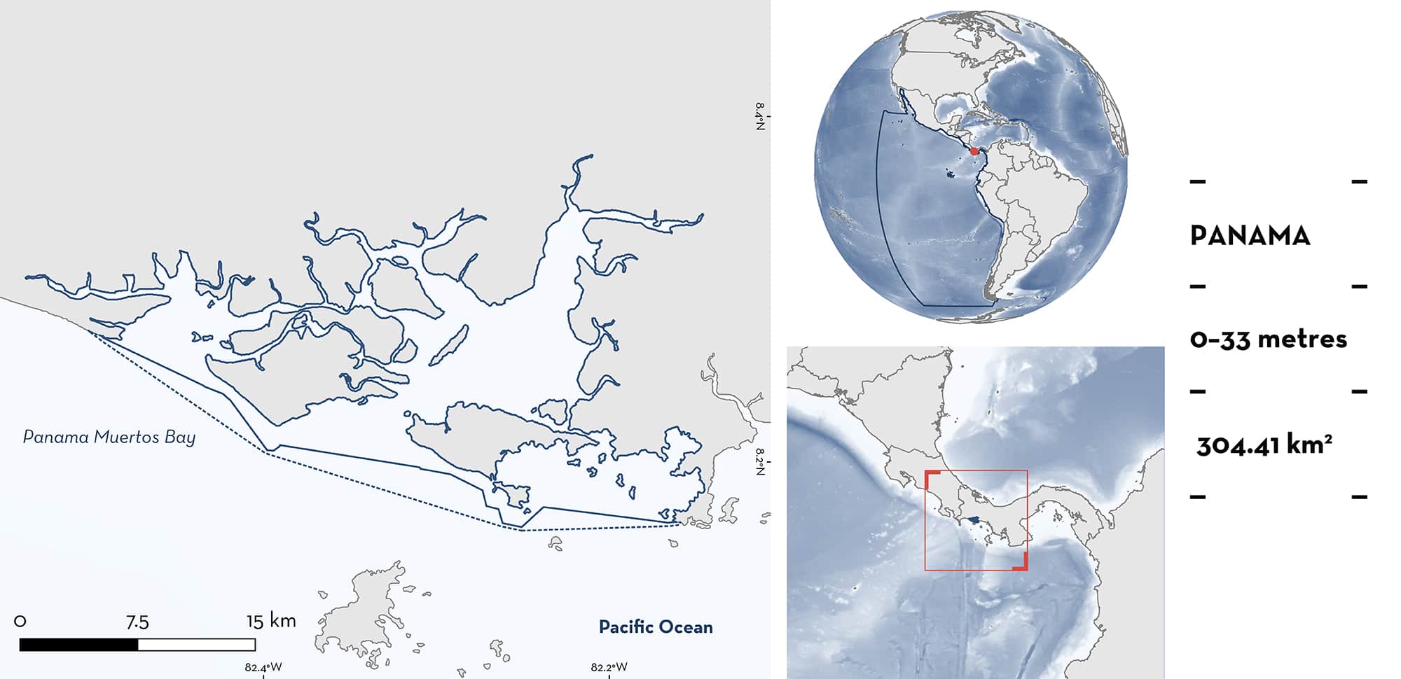
Panama Muertos Bay
Summary
Panama Muertos Bay is a large estuarine and riverine area within the Gulf of Chiriquí in western Pacific Panama. It partially falls within the Eastern Tropical Pacific Marine Corridor Ecologically or Biologically Significant Marine Area (EBSA). The area has a diversity of marine, estuarine, and freshwater habitats including sandy beaches, mudflats, islands, rivers, and importantly, extensive mangrove forests in good ecological condition. The area is primarily shallow (<10 m depth) with large areas of exposed mudflats at low tide. Within this area there are: threatened species (e.g., Bonnethead Shark Sphyrna tiburo) and reproductive areas (e.g., Pacific Smalltail Shark Carcharhinus cerdale).
Download factsheet
Panama Muertos Bay
DESCRIPTION OF HABITAT
Panama Muertos Bay is a large estuarine and riverine system in the Gulf of Chiriquí, western Pacific Panama. Situated within the Pacific Central-American Coastal Large Marine Ecosystem, the area has a diversity of marine, estuarine, and freshwater habitats including sandy beaches, mudflats, islands, rivers, swamp forests, and importantly, extensive mangrove forests in good ecological condition. The broader Gulf of Chiriquí has > 380 km2 of mangroves, the second largest area of mangroves in Panama. Mangrove diversity is high and includes the Red Mangrove species Rhizophora mangle and R. racemosa, Button Mangrove Conocarpus erectus, Black Mangrove Avicennia germinans, and White Mangrove Laguncularia racemosa. The area includes most of the Refugio de Vida Silvestre Playa la Barqueta Agricola and a small portion of the Parque Nacional Marino Golfo de Chiriquí. The area partially falls within the Eastern Tropical Pacific Marine Corridor Ecologically or Biologically Significant Marine Area (SCBD 2022) and partially overlaps with the David Mangroves Key Biodiversity Area (KBA 2022). The area is mostly shallow water (< 10 m) but with deeper channels to 33 m depth (Navionics 2022).
This Important Shark and Ray Area is delineated from surface and inshore waters (0 m) to 33 m depth based on the bathymetry of the area (Navionics 2022).
CRITERION A
VULNERABILITY
Four Qualifying Species considered threatened with extinction according to the IUCN Red List of Threatened Species™ regularly occur in the area. These are the Critically Endangered Pacific Smalltail Shark (Pollom et al. 2020) and Scalloped Hammerhead (Rigby et al. 2019), Endangered Bonnethead Shark (Pollom et al. 2021), and Vulnerable Blacktip Shark (Rigby et al. 2021).
CRITERION C
SUB-CRITERION C1 – REPRODUCTIVE AREAS
Panama Muertos Bay is an important reproductive area for four shark species. The area has been identified as a nursery area based on interviews with fishers and artisanal fishery monitoring (Robles et al. 2015; López-Angarita et al. 2021b).
Scalloped Hammerhead was the most recorded shark species in artisanal fisheries monitoring, representing 49.2% of the catch. Size ranged 33.5–256 cm total length (TL) with an average of 60.4 ± 19 cm (n = 705). Neonates and young-of-the-year (< 75 cm TL), which represented most of the catch, were recorded in all sampling months (with a peak in March), supporting the use of the area as a nursery area (Robles et al. 2015). The reported size-at-birth of Scalloped Hammerhead in the Eastern Pacific includes 47–55 cm TL for Ecuador (Estupiñán-Montaña et al. 2021), although sizes captured in Panama Muertos Bay suggest a smaller size-at-birth locally. Pacific Smalltail Shark was the second most recorded shark, representing 33.1% of the catch. Size ranged 30.4–107.5 cm TL with an average of 43.7 ± 7.5 cm (n = 475). Only one adult was caught with the catch being dominated by small size classes representing neonates and young-of-the-year (Robles et al. 2015). The reported size-at-birth of Pacific Smalltail Shark is >30 cm TL (based on the size of near-term embryos; Castro 2011).
Blacktip Shark represented 5.6% of the catch. Size ranged 43.0–78.2 cm TL with an average of 68.7 cm TL (n = 80) (Robles et al. 2015). Panama Muertos Bay catches of Blacktip Shark were dominated by neonate and young-of-the-year with their sizes mostly within the size-at-birth range of 38–72 cm TL (Ebert et al. 2021).
Bonnethead Shark represented 6.4% of the catch. Size ranged 34.0–118.5 cm TL with an average of 60.8 cm TL (n = 92) and the highest catch frequency in the size range 45–70 cm TL. A gravid female was caught in April (although data are not available for all months to fully understand the seasonality of reproduction in the area) (Robles et al. 2015). Bonnethead Shark size-at-birth is 22–30 cm TL (Lombardi-Carlson et al. 2003) and 23–24 cm TL (Ulrich et al. 2007), both from the Western Atlantic and young-of-the-year range in size 31–55 cm TL (Western Atlantic; Carlson & Parsons 1997). While no neonate sized animals were caught during the Panama Muertos Bay study, there was considerable overlap with reported young-of-the-year size .
Download factsheet
SUBMIT A REQUEST
ISRA SPATIAL LAYER REQUEST
To make a request to download the ISRA Layer in either a GIS compatible Shapefile (.shp) or Google Earth compatible Keyhole Markup Language Zipped file (.kmz) please complete the following form. We will review your request and send the download details to you. We will endeavor to send you the requested files as soon as we can. However, please note that this is not an automated process, and before requests are responded to, they undergo internal review and authorization. As such, requests normally take 5–10 working days to process.
Should you have questions about the data or process, please do not hesitate to contact us.


