ISRA FACTSHEETS
ISRA FACTSHEETS
POLAR WATERS REGION
Pangnirtuup Kangiqtualua
Summary
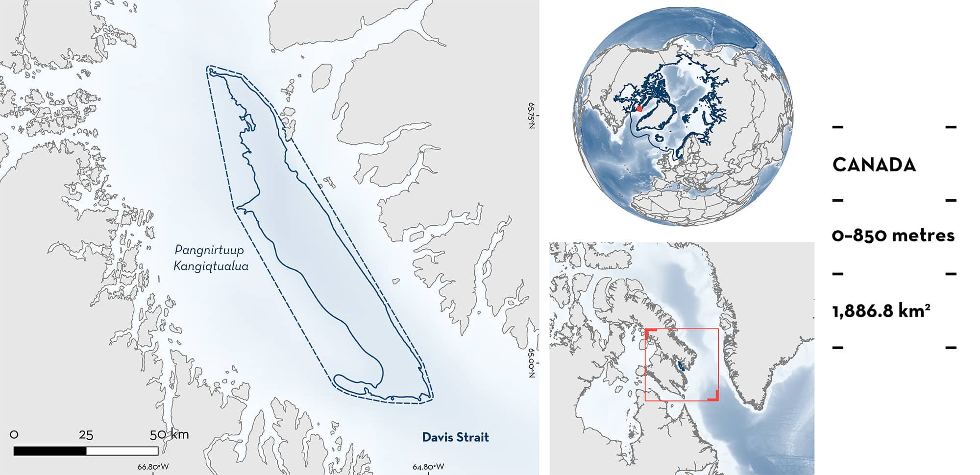
Pangnirtuup Kangiqtualua, also known as Cumberland Sound, is a large embayment located in Nunavut, Canada. The area is situated within a fjord, which functions as a semi-closed marine ecosystem, and the substrate is dominated by soft muds. Within the area there are: threatened species and feeding areas (Greenland Shark Somniosus microcephalus).
Download factsheet
Pangnirtuup Kangiqtualua
DESCRIPTION OF HABITAT
Pangnirtuup Kangiqtualua, also known as Cumberland Sound, is located within a large embayment of the same name situated in Nunavut, Canada. This embayment is ~80 km wide by 250 km long with a 300 m deep sill and maximum depths of >1,400 m. It receives freshwater input from the Duval River, melting permafrost, and upland glaciers (McMeans et al. 2015). The area is located within a fjord, which functions as a semi-closed marine ecosystem and the substrate is dominated by soft mud.
Currents carrying water from both the Arctic and Atlantic Oceans cross the opening of the sound. This is particularly important during the winter when water temperature and salinity increase (Bedard 2019). While its relatively shallow sill blocks most of the water column, the influx of dense, oxygen-rich mixed shelf water prevents deep water hypoxia. A kilometre below the depth of the sill, a permanent population of Greenland Halibut Reinhardtius hippoglossoides resides (Bedard 2019).
This Important Shark and Ray Area is benthopelagic and is delineated from the surface (0 m) to a depth of 850 m based on the depth range of Qualifying Species in the area.
CRITERION A
VULNERABILITY
One Qualifying Species considered threatened with extinction according to the IUCN Red List of Threatened Species regularly occurs in the area. This is the Vulnerable Greenland Shark (Kulka et al. 2020).
CRITERION C
SUB-CRITERION C2 – FEEDING AREAS
Pangnirtuup Kangiqtualua is an important feeding area for one shark species.
Between 2007–2009, a scientific survey in Cumberland Sound captured 51 Greenland Sharks to analyse the impact of food web structure on total mercury (THg) levels in the sharks. Stomach contents were identified, and the Greenland Halibut was the most commonly consumed fish, present in 52.9% of stomachs (McMeans et al. 2015). Greenland Halibut is also linked as a key prey item of Greenland Sharks in this area according to local ecological knowledge (LEK) (Inuit Qauijimajatuqangit) (Idrobo & Berkes 2012). Evidence from other regions also indicates the importance of Greenland Halibut in the diet of this species and highlights that Greenland Sharks target prey that is highly abundant in a given system (Nielsen et al. 2019).
Pangnirtuup Kangiqtualua is known for its high biomass and stable catches of Greenland Halibut, making it the only community-based commercial fishery in the inshore region of Eastern Baffin Island and enabling a small-scale winter fishery for the species (DFO 2008). The fishery has been active during the boreal winter (January–May) when land-fast ice allows access to deep water (>400 m) which is the preferred habitat of Greenland Halibut (DFO 2008).
Based on reported catches from the Greenland Halibut fishery, the incidental catch of Greenland Shark in the winter between 1987–2006 ranged between 0.4 to 2.9 sharks per 1,000 hooks (mean = 1.1/1,000 hooks). During an experimental longline fishery for Greenland Halibut during the ice-free season in 2009 at 256–1,189 m (most >800 m) the incidental catch of Greenland Shark was found to increase substantially (i.e., 6.3/1,000 hooks) (Young 2010; Grant et al. 2018). The seasonality of these catch rates was confirmed by LEK indicating higher numbers of Greenland Sharks observed earlier in the fishing season (November and December), followed by a no-shark period lasting until the end of March, and terminated by a sudden resurgence lasting until the end of the fishing season in May (Idrobo & Berkes 2012). A satellite tagging (pop-up satellite archival tags; PSATs) study supports this movement pattern and highlights the period when four of 11 tagged sharks (243–325 cm total length [TL]) left the sound by late fall/early winter (Campana et al. 2015). This supports the notion that Greenland Sharks use this area as a feeding ground during the ice-free period.
During 2010 and 2011, a PSAT tagging study of Greenland Sharks and Greenland Halibut in this area, revealed that although tagged Greenland Sharks (300–320 cm TL) spent most of their time at 800–900 m, they dove and spent short periods of time (>1 hour) at depths >1,050 m where Greenland Halibut were predominantly detected suggesting that those dives were to feed on Greenland Halibut (Madigan et al. 2022).
Offshore of the sound, Davis Strait is known as a spawning ground of Greenland Halibut which is thought to occur between December and March (Gundersen et al. 2010). This suggests that fish could migrate from this location to Davis Strait in the winter. The use of this area as a feeding ground for the Greenland Shark could be associated with higher biomass of the prey during the ice-free period.
Download factsheet
SUBMIT A REQUEST
ISRA SPATIAL LAYER REQUEST
To make a request to download the ISRA Layer in either a GIS compatible Shapefile (.shp) or Google Earth compatible Keyhole Markup Language Zipped file (.kmz) please complete the following form. We will review your request and send the download details to you. We will endeavor to send you the requested files as soon as we can. However, please note that this is not an automated process, and before requests are responded to, they undergo internal review and authorization. As such, requests normally take 5–10 working days to process.
Should you have questions about the data or process, please do not hesitate to contact us.


