ISRA FACTSHEETS
ISRA FACTSHEETS
WESTERN INDIAN OCEAN REGION
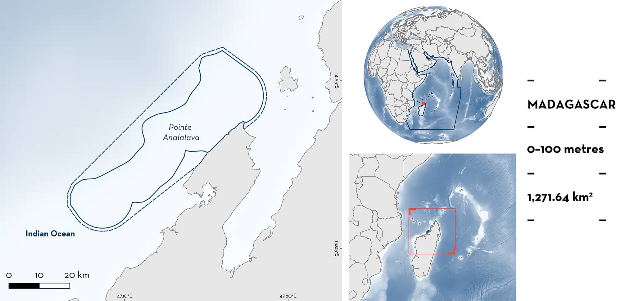
Pointe Analalava
Summary
Pointe Analalava is located in northwest Madagascar. The area is characterised by a diverse range of habitats including coral reefs, seagrass meadows, mangrove ecosystems, and pelagic waters. The area is situated in shelf waters and overlaps with two Ecologically or Biologically Significant Marine Areas: Northern Mozambique Channel and Mozambique Channel. Within this area there are: threatened species and undefined aggregations (Whale Shark Rhincodon typus).
Download factsheet
Pointe Analalava
DESCRIPTION OF HABITAT
Pointe Analalava is located in northwest Madagascar. This area encompasses mostly shallow reefs, next to a deep shelf, with the habitat composed of sandy substrate, reefs, mangroves, seagrass patches, and pelagic waters (Metcalf et al. 2007). Bays within this area are known to become nutrient-rich seasonally when the sea surface temperature rises (September–December) (Pripp et al. 2014).
The area overlaps with two Ecologically or Biologically Significant Marine Areas (EBSAs): Mozambique Channel (CBD 2023a) and Northern Mozambique Channel (CBD 2023b).
This Important Shark and Ray Area is pelagic and is delineated from inshore and surface waters (0 m) to 100 m based on the bathymetry of the area.
CRITERION A
VULNERABILITY
The one Qualifying Species within the area is considered threatened with extinction according to the IUCN Red List of Threatened SpeciesTM. The Whale Shark is assessed as Endangered (Pierce & Norman 2016).
CRITERION C
SUB-CRITERION C5 – UNDEFINED AGGREGATIONS
Pointe Analalava is an important area for undefined aggregations of one shark species.
Eight Whale Sharks were tagged around Nosy Be with SPOT5 satellite tags in 2016 (Diamant et al. 2018). Four of the sharks (50%) made movements to the south along the west coast of Madagascar where kernel density estimates revealed a Whale Shark activity hotspot ~180 km to the southeast near Pointe d’Analalava. In addition to tagged animal space use, this area was also identified as an important area for Whale Sharks through interview surveys of fishers and dive operators in the area, who indicated that this area is consistently used by Whale Sharks across years (Jonahson & Harding 2007). Combined, this information provides evidence for Pointe Analalava as an important area for Whale Sharks, however the nature and function of this aggregation remains unknown.
Download factsheet
SUBMIT A REQUEST
ISRA SPATIAL LAYER REQUEST
To make a request to download the ISRA Layer in either a GIS compatible Shapefile (.shp) or Google Earth compatible Keyhole Markup Language Zipped file (.kmz) please complete the following form. We will review your request and send the download details to you. We will endeavor to send you the requested files as soon as we can. However, please note that this is not an automated process, and before requests are responded to, they undergo internal review and authorization. As such, requests normally take 5–10 working days to process.
Should you have questions about the data or process, please do not hesitate to contact us.


