ISRA FACTSHEETS
ISRA FACTSHEETS
MEDITERRANEAN AND BLACK SEAS REGION
Southeastern Aegean Sea
Summary
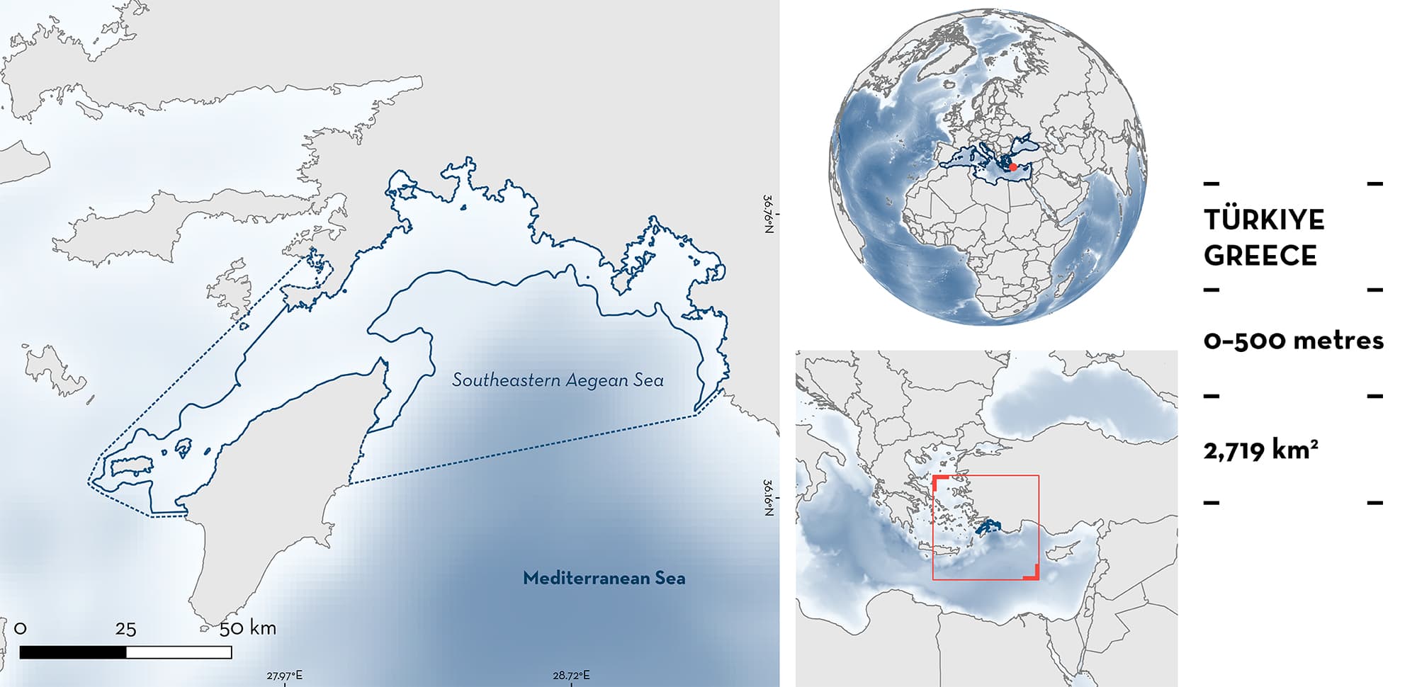
Southeastern Aegean Sea is located between Greece and Türkiye. On the Greek side, it includes Northwest Rhodes Island and its small islets, the strait of Rhodos, and continues south to Aphantou. On the Turkish side, the area extends from Oludeniz Bay in Fethiye, to Datça Peninsula. The area is characterised by diverse coastal and benthic habitats, including a subtropical open sea environment and bays, sandy to muddy substrates, rocky shores, islets, and rivers that flow into the bays. The area overlaps with five Natura 2000 sites, two Key Biodiversity Areas, and an Ecologically or Biologically Significant Marine Area. Within this area there are: threatened species (e.g., Smoothback Angelshark Squatina oculata); reproductive areas (Smoothback Angelshark); and undefined aggregations (Sandbar Shark Carcharhinus plumbeus).
Download factsheet
Southeastern Aegean Sea
DESCRIPTION OF HABITAT
Southeastern Aegean Sea is located between Greece and Türkiye. On the Greek side, it includes Northwest Rhodes Island and its small islets, the strait of Rhodos in the north, and it continues south to Aphantou on the east. On the Turkish side, the area extends from Oludeniz Bay in Fethiye, to Datça Peninsula. The area is characterised by benthic habitat that consists mostly of sandy to muddy substrates (Vasquez et al. 2021). The waters are oligotrophic compared to the North Aegean Sea and there is an open sea subtropical environment influenced by the Levantine Sea (Sini et al. 2017). The continental shelf is narrow with the slope starting close to the coast.
The area overlaps with five Natura 2000 sites (GR4210026, GR4210024, GR4210005, GR4210025, GR4210030), two Key Biodiversity areas (Datça and Bozburun Peninsula, and Chalki Island and surrounding islets), and the Central Aegean Ecologically or Biologically Significant Marine Area. Additionally, Fethiye-Gocek Bay was listed as a Specially Protected Area under the Barcelona Convention in 1988 (Kaboğlu et al. 2005).
This Important Shark and Ray Area is benthopelagic and is delineated from the surface (0 m) to 500 m depth based on the known depth range of the Qualifying Species in the area.
CRITERION A
VULNERABILITY
Two Qualifying Species considered threatened with extinction according to the IUCN Red List of Threatened SpeciesTM regularly occur in the area. These are the Critically Endangered Smoothback Angelshark (Morey et al. 2019) and the Endangered Sandbar Shark (Rigby et al. 2021).
CRITERION C
SUB-CRITERION C1 – REPRODUCTIVE AREAS
Southeastern Aegean Sea is an important reproductive area for one shark species.
This area hosts a population of Smoothback Angelsharks that are no longer connected to the global population (Lawson et al. 2020; Gordon 2022). According to fisheries-dependent data, the habitat used by this species in the area is between 30–300 m. Prior to recent discoveries in this area, records of Smoothback Angelsharks in published literature from Turkish waters show approximately one record per year (Ergüden et al. 2019; Giovos et al. 2022; Özgür and Kabakasal 2022). Since December 2022, they have been encountered in nearly every fishing trial conducted in this region. Additionally, since 2020, 25 adult Smoothback Angelshark records have been confirmed from Fethiye Bay (A. Ulman unpubl. data 2023), in addition to one large adult from adjacent Oludeniz Bay. Fifty percent of sexed adults were females (A. Ulman unpubl. data 2023). Fifteen of those individuals were caught in 2023 alone, including three gravid females that were caught by trammel net. Two of them were carrying three pups and the third was carrying five, all of which were aborted onboard the vessel. The first three (~8–10 cm total length [TL]) were dead with external yolk sacs, the next eight (~12–20 cm TL) were released alive with the females (69.6 cm and unknown TL). Published size-at-birth for this species is 22–35 cm TL (Capapé et al. 2002, 2005). Females have been caught in a range of sizes including young-of-the-year (YOY) to mature females from 37 cm to 150 cm TL (A. Ulman unpubl. data 2023).
CRITERION C
SUB-CRITERION C5 – UNDEFINED AGGREGATIONS
Southeastern Aegean Sea is important for aggregations of one shark species.
Groups of four to seven adult Sandbar Sharks (undetermined sexes) have been repeatedly seen throughout the month of May in 2019, 2020, and 2021, and July 2023 in shallow waters (5–10 m) in Dalaman Bay, Türkiye (H Filiz unpub. data 2023). According to two local fishers, groups of over 100 Sandbar Sharks were regularly observed in 3–5 m depths in Fethiye and Oludeniz Bays up until 1990 (O. Kavunaki and R. Aybi pers. comm. 2023). Additionally, Greek recreational fishers report captures of up to 100 neonate individuals every year (Naasan Aga – Spyridopoulou pers. comm. 2023). In the southwestern margins of the area, there are reports of three neonate captures by Greek recreational fishers using the surfcasting technique during the month of July for two consecutive years (2020 and 2021) and one in September 2021 (The M.E.C.O. project unpubl. data 2023). However, further information is needed to determine the nature of these aggregations and the regularity of neonates in the area.
Download factsheet
SUBMIT A REQUEST
ISRA SPATIAL LAYER REQUEST
To make a request to download the ISRA Layer in either a GIS compatible Shapefile (.shp) or Google Earth compatible Keyhole Markup Language Zipped file (.kmz) please complete the following form. We will review your request and send the download details to you. We will endeavor to send you the requested files as soon as we can. However, please note that this is not an automated process, and before requests are responded to, they undergo internal review and authorization. As such, requests normally take 5–10 working days to process.
Should you have questions about the data or process, please do not hesitate to contact us.


