ISRA FACTSHEETS
ISRA FACTSHEETS
WESTERN INDIAN OCEAN REGION
Strait of Hormuz Corridor
Summary
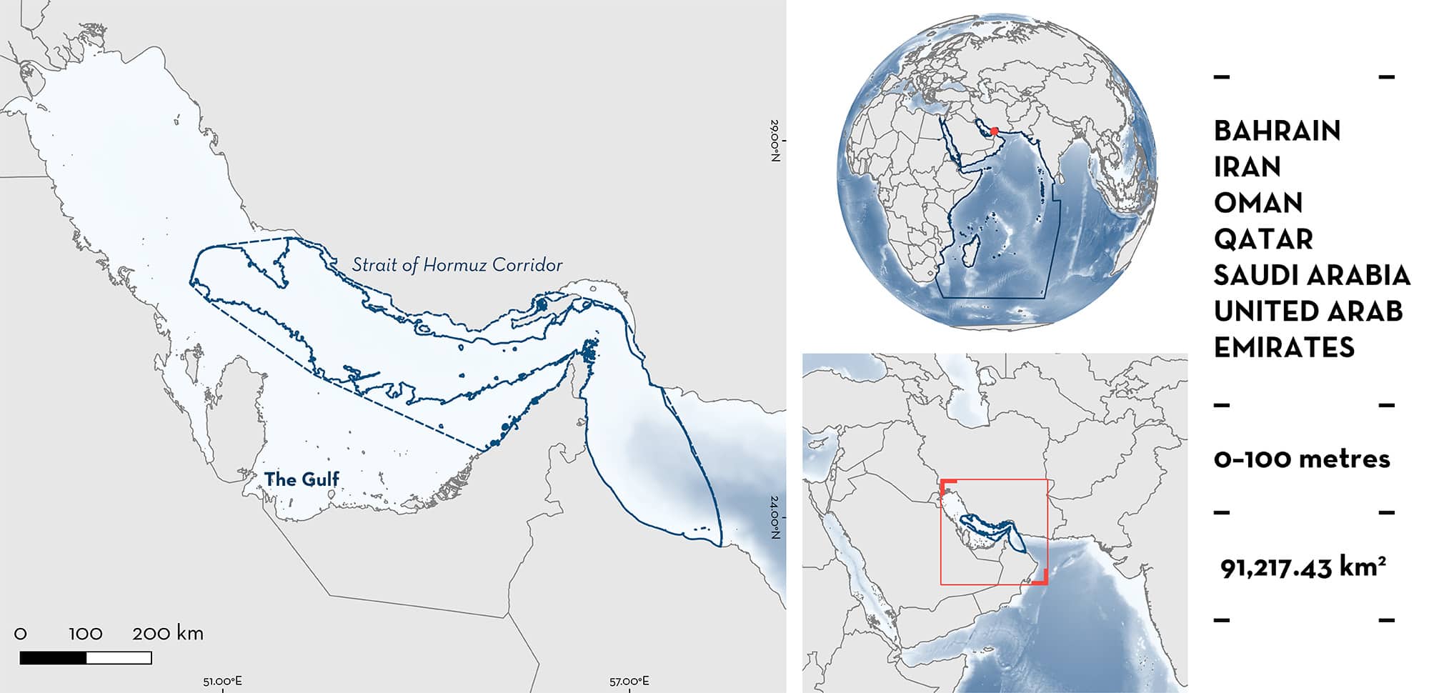
Strait of Hormuz Corridor spans part of the Arabian/Persian Gulf, across the Strait of Hormuz, and into the Gulf of Oman. The area is relatively shallow, characterised by high variations in environmental conditions. The area overlaps the with several Key Biodiversity Areas and three Ecologically or Biologically Significant Marine Areas. Within this area there are: threatened species and areas important for movement (Whale Shark Rhincodon typus).
Download factsheet
Strait of Hormuz Corridor
DESCRIPTION OF HABITAT
Strait of Hormuz Corridor spans part of the Arabian/Persian Gulf (hereafter referred to as ‘The Gulf’), extending across the Strait of Hormuz and into the Gulf of Oman. The area is relatively shallow, characterised by high variations in environmental conditions (Sheppard et al. 2010). The maximum depth of the Gulf is 120 m near the Strait of Hormuz, with an average depth of 40 m (Pous et al. 2015). There is low water exchange between the Gulf and Gulf of Oman. The salinity in the Gulf is higher than in the Indian Ocean due to high levels of evaporation, with currents supplying lower salinity waters across the Strait of Hormuz (Pous et al. 2015). The area is home to numerous islands.
The area overlaps with three Key Biodiversity Areas (KBAs): Daymaniyat Islands (KBA 2023a), Faror Islands (KBA 2023b), and Musandam Islands (KBA 2023c). The area also overlaps with three Ecologically or Biologically Significant Marine Areas (EBSAs): Arabian Sea Oxygen Minimum Zone (CBD 2023a), Daymaniyat Islands (CBD 2023b), and Qeshm Island and Adjacent Marine and Coastal Areas (CBD 2023c).
This Important Shark and Ray Area is pelagic and is delineated from inshore and surface waters (0 m) to 100 m based on the bathymetry of the area and the depth use of the Qualifying Species.
CRITERION A
VULNERABILITY
The one Qualifying Species within the area is considered threatened with extinction according to the IUCN Red List of Threatened SpeciesTM. The Whale Shark is assessed as Endangered (Pierce & Norman 2016).
CRITERION C
SUB-CRITERION C4 – MOVEMENT
Strait of Hormuz Corridor is an important area for the movement of one shark species.
Whale Sharks use the Strait of Hormuz to move between the Gulf and the Gulf of Oman. This movement has been recorded regularly and predictably since 2011, beginning in the boreal summer months when annual feeding aggregations of up to 100 Whale Shark per km2 occur in the Qatari waters of Al Shaheen (Robinson et al. 2013, 2016). In the winter months, Whale Sharks disperse into the Gulf of Oman via the Strait of Hormuz (Robinson et al. 2017).
Between 2011–2014, 59 Whale Sharks were satellite tagged in the Al Shaheen area, and nine individuals subsequently dispersed through the Strait of Hormuz into the Gulf of Oman (Robinson et al. 2017). Additionally, 422 individuals were photo-identified in the Gulf (81% of which were encountered in the Al Shaheen area; Robinson et al. 2016). Thirteen of these individuals were resighted in other locations across this body of water, including into and out of the Gulf through the Strait of Hormuz (Robinson et al. 2016).
Download factsheet
SUBMIT A REQUEST
ISRA SPATIAL LAYER REQUEST
To make a request to download the ISRA Layer in either a GIS compatible Shapefile (.shp) or Google Earth compatible Keyhole Markup Language Zipped file (.kmz) please complete the following form. We will review your request and send the download details to you. We will endeavor to send you the requested files as soon as we can. However, please note that this is not an automated process, and before requests are responded to, they undergo internal review and authorization. As such, requests normally take 5–10 working days to process.
Should you have questions about the data or process, please do not hesitate to contact us.


