ISRA FACTSHEETS
ISRA FACTSHEETS
ASIA REGION
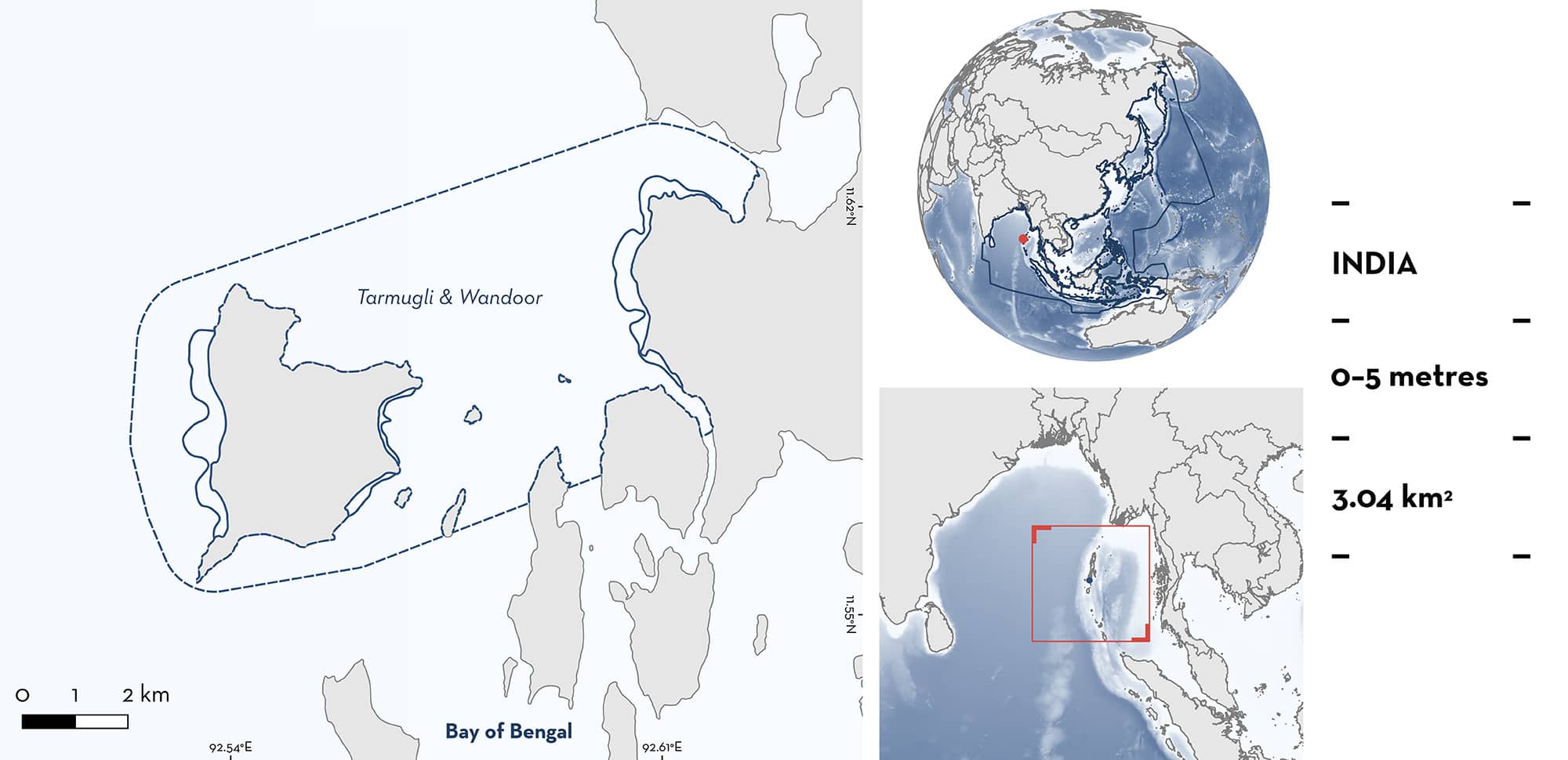
Tarmugli & Wandoor
Summary
Tarmugli & Wandoor is a split area of four shallow coastal sites on southern South Andaman Island in the Andaman and Nicobar Islands, India. These sites have a gentle slope, providing shallow, primarily sandy, habitat which is often sheltered within a bay or by a fringing reef. These sites also have streams that deposit fine sand near the coast and form large sandbanks. Tarmugli & Wandoor overlaps with the Mahatma Gandhi Marine National Park and Key Biodiversity Area. Within the area there are: threatened species and reproductive areas (Giant Guitarfish Glaucostegus typus).
Download factsheet
Tarmugli & Wandoor
DESCRIPTION OF HABITAT
Tarmugli & Wandoor is situated on southern South Andaman Island in the Andaman and Nicobar Islands of India. The archipelago is located ~1,360 km east of mainland India, situated between the Bay of Bengal and the Andaman Sea (Nazareth et al. 2022). It is part of an undersea mountain range that extends from the west coast of Myanmar to the northwest coast of Indonesia. The Andaman Islands comprise over 325 islands, of which 21 are inhabited (Census of India 2011).
These oceanic islands have a limited continental shelf covering ~16,000 km2, and almost no continental slope. They are also part of the Indo-Myanmar and Sundaland biodiversity hotspot (Roberts et al. 2002). They are not only diverse in the biodiversity they support, but also the types of ecosystems and habitats that exist along the coast, with mangroves, coral reefs, seagrass meadows, algal beds, and habitats like creeks, inlets, bays, estuaries, and lagoons. This diversity has led to the islands being highly productive (Ramachandran 2000).
Tarmugli & Wandoor is a split area comprising four sites: Tarmugli West, Tarmugli Southeast, and Tarmugli East, which are on Tarmugli Island, and Wandoor on the western side of South Andaman Island. These sites are in close proximity and display similar habitat characteristics. The sites around Tarmugli Island consist of shallow coastal sites with gentle slopes, providing shallow, primarily sandy, habitats which extend from the shoreline by up to 300 m at some points, and are sheltered within bays or by fringing reefs. All of these sites have streams that deposit fine sand near the coast forming a shallow sandbank. Wandoor also consists of a shallow coastal area with a gentle slope, providing shallow, primarily sandy, habitat which extend out to 400 m at some points. This site is not sheltered within a bay and does not have a prominent fringing reef. A small stream connects to the sea midway along this beach and creates a sandbank along the coastline.
The Andaman and Nicobar Islands receive seven months of rain a year due to the southwest and northeast monsoons which together last from May to December (Patankar 2019).
Tarmugli Islands overlaps with Mahatma Gandhi Marine National Park and Key Biodiversity Area (KBA 2024).
This Important Shark and Ray Area is benthic and is delineated from inshore and surface waters (0 m) to 5 m based on the depth range of Qualifying Species in the area.
CRITERION A
VULNERABILITY
One Qualifying Species within the area is considered threatened with extinction according to the IUCN Red List of Threatened Species. The Giant Guitarfish is assessed as Critically Endangered (Kyne et al. 2019).
CRITERION C
SUB-CRITERION C1 – REPRODUCTIVE AREAS
Tarmugli & Wandoor is an important reproductive area for one ray species.
Local ecological knowledge (LEK) collected between September 2019 and June 2020 from coastal stakeholders (including fishers, coastal residents, dive operators, forest department staff) of the Andaman Islands revealed that early life-stage Giant Guitarfish are utilising the shallow coastal waters of the area (Nazareth et al. 2022). Two respondents had observed early life-stage Giant Guitarfish at the sites around Tarmugli Island, with both reporting daily sightings at these sites. Six respondents had observed early life-stage Giant Guitarfish along the coast of Wandoor and one of these respondents reported seeing them daily.
In addition to LEK, Visual Transect Surveys (VTS) were conducted at sites around Tarmugli Island between June 2023 and January 2024 (E Nazareth unpubl. data 2023–2024). Along 1,000 m transects at each site, a maximum of nine early life-stage Giant Guitarfish were observed at Tarmugli West; a maximum of four at Tarmugli East; and a maximum of three at Tarmugli Southeast. VTS conducted at Wandoor Beach observed a maximum of eight early life-stage Giant Guitarfish along 750 m transects in March 2022 and a maximum of four along 1,000 m transects in May 2023 (E Nazareth unpubl. data 2022–2023). The individuals observed were estimated to be 30–45 cm total length (TL) and were classified as neonates and young-of-the-year based on size-at-birth reported in the literature (35–40 cm TL; Last et al. 2016; Freeman 2019; Gaskins et al. 2020). Tarmugli & Wandoor provides shallow inshore habitat consistent with habitat reported for early life-stage Giant Guitarfish elsewhere (e.g., Freeman 2019; Gaskins et al. 2020).
Download factsheet
SUBMIT A REQUEST
ISRA SPATIAL LAYER REQUEST
To make a request to download the ISRA Layer in either a GIS compatible Shapefile (.shp) or Google Earth compatible Keyhole Markup Language Zipped file (.kmz) please complete the following form. We will review your request and send the download details to you. We will endeavor to send you the requested files as soon as we can. However, please note that this is not an automated process, and before requests are responded to, they undergo internal review and authorization. As such, requests normally take 5–10 working days to process.
Should you have questions about the data or process, please do not hesitate to contact us.


