ISRA FACTSHEETS
ISRA FACTSHEETS
WESTERN INDIAN OCEAN REGION
Umm Al Quwain
Summary
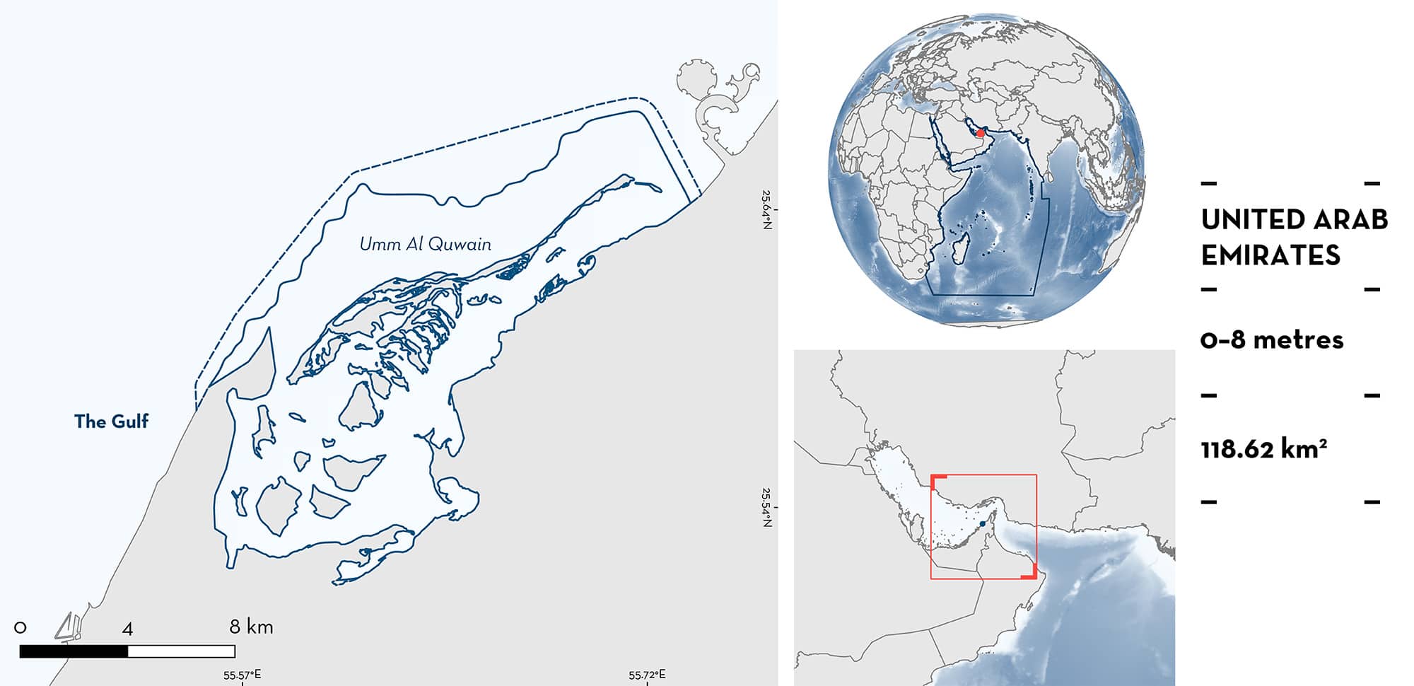
Umm Al Quwain is located in the Arabian/Persian Gulf (hereafter ‘Gulf’), United Arab Emirates. This area is a coastal lagoon with a complex mosaic of interconnected intertidal and subtidal habitats including mangroves, seagrasses, mudflats, and coral reefs. It partly overlaps with the Siniyah and Khor Al Beidah islands Key Biodiversity Area. Within this area, there are: threatened species (e.g., Blacktip Reef Shark Carcharhinus melanopterus); reproductive areas (e.g., Halavi Guitarfish Glaucostegus halavi); and undefined aggregations (Blacktip Reef Shark).
Download factsheet
Umm Al Quwain
DESCRIPTION OF HABITAT
Umm Al Quwain is located in the Arabian/Persian Gulf (hereafter ‘Gulf’), United Arab Emirates. This is a semi-enclosed lagoon separated from the open sea by Siniya Island, a low-lying sand barrier island. Hard and sandy substrates are prominent in the area, including the last remaining coral reefs in the northern United Arab Emirates (Mateos-Molina et al. 2020). This area hosts a complex mosaic of interconnected intertidal and subtidal habitat types including mangroves, mudflats, seagrass beds, saltmarshes, deep dredged channels, and hard substrates colonised with coral, sponges, and algae (Mateos-Molina et al. 2020).
The area overlaps with the Siniyah and Khor Al Beidah islands Key Biodiversity Area (KBA 2023).
This Important Shark and Ray Area is benthopelagic and is delineated from inshore and surface waters (0 m) to 8 m based on the bathymetry of the area.
CRITERION A
VULNERABILITY
Two Qualifying Species considered threatened with extinction according to the IUCN Red List of Threatened SpeciesTM regularly occur in the area. These are the Critically Endangered Halavi Guitarfish (Kyne & Jabado 2019) and the Vulnerable Blacktip Reef Shark (Simpfendorfer et al. 2020).
CRITERION C
SUB-CRITERION C1 – REPRODUCTIVE AREAS
Umm Al Quwain is an important reproductive area for two ray species.
Arabian Banded Whiprays are regularly and predictably sighted in the area. During fieldwork expeditions for breeding birds, this species was observed incidentally in 2014 (n = 4 individuals), 2015 (n = 7 individuals), and 2016 (n = 5 individuals). In 2020, a Baited Remote Underwater Video survey (BRUV) recorded 16 individuals with a frequency of occurrence of 39.1% (Mateos-Molina et al. Submitted). In 2022, another BRUV survey recorded 12 individuals (D Mateos-Molina unpubl. data 2023). In 2015, an aggregation of up to six individuals was observed. Behaviour consisting of chasing, close-following, mounting, and two individuals ‘ventral to ventral’ was also recorded (Whelan et al. 2017; D Mateos-Molina unpubl. data 2023). Bite marks were observed on the rear margin of the pectoral disc (Whelan et al. 2017). Two pregnant females with noticeably distended abdomens were also recorded in the BRUV surveys in 2022 (D Mateos-Molina unpubl. data 2023). This species was not present in other surveyed localities nearby and it appears the area is used due to its shallow, sheltered nature behind sandbars (observed at low tide).
Halavi Guitarfish are regularly and predictably sighted in the area. During fieldwork conducted for breeding birds, individuals (n = 6) were observed incidentally on different days in 2016. In 2020, a drone survey recorded seven individuals with 21% sighting frequency (Mateos-Molina et al. Submitted). In 2022, a BRUV survey recorded 11 individuals (D Mateos-Molina unpubl. data 2023). In incidental reports reported in 2016, four individuals were reported measuring < 30 cm total length (TL), between April and October (Whelan et al. 2017). The size of neonates and young-of-the-year individuals is 30–50 cm TL (Gohar & Mazhar 1964). This species was not present in other surveyed localities nearby and this area is likely used due to its shallow, sheltered nature behind sandbars (observed at low tide).
CRITERION C
SUB-CRITERION C5 – UNDEFINED AGGREGATIONS
Umm Al Quwain is an important area of undefined aggregations for one shark species.
Aggregations of Blacktip Reef Sharks are regularly and predictably sighted between April and June in the shallow waters of the sand bar island that forms the lagoon. Data gathered in 2020 during a workshop where fishers shared their local ecological knowledge, highlighted this aggregation for the first time. Fishers confirmed that this aggregation is regular and predictable during these months since at least a decade. In 2021, the aggregation was incidentally recorded during aerial surveys with a drone (D Mateos-Molina unpubl. data 2023). Further information on the nature and function of these aggregations is required.
Download factsheet
SUBMIT A REQUEST
ISRA SPATIAL LAYER REQUEST
To make a request to download the ISRA Layer in either a GIS compatible Shapefile (.shp) or Google Earth compatible Keyhole Markup Language Zipped file (.kmz) please complete the following form. We will review your request and send the download details to you. We will endeavor to send you the requested files as soon as we can. However, please note that this is not an automated process, and before requests are responded to, they undergo internal review and authorization. As such, requests normally take 5–10 working days to process.
Should you have questions about the data or process, please do not hesitate to contact us.


