ISRA FACTSHEETS
ISRA FACTSHEETS
NEW ZEALAND & PACIFIC ISLANDS REGION
Waialua Bay
Summary
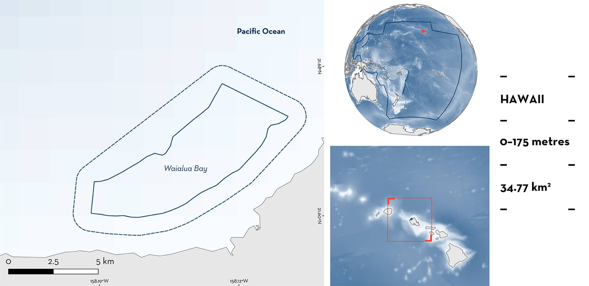
Waialua Bay is located off O’ahu in the Main Hawaiian Islands of the United States of America. The area is offshore and extends from Waimea Point in the northeast to Mokuleia in the southeast. The area is characterised by sandy, muddy, and rubble substrates and is influenced by the North Hawaiian Ridge Current. Within this area there are: threatened species (Sandbar Shark Carcharhinus plumbeus); reproductive areas (Galapagos Shark Carcharhinus galapagensis); and undefined aggregations (e.g., Galapagos Shark).
Download factsheet
Waialua Bay
DESCRIPTION OF HABITAT
Waialua Bay is located off O’ahu in the Main Hawaiian Islands of the United States of America. The area is located offshore and extends from Waimea Point in the northeast to Mokuleia in the southeast. Sandy, muddy, and rubble substrates are the most common habitat features in the area. Easterly trade winds are the main driver of the surface currents in the area and is highly influenced by the North Hawaiian Ridge Current (Costa et al. 2016). During boreal summer, the area is warmer with sea surface temperatures ~26°C, rainfall is low and northeasterly trade winds and trade-wind generated swell dominate the area while in winter temperatures are cooler (~23°C), rainfall is higher, and the area is mostly dominated by the North Pacific Swell that produce high current conditions and upwelling in the area (Costa et al. 2016).
This Important Shark and Ray Area is benthic and pelagic and is delineated from surface waters (0 m) to 175 m based on the bathymetry of the area.
CRITERION A
VULNERABILITY
One Qualifying Species considered threatened with extinction according to the IUCN Red List of Threatened Species regularly occurs in the area. This is the Endangered Sandbar Shark (Rigby et al. 2021).
CRITERION C
SUB-CRITERION C1 – REPRODUCTIVE AREAS
Waialua Bay is an important reproductive area for one shark species.
Between 2015–2024, observations of shark cage diving operations showed the regular presence of female Galapagos Shark with mating scars in the area (J Hartl pers. obs. 2024). Females with heavy scarring, fresh bite marks, and rake wounds (especially between the first and second dorsal fins) are predictably observed every year during summer (July and August) with ~20% of adult females observed having scars (J Hartl pers. obs. 2024). Further, Galapagos Sharks have been observed often displaying pre-mating behaviours (males following females to the point of brushing the lower caudal fin with rostrum) and males displaying perpendicular and flared claspers. Mating behaviour was observed on one occasion, but sharks drifted to depths outside of average human free diving limits (J Hartl pers. obs. 2024).
CRITERION C
SUB-CRITERION C5 – UNDEFINED AGGREGATIONS
Waialua Bay is an important area for undefined aggregations of two shark species.
Data were collated from cage diving operators within the area. While some operators use chumming to attract sharks, direct observations from operators working in the same area that do not use attractors and preliminary results from acoustic telemetry indicate that aggregations of Galapagos Shark and Sandbar Sharks are naturally present in the area (J Hartl. unpubl. data 2024). In addition, both species have been reported in the area since the 1960s in shark control programs (Wetherbee 1996) and despite an expansion of tourist activities in the area, aggregations are still observed.
Shark cage diving operations since 2004 have revealed the regular and predictable presence of aggregations of Galapagos Shark and Sandbar Shark (Meyer et al. 2009; J Hartl unpubl. data 2024). Between January 2004–August 2008 and 2019–2022, cage diving operation logbooks were analysed, and shark aggregations were recorded almost daily (Meyer et al. 2009; J Hartl unpubl. data 2024). Diving operators worked daily with up to six 1–2-hour tours conducted per day. Of 8,495 tours undertaken across 1,545 days between 2004–2008, a total of 109,834 shark observations were recorded and aggregations were observed in almost all the tours conducted (Meyer et al. 2009).
For Galapagos Shark, 81,912 observations (74.6% of all sharks recorded) were recorded between 2004–2008 with aggregations of up to 30 individuals observed in a single tour (median = 13; Meyer et al. 2009). Between 2019–2021, aggregations between 4–20 individuals were observed daily (J Hartl unpubl. data 2024). Galapagos Sharks are most abundant during spring and summer and aggregations are composed of mature and immature individuals from both sexes (Meyer et al. 2009, J Hartl unpubl. data 2024).
For Sandbar Shark, 25,893 observations (23.6% of all sharks recorded) were recorded between 2004–2008 with aggregations of up to 30 individuals observed in a single tour (median = 10; Meyer et al. 2009). Between 2019–2021, aggregations between 3–17 individuals were observed daily (J Hartl unpubl. data 2024). Sandbar Sharks are most abundant during autumn and aggregations are composed almost exclusively by adult males (Meyer et al. 2009, J. Hartl unpubl. data 2024).
More information is needed to understand the function and nature of these aggregations.
Download factsheet
SUBMIT A REQUEST
ISRA SPATIAL LAYER REQUEST
To make a request to download the ISRA Layer in either a GIS compatible Shapefile (.shp) or Google Earth compatible Keyhole Markup Language Zipped file (.kmz) please complete the following form. We will review your request and send the download details to you. We will endeavor to send you the requested files as soon as we can. However, please note that this is not an automated process, and before requests are responded to, they undergo internal review and authorization. As such, requests normally take 5–10 working days to process.
Should you have questions about the data or process, please do not hesitate to contact us.


