ISRA FACTSHEETS
ISRA FACTSHEETS
NEW ZEALAND & PACIFIC ISLANDS REGION
Wake Atoll
Summary
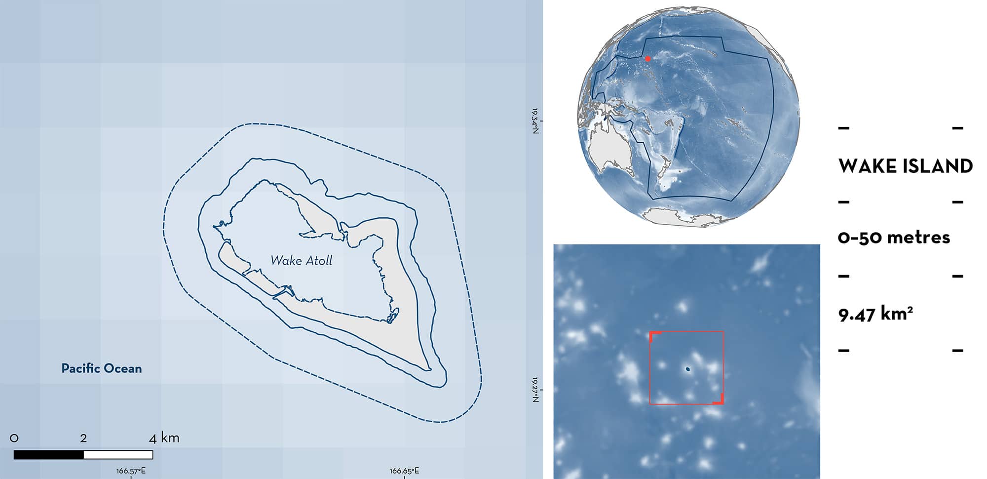
Wake Atoll is an isolated atoll in the West Pacific Ocean. It is governed by the United States of America and is a territory within the United States Minor Outlying Islands. The area is characterised by the presence of three islets (Wake, Peale, and Wilkes) and reefs surrounding a lagoon. The area overlaps with the Wake Island Marine Key Biodiversity Area, with the Wake Atoll National Wildlife Refuge, and with the Pacific Remote Islands Marine National Monument. Within this area there are: threatened species, reproductive areas and undefined aggregations (Grey Reef Shark Carcharhinus amblyrhynchos).
Download factsheet
Wake Atoll
DESCRIPTION OF HABITAT
Wake Atoll is an isolated atoll in the West Pacific Ocean. It is governed by the United States of America and is a territory within the United States Minor Outlying Islands. The atoll is ~560 km from the nearest islands (Marshall Islands) and is composed of three islets (Wake, Peale, and Wilkes) and reefs surrounding a lagoon (Lobel & Lobel 2008, 2018; Brown 2021). The area rests in a submerged mountain with steep slopes and depths that increase quickly relatively close to the shore. The area is characterised by a complex habitat that includes sandy plains and coral reefs subdivided in reef flats, reef crest, forereefs, talus slope, patch reefs, and shallow lagoons (Brown 2021). Sea surface temperatures average 21°C in the boreal winter and 32°C in the summer (Brainard et al. 2019). The western side of the atoll is opened to exchange between the lagoon and oceanic waters, but this exchange seems to be small (Lobel & Lobel 2008). Eddies formed in the western side of Hawaii flow westwards producing connectivity with Wake Atoll (Lobel & Lobel 2008).
The area overlaps with the Wake Island Marine Key Biodiversity Area (KBA 2024). It also overlaps with the Wake Atoll National Wildlife Refuge and the Pacific Remote Islands Marine National Monument (UNEP-WCMC & IUCN 2024).
This Important Shark and Ray Area is pelagic and is delineated from inshore and surface waters (0 m) to 50 m based on the bathymetry of the area.
CRITERION A
VULNERABILITY
One Qualifying Species considered threatened with extinction according to the IUCN Red List of Threatened Species regularly occurs in the area. This is the Endangered Grey Reef Shark (Simpfendorfer et al. 2020).
CRITERION C
SUB-CRITERION C1 – REPRODUCTIVE AREAS
Wake Atoll in an important reproductive area for one shark species.
Diving surveys have indicated that Grey Reef Shark young-of-the-year (YOY) regularly occur in the area (CREP-PIFSC 2017a, 2017b, 2017c; Brainard et al. 2019). Towed dive surveys (undertaken up to 30 m depth and covering ~2.5 linear km in ten five-minute segments; Brainard et al. 2019) conducted in 2005 (October, n = 19 surveys), 2007 (April and May, n = 15), 2009 (March, n = 13), 2011 (March, n = 14), 2014 (March, n = 10), and 2017 (April, n = 9), recorded the presence of YOY Grey Reef Shark (CREP-PIFSC 2017a, 2017b, 2017c; ESD-PIFSC 2019; Brainard et al. 2019). Individuals between 63–85 cm total length (TL) were considered YOY as these sizes are close to the 45–64 cm TL that has been reported as size-at-birth for the species (Ebert et al. 2021). Of the 396 Grey Reef Sharks recorded in these surveys, 46.6% (n = 183) measured ###l###85 cm TL (CREP-PIFSC 2017a, 2017b, 2017c). YOY Grey Reef Sharks were mostly observed in forereefs around the northwestern and eastern parts of the atoll, either as single individuals or in groups up to 20 sharks at depths of 7–23 m (CREP PIFSC 2017a, 2017b, 2017c; Brainard et al. 2019).
CRITERION C
SUB-CRITERION C5 – UNDEFINED AGGREGATIONS
Wake Atoll is an important area for undefined aggregations of one shark species.
Eighty towed diver surveys (undertaken up to 30 m depth and covering ~2.5 linear km in ten five-minute segments; Brainard et al. 2019) conducted between 2005–2017 (recorded the regular presence of juvenile and adult Grey Reef Shark (100–225 cm TL) aggregations (average = 7.3 individuals) in the area (PIFSC 2011; CREP-PIFSC 2017a, 2017b, 2017c; ESD-PIFSC 2019; Brainard et al. 2019). In these surveys, Grey Reef Sharks were observed in 50 of 80 towed dive surveys conducted in the area. Aggregations were recorded in all years except for 2017 and ranged from four to 18 individuals (CREP-PIFSC 2017a, 2017b, 2017c). Between 2004–2010, Johnston Atoll held the fourth largest density (2 individuals/ha) of Grey Reef Sharks in all the US Pacific Ocean (Nadon et al. 2012).
Aggregations of Grey Reef Sharks have been historically reported in the area. Dive surveys (n = 118) conducted in July 1997 and May 1999 found that Grey Reef Sharks occurred regularly in the area (Lobel & Lobel 2004) and formed aggregations (PIFSC 2006). Further, the species was reported as the third most abundant species among all reef fishes in the atoll (PIFSC 2006). Records of washed-up sharks from 2019 (Brown 2021) confirm the contemporary presence of Grey Reef Sharks in Wake Atoll and suggest that aggregations still occur in the area. Additional information is required to determine the nature and function of these aggregations.
Download factsheet
SUBMIT A REQUEST
ISRA SPATIAL LAYER REQUEST
To make a request to download the ISRA Layer in either a GIS compatible Shapefile (.shp) or Google Earth compatible Keyhole Markup Language Zipped file (.kmz) please complete the following form. We will review your request and send the download details to you. We will endeavor to send you the requested files as soon as we can. However, please note that this is not an automated process, and before requests are responded to, they undergo internal review and authorization. As such, requests normally take 5–10 working days to process.
Should you have questions about the data or process, please do not hesitate to contact us.


