ISRA FACTSHEETS
ISRA FACTSHEETS
SOUTH AMERICAN INLAND WATERS
Xingu River
Summary
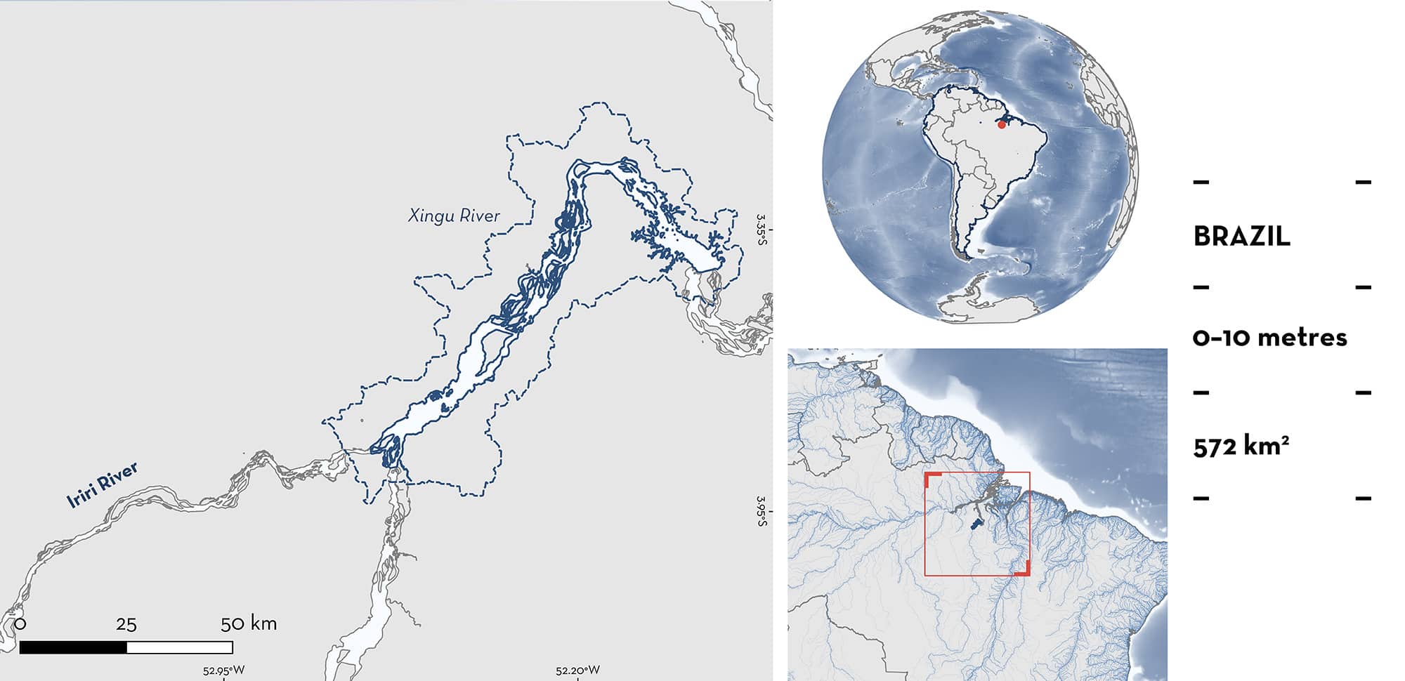
Xingu River is located in the state of Pará in northern Brazil. It is situated in the middle section of the Xingu River, a tributary of the Amazon Basin. This area is characterised by clearwater with low mineral content, low suspended sediment levels, and high transparency. It includes meandering channels, narrow marginal floodplains, sediment bar islands, and seasonally flooded forest islands. This area overlaps with the Baixo Rio Xingu Key Biodiversity Area. Within this area there are: threatened species and reproductive areas (Xingu Freshwater Stingray Potamotrygon leopoldi).
Download factsheet
Xingu River
DESCRIPTION OF HABITAT
Xingu River is located in the middle section of the Xingu River, the fourth largest tributary of the Amazon Basin, in the state of Pará in northern Brazil. This area experiences a tropical climate with an annual temperature of 25–26°C (Charvet-Almeida 2006), with minor changes in surface temperatures throughout the year (Peel et al. 2007). Rainfall is driven by the South American Monsoon System (SAMS), creating a distinct seasonal cycle (Marengo 2004). The dry season is between August–October, while the rainy season peaks between February–April, leading to significant fluctuations in river discharge.
Classified as an oligotrophic and clearwater river, the Xingu River has low mineral content, minimal suspended sediments (5–20 mg/L), and high transparency, draining the weathered areas of the Brazilian Shield. These characteristics support unique ecological conditions distinct from sediment-rich Amazonian rivers (Graca et al. 2025).
The middle course of the Xingu River features meandering channels, narrow marginal floodplains, and seasonally flooded forest islands (Graca et al. 2025). These environments, combined with sediment bypass rapids and waterfalls, contribute to the river’s ecological richness. The basin supports a diverse ichthyofauna, with over 500 species, and is recognised as an area of high endemicity (Abell et al. 2008; Dagosta & de Pinna 2019). Seasonal flooding sustains critical habitats such as rocky rapids, sediment bar islands, and marginal floodplains. The river’s substrates vary widely, with species like the Xingu Freshwater Stingray preferring stone, pebbles, and sand (Charvet-Almeida 2006).
The middle Xingu contains the Amazon Basin’s largest system of rapids, creating a complex mosaic of aquatic habitats that foster high biodiversity and endemism (Graca et al. 2025). The Volta Grande region, known for its rapids and waterfalls, serves as a natural dispersal barrier, contributing to ecological differentiation (Charvet-Almeida 2006). However, an artificial barrier, the Pimental Dam, was constructed ~200 km from the Volta Grande region, accounting for the southern boundary in this area.
This area overlaps with the Baixo Rio Xingu Key Biodiversity Area (KBA 2025).
This Important Shark and Ray Area is benthic and is delineated from surface waters (0 m) to 10 m based on the depth range of Qualifying Species in the area.
CRITERION A
VULNERABILITY
One Qualifying Species considered threatened with extinction according to the IUCN Red List of Threatened Species regularly occurs in the area. This is the Vulnerable Xingu Freshwater Stingray (Charvet et al. 2022).
CRITERION C
SUB-CRITERION C1 – REPRODUCTIVE AREAS
Xingu River is an important reproductive area for one ray species.
Between January 2003–December 2005, 166 Xingu Freshwater Stingrays (81 females, 85 males) were captured using various fishery gears, including longlines, dip nets, hand lines, cast nets, and harpoons (Charvet-Almeida 2006). Xingu Freshwater Stingrays measured between 10.9–70 cm disc width (DW). From the 58 adult females sampled, 50 (86%) were pregnant as determined by the presence of embryos. Further, 54 of the adult males had post-copulation claspers containing semen.
Within this area, the reproductive cycle of Xingu Freshwater Stingrays is closely tied to the hydrological cycle of the Xingu River. Copulation occurs during the transition between the dry and rainy seasons (September–November). Mating is marked by males biting the females’ pectoral fins. Gestation lasts ~5–6 months, spanning the peak of the rainy season and early dry season (December–May). Births mainly occur between May–July, coinciding with the receding water levels as the dry season begins. This timing is likely an adaptive strategy, ensuring that newborn rays are born in more stable and less turbulent conditions (Charvet-Almeida 2006).
The capture of Xingu Freshwater Stingrays was predominantly based on adult individuals (n = 112 accounting for 67.5% of the captures). Sizes captured are likely to have been influenced by the fishing gear used. Sub-adult rays are difficult to capture using longlines and nets, being agile enough to escape the net, but still probably too small to be caught by hooks. Therefore, neonate and young-of-the-year (YOY) individuals might also be present in this area (P Charvet pers. obs. 2025).
In November 2021, 42 Xingu Freshwater Stingrays (22 females, 19 males) were collected using bottom longlines and dip nets during research surveys in this area (Torres et al. 2023). From the 22 females, 12 were adults (42.9–65.3 cm DW) based on an examination of their reproductive organs. Although, the sampling was conducted during the dry season (resting stage of their reproductive cycle), six females were pregnant (presence of embryos). This confirms the contemporary use of this area and its importance for the reproduction of this species.
Download factsheet
SUBMIT A REQUEST
ISRA SPATIAL LAYER REQUEST
To make a request to download the ISRA Layer in either a GIS compatible Shapefile (.shp) or Google Earth compatible Keyhole Markup Language Zipped file (.kmz) please complete the following form. We will review your request and send the download details to you. We will endeavor to send you the requested files as soon as we can. However, please note that this is not an automated process, and before requests are responded to, they undergo internal review and authorization. As such, requests normally take 5–10 working days to process.
Should you have questions about the data or process, please do not hesitate to contact us.


