ISRA FACTSHEETS
ISRA FACTSHEETS
WESTERN INDIAN OCEAN REGION
Zalala Farora
Summary
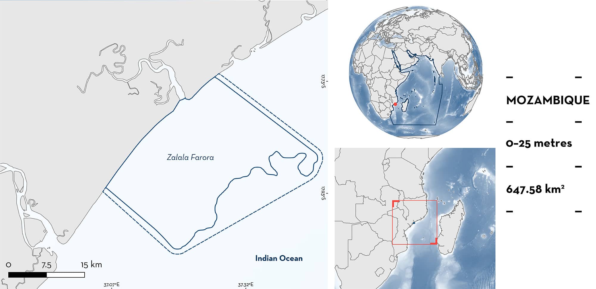
Zalala Farora is located in the northern part of the Sofala Bank, in the Zambezia province of central Mozambique. This area is shallow (<25 m deep) and is mostly characterised by sand and mud substrates. It is near the Zambezi River delta and is influenced by river discharge. It is a highly productive area, also due to the adjacent Angoche upwelling cell, which is responsible for high nutrient input resulting in an abundance of marine species in this area. This coastal site partly overlaps with the Quelimane to Zuni River Ecologically or Biologically Significant Marine Area (EBSA) and lies within the Mozambique Channel EBSA. Within this area there are: threatened species (e.g., Blacktip Shark Carcharhinus limbatus) and reproductive areas (e.g., Scalloped Hammerhead Sphyrna lewini).
Download factsheet
Zalala Farora
DESCRIPTION OF HABITAT
Zalala Farora is situated on the Sofala Bank in central Mozambique. The coastline is characterised by mangrove forests, swampy depressions, a series of low beach ridges, and adjacent islands with coral and rocky substrate. Sand and mud substrate are the most dominant habitat types resulting from the inflow of the Muniga, Molocué, Namacura, and Bons Sinais rivers, as well as other large, regional rivers including the Zambezi, Ligonha, and Licungo rivers. The extensive and well-established mangroves thrive because of the alluvial and freshwater discharge. Freshwater discharge and shelf break upwelling events are the most important source of nutrients which are spread by eddies in the Mozambique Channel (Malauene et al. 2014), leading to high productivity.
Zalala Farora partly overlaps with the Quelimane to Zuni River Ecologically or Biologically Significant Marine Area (EBSA; CBD 2023a) and lies within the Mozambique Channel EBSA (CBD 2023b).
This Important Shark and Ray Area is benthopelagic and is delineated from inshore and surface waters (0 m) to 25 m based on the bathymetry of the area and where the Qualifying Species are caught by fishers.
CRITERION A
VULNERABILITY
Two Qualifying Species considered threatened with extinction according to the IUCN Red List of Threatened SpeciesTM regularly occur in the area. These are the Critically Endangered Scalloped Hammerhead (Rigby et al. 2019) and the Vulnerable Blacktip Shark (Rigby et al. 2021).
CRITERION C
SUB-CRITERION C1 – REPRODUCTIVE AREAS
Zalala Farora is an important reproductive area for two shark species.
Catch records from artisanal fisheries in the area from 2008–2022 indicate that 81% (n = 671) of Scalloped Hammerheads landed and measured in the area were young-of-the-year (YOY; 366 individuals) or neonates (180 individuals), based on body size (Instituto Oceanográfico de Moçambique [InOM] & Wildlife Conservation Society [WCS] unpubl. data 2023; Fernando et al. in prep.). Individuals up to 57 cm total length (TL) were considered neonates and those ranging 57–80 cm TL were classed as YOY (Anislado-Tolentino et al. 2008).
Similar catch records from 2017–2022 indicated that 80% (n = 619) of Blacktip Sharks landed and measured were YOY (360 individuals) or neonates (133 individuals) based on body size (InOM & WCS unpubl. data 2023; Fernando et al. in prep.). Individuals < 60 cm TL were considered neonates and those ranging 60–92 cm TL were classed as YOY (Branstetter 1987).
Pregnant females of both species have been recorded in this area. Studies of the reproductive biology of Blacktip Sharks (n = 484) and Scalloped Hammerheads (n = 235) show that mostly juveniles and pregnant females are landed in the area. There was a seasonal trend, with more pregnant females from April to December for Blacktip Sharks and from September to January for Scalloped Hammerheads, when ~50% of landed individuals from both species were pregnant females.
Artisanal fisheries catch surveys from other provinces in Mozambique suggest that Blacktip Sharks comprised a small proportion of the overall shark and ray landings in these other regions (0.1% in Inhambane, 0.4% in Maputo, 0.3% in Nampula, and 0.6% in Sofala Province) compared to Zambezia province where 98%% of Blacktip Sharks were landed. Similarly, few Scalloped Hammerhead Sharks were landed in other regions (0.1% in Cabo Delgado, 0.2% in Inhambane, 0.3% in Maputo, 1.4% in Nampula, 18% in Sofala Province) compared to Zambezia province (79%) (WCS 2020; InOM & WCS unpubl. data 2023), which highlights the importance of Zalala Farora for these two species in comparison to other regions in Mozambique.
Download factsheet
SUBMIT A REQUEST
ISRA SPATIAL LAYER REQUEST
To make a request to download the ISRA Layer in either a GIS compatible Shapefile (.shp) or Google Earth compatible Keyhole Markup Language Zipped file (.kmz) please complete the following form. We will review your request and send the download details to you. We will endeavor to send you the requested files as soon as we can. However, please note that this is not an automated process, and before requests are responded to, they undergo internal review and authorization. As such, requests normally take 5–10 working days to process.
Should you have questions about the data or process, please do not hesitate to contact us.


