ISRA FACTSHEETS
ISRA FACTSHEETS
NORTH AMERICAN PACIFIC
La Perouse Bank-Juan de Fuca
Summary
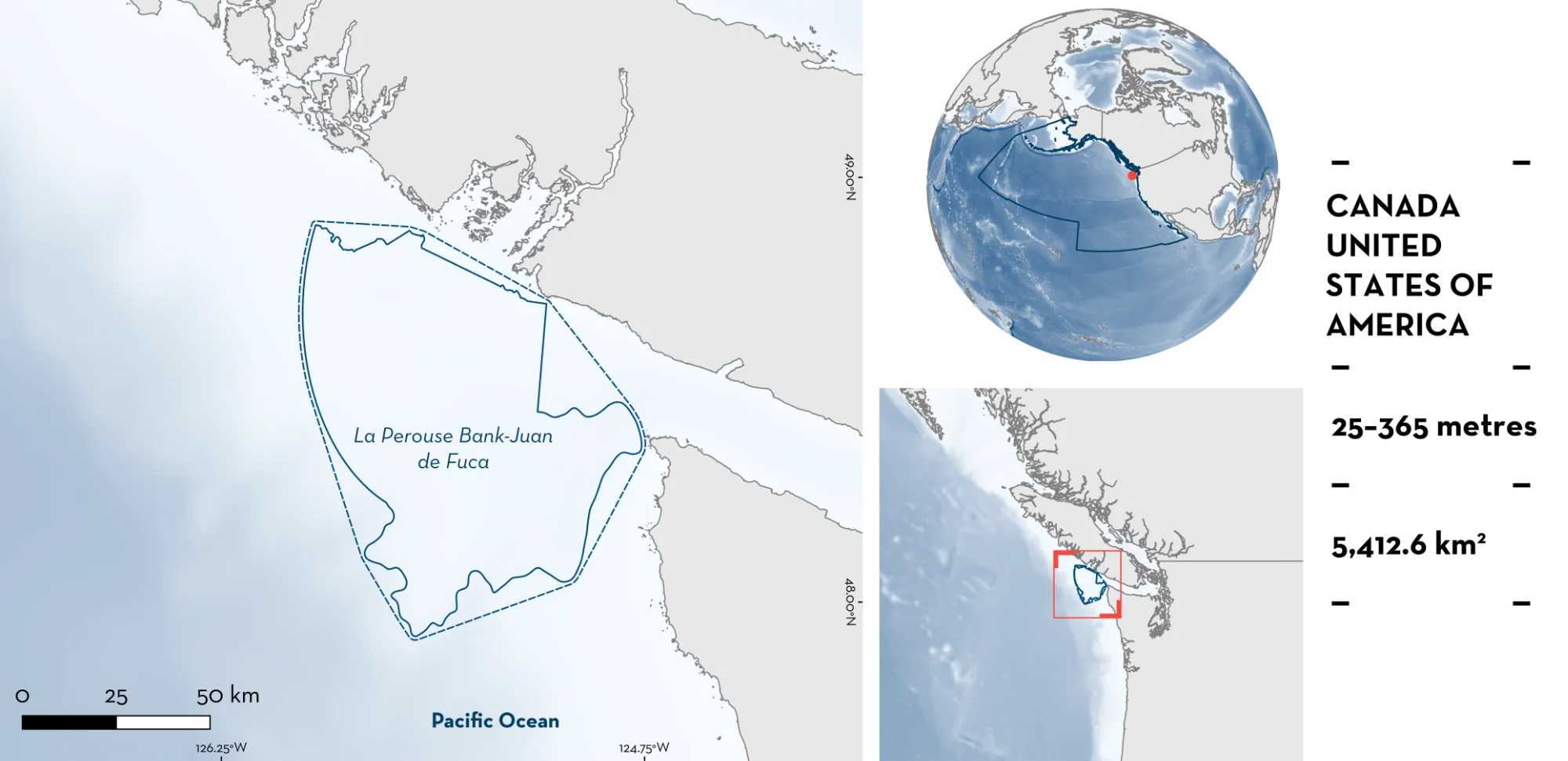
La Perouse Bank-Juan de Fuca is located in the border between Canada and the United States of America. It sits off northwest of Washington state and southwest of Vancouver Island. The area is situated on the narrow continental characterised by boulder and gravel substrates on the inner shelf, transitioning to muddy sands on the outer shelf. The area is influenced by the California Current, Davidson Current, tidal and wind-driven currents and by upwelling promoted by the closeness to the Juan de Fuca canyon. Within this area there are: undefined aggregations (e.g., North Pacific Spiny Dogfish Squalus suckleyi).
Download factsheet
La Perouse Bank-Juan de Fuca
DESCRIPTION OF HABITAT
La Perouse Bank-Juan de Fuca is located in the border between Canada and the United States of America (USA). It sits off Washington state, USA and southeast of Vancouver Island, Canada. The area includes La Perouse Bank which forms part of a smooth continental shelf with bedrock outcrops found on the innermost shelf along with fjord troughs that extend onto the shelf and some areas of irregular terrain resulting from ice margins (Shaw et al. 2024). The substrate comprises boulders and gravel on the inner shelf but transitions to muddy sands on the outer shelf (Bornhold & Giresse 1985). The shelf edge is idented by numerous canyons (Bornhold & Giresse 1985; Burger 2003). The largest of these is the Juan de Fuca, which acts as a conduit for coastal sediments to reach the deep seafloor and promotes upwelling by channeling deep, cold, nutrient-rich waters to the surface (Alford & MacCready 2014). Sediments are predominantly glacial deposits from the Ice Age, with additional modern inputs from the Columbia and Chehalis rivers (Thomson 1981).
The area is influenced by high wave and current energy on the inner shelf (Bornhold & Giresse 1985). The California Current intensifies in the boreal summer, is mainly southward flowing, but is deflected seaward in late autumn by the Davidson Current which is north-westerly flowing (Bornhold & Giresse 1985). During the boreal summer, a large cyclonic (anti-clockwise) eddy develops over this area enhancing the upwelling of deep waters. This process is reinforced by wind-driven upwelling over the shelf, where prevailing northwest winds, combined with the Coriolis effect, transport surface waters offshore and generate plumes of cold, upwelled water extending seaward from the inner shelf (Thomson 1981; Freeland 1992). In contrast, during winter, prevailing southeast winds push surface waters shoreward, reducing offshore transport and suppressing upwelling over the inner shelf (Thomson 1981; Freeland 1992).
This Important Shark and Ray Area is benthic and pelagic and subsurface and is delineated from 25–365 m based on the depth range of Qualifying Species in the area.
CRITERION C
SUB-CRITERION C5 – UNDEFINED AGGREGATIONS
La Perouse Bank-Juan de Fuca is an important area for undefined aggregations of one shark and one chimaera species.
The West Coast Groundfish Bottom Trawl Survey (WCGBTS) is conducted annually between May –July and August–October along the USA west coast between the USA-Canada border and the USA-Mexico border, at depths ranging from 55 to 1,280 m (Keller et al. 2017). The survey area is subdivided into ~12,000 equal-area grid cells, from which 188 cells are randomly selected each year within depth and latitudinal strata to ensure representative spatial sampling. All sharks captured are sorted to species level (or the lowest possible taxonomic resolution) and weighed, and subsamples of selected species are measured. The trawl net used in the survey has a headrope measuring 25.9 m and a footrope measuring 31.7 m. Trawling is conducted during daylight hours at a target speed of 2.2 ± 0.5 knots, with a standard tow duration of 15 minutes (approximately 0.55 km) (Keller et al. 2017). Between 2011–2025, 8,338 tows were conducted in the entire survey area, of which 184 were within this area (2.2%) (NOAA NWFSC FRAM 2026). In addition, between 1998–2025, the International Pacific Halibut Commission (IPHC) conducted annual longline surveys during summer (May–September) across nearshore and offshore waters from Southern California to Alaskan waters (Gulf of Alaska, Aleutian Islands, and the Bering Sea; IPHC 2026a). Surveys were conducted at ~1,200 stations each year primarily at depths of 15–503 m. Longlines consisted of 4–8 skates (longline units) with 96–104 hooks per skate, with soak times between 5–24 hours (IPHC 2026b). Non-halibut species were counted either as subsample counts (20% observations, the majority for sharks) and whole-set counts (100% observations). The average (± standard deviation) number of hooks per set across the surveys was 643 ± 119, while the number of hooks observed per set (i.e., where bycatch was recorded) was 207 ± 120. Nominal catch-per-unit-effort (CPUE) was estimated as the number of individuals caught per 100 hooks per hour.
North Pacific Spiny Dogfish were captured in 1,667 tows in the entire trawled survey area (20% of total tows) at depths between 59–553 m, with 155 tows in this area (84.2% of tows in this area) at depths between 95–362 m. Of the ten highest catch-per-unit-effort (CPUE; number of individuals per square kilometre; ind/km2) along the coast, five are within this area ranging 121,947–1,726,906 (average = 653,349) while the remaining five are at least 60 km apart. The average CPUE for the remaining 150 tows with North Pacific Spiny Dogfish in this area was 2,131.3 ind/km2 (maximum = 55,203 ind/km2). Outside this area, the average CPUE of the remaining 1,607 tows with North Pacific Spiny Dogfish (also not considering the five highest values) is 83 ind/km2 (maximum = 57,192.0 ind/km2). The average maximum number of individuals in a single tow that had North Pacific Spiny Dogfish captured in this area was 317.8, while outside this area it was 23 for the same average area (0.02 km2) (NOAA NWFSC FRAM 2026).
Across the IPHC surveys, North Pacific Spiny Dogfish were recorded in 15,525 longline sets, 490 (3.2%) of which were recorded inside this area in May–July at depths of 25–300 m (IPHC 2026a). For this species, individuals were counted in subsamples (20% of the observations) in 12,132 sets (78.1% of total). The highest mean CPUE of North Pacific Spiny Dogfish in the region (Southern California to Alaska) was reported from this area (mean = 1.77 individuals/100 hooks/hour; 0.01–9.47) compared to adjacent areas in the region (mean CPUE outside the area = 0.38 individuals/100 hooks/hour; 0.007–13.3). Captures of multiple individuals (>10) were recorded in 457 sets (93.3% of the sets with the species captured inside this area), with 534 individuals being the maximum number recorded in a single set (mean 122.0 individuals/set).
Data from trawl surveys comprised the number of individuals and total kilograms per species in each tow, and the total length (TL) was calculated based on the length-weight relationship using parameters available on FishBase (Froese et al. 2013; Froese & Pauly 2026). Neonate/young-of-the-year (YOY) were inferred from sizes estimated from weight measurements. The average size of individuals in tows outside this area ranged 33.6–191.9 cm TL, while in this area ranged 37.5–107.4 cm TL. Size-at-birth for the species is 22–33 cm TL indicating that aggregations were not mainly composed by neonates. Of the 155 tows with North Pacific Spiny Dogfish in this area, 135 had the average size of individuals >48 cm TL. North Pacific Spiny Dogfish are known to form large aggregations of pregnant females and related to seasonal increases in abundance of prey species (Beamish et al. 1992; Ebert et al. 2021). A study using hydroacoustic proxies of prey availability for seabirds in the region also reported aggregations of Squalus spp. in this area (Burger 2003).
Whitespotted Chimaera was captured in 4,429 tows in the entire trawled survey area (53.1% of total tows) at depths between 2–959 m, with 170 in this area (92.4% of tows in this area) at depths between 67–362 m. Based on Kernel Utilization Distribution (KUD) weighted by CPUE (number of individuals per square kilometre; ind/km2), this area is one of the only four areas with KUD >75% along the USA West Coast. Of the 10 highest CPUE along the coast (ranging 68,455.7–252,718.3 ind/km2), two are within this area (188,248.7 and 118,342.7 ind/km2). The average CPUE for the remaining 168 tows with Whitespotted Chimaera in this area was 4,238.7 ind/km2 (maximum = 49,513.6 ind/km2). Outside this area, the average CPUE of the remaining 4,322 tows with Whitespotted Chimaera (also not considering the eight highest values) is 1,240.8 ind/km2. The average maximum number of individuals in a single tow that had Whitespotted Chimaera capture in this area was 96.5, while outside this area it was 22.8 for the same average area (0.02 km2) (NOAA NWFSC FRAM 2026).
Data comprised the number of individuals and total kilograms per species in each tow, and the Precaudal Length (PCL) was calculated based on the length-weight relationship (King & McPhie 2013). The average size of individuals in tows outside this area ranged 6.3–106.1 cm PCL, while in this area ranged 8.7–59.3 cm PCL. Size-at-maturity for the species is 30.2 cm PCL for males and 39.3 cm PCL for females (King & McPhie 2013). Of the 170 tows with Whitespotted Chimaera in this area, 153 had the average size of individuals >30.2 cm PCL (90%) and 82 had the average size of individuals >39.3 cm PCL (48.2%) suggesting that aggregations were mainly composed of juveniles, subadults, and adults. Whitespotted Chimaera are known to form large aggregations that can be size-specific (Barnett et al. 2009).
Further information is required to understand the nature and function of these aggregations.
Download factsheet
SUBMIT A REQUEST
ISRA SPATIAL LAYER REQUEST
To make a request to download the ISRA Layer in either a GIS compatible Shapefile (.shp) or Google Earth compatible Keyhole Markup Language Zipped file (.kmz) please complete the following form. We will review your request and send the download details to you. We will endeavor to send you the requested files as soon as we can. However, please note that this is not an automated process, and before requests are responded to, they undergo internal review and authorization. As such, requests normally take 5–10 working days to process.
Should you have questions about the data or process, please do not hesitate to contact us.