ISRA FACTSHEETS
ISRA FACTSHEETS
NEW ZEALAND & PACIFIC ISLANDS REGION
Kahe Point
Summary
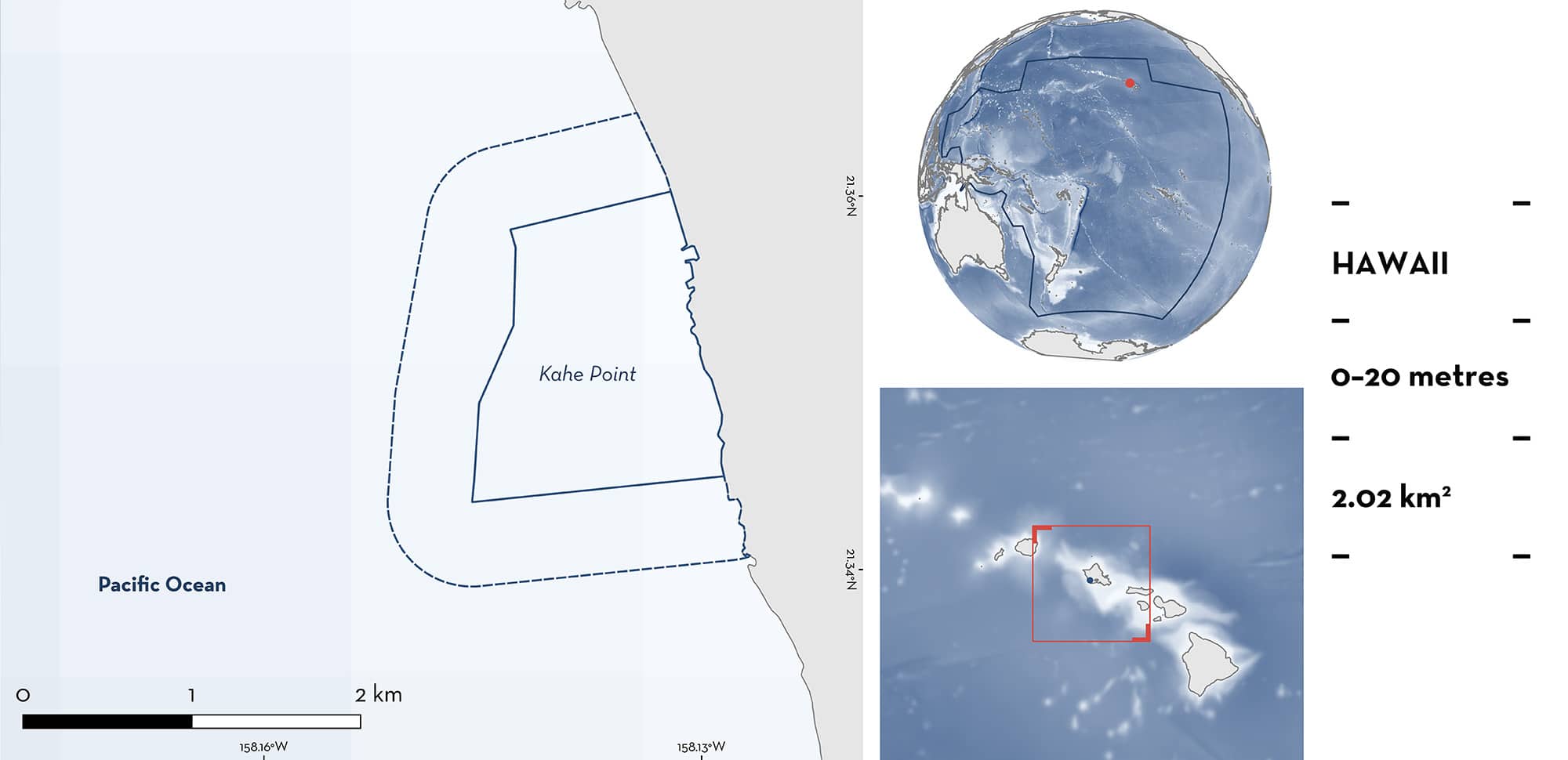
Kahe Point is located on the western coast of O‘ahu, in the Hawaiian Islands of the United States of America. The area covers diverse marine habitats, which include fringing coral reefs, sandy substrates, and rocky outcrops. The oceanography of Kahe Point is influenced by tidal currents and localised warm water outflows, creating conditions that enhance local productivity. Within this area there are: threatened species, feeding areas, and distinctive attributes (Reef Manta Ray Mobula alfredi).
Download factsheet
Kahe Point
DESCRIPTION OF HABITAT
Kahe Point is located on the western coast of O‘ahu, in the Hawaiian Island of the United States of America. The area encompasses coastal and marine environments, covering diverse marine habitats including fringing coral reefs, sandy substrates, and rocky outcrops. Kahe Point is characterised by fringing coral reefs that extends seaward from the shoreline, sloping off into sandy benthos (Jokiel 2008). The habitat includes diverse coral species and seagrass patches, which enhance the areas productivity.
Kahe Point is influenced by complex oceanography and tidal currents which enhance local productivity. The interaction of oceanographic processes and the areas structural complexity fosters periodic plankton blooms which support a diverse marine ecosystem. Furthermore, since 1963, there has been a warm water outflow from the nearby Kahe power plant, which brings warm water into the marine environment in the area (Power Technology 2024). Early studies investigating the impacts of this warm water outflow in the area found negative impacts on coral reefs of the area (Jokiel & Coles 1974).
This Important Shark and Ray Area is benthic and pelagic and is delineated from inshore and surface waters (0 m) to 20 m based on the bathymetry of the area.
CRITERION A
VULNERABILITY
One Qualifying Species considered threatened with extinction according to the IUCN Red List of Threatened Species regularly occurs in the area. This is the Vulnerable Reef Manta Ray (Marshall et al. 2022).
CRITERION C
SUB-CRITERION C2 – FEEDING AREAS
Kahe Point is an important feeding area for one ray species.
Between 2021–2024, 54 sightings of Reef Manta Rays were reported from the area (O‘ahu Manta Project unpubl. data 2024), comprising 14.7% of all Reef Manta Ray sightings around O‘ahu during this period (n = 366). Sightings range between 1–5 individuals at a time (average = 2). The majority of observations in the area are of feeding behaviour (67.9%, n = 36), with the unique foraging strategy of bottom feeding observed in 75% of feeding sightings (n = 27). There are additional anecdotal reports of Reef Manta Rays foraging in this area (C Nevels pers. obs. 2024), however, the importance of this area for this species may currently be underestimated owing to low survey effort. Although there is a warm water outflow pipe situated in the area, Reef Manta Rays are observed feeding inshore and either side of this pipe, and not directly in its vicinity. Given the year-round aggregative behaviour of Reef Manta Rays in the area, the warm water pipe is not assumed to drive their aggregation at this location.
From the sporadic survey effort in the area, 15 individuals have been identified using photo identification (O‘ahu Manta Project unpubl. data 2024). This highlights the site fidelity of individuals to the area and the relatively small population resident to O‘ahu, with only 96 individuals identified around the island of O‘ahu since 2004. No records of inter-island connectivity have been documented, despite collaboration between manta ray research projects using genetics and photo identification techniques (Deakos et al. 2011, Whitney et al. 2023, C Nevels pers. obs. 2024). Of the 15 individuals identified in the area, nine of them were confirmed as juvenile, suggesting there is some degree of habitat segregation between age classes, however more information is needed to confirm whether this area is also important for reproduction.
CRITERION D
SUB-CRITERION D1 – DISTINCTIVENESS
Kahe Point is a distinctive area for one ray species.
Reef Manta Rays are reported swimming along the sandy benthos, feeding on emergent zooplankton in the area (O‘ahu Manta Project unpubl. data 2024). When there is more than one individual, they follow each other in a train along the substrate (C Nevels pers. obs 2024). This is a distinctive behaviour both regionally and globally. ‘Bottom feeding’ behaviour has been described as one of eight feeding strategies Reef Manta Rays employ to efficiently consume their zooplankton prey, however, it has been rarely observed at feeding aggregations of this species (Stevens 2016). For example, an investigation into 285 feeding observations at this species’ largest feeding aggregation site in the Maldives did not report bottom feeding observations. Kahe Point is the only known location in the New Zealand and Pacific Islands region where Reef Manta Rays have been documented regularly and predictably displaying this distinctive behaviour.
Download factsheet
SUBMIT A REQUEST
ISRA SPATIAL LAYER REQUEST
To make a request to download the ISRA Layer in either a GIS compatible Shapefile (.shp) or Google Earth compatible Keyhole Markup Language Zipped file (.kmz) please complete the following form. We will review your request and send the download details to you. We will endeavor to send you the requested files as soon as we can. However, please note that this is not an automated process, and before requests are responded to, they undergo internal review and authorization. As such, requests normally take 5–10 working days to process.
Should you have questions about the data or process, please do not hesitate to contact us.


