ISRA FACTSHEETS
ISRA FACTSHEETS
MEDITERRANEAN AND BLACK SEAS REGION
Strait of Gibraltar
Summary
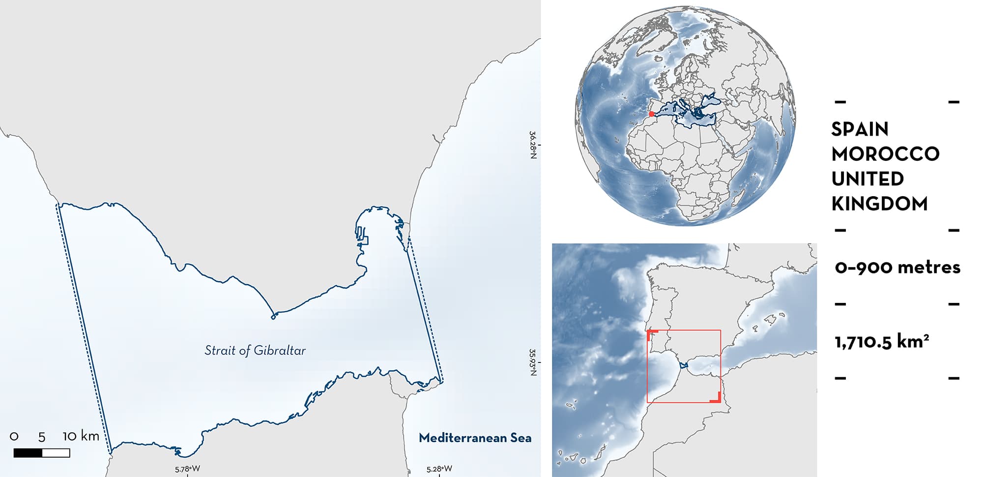
Strait of Gibraltar is the only connection between the Atlantic Ocean and the Mediterranean Sea and separates the Iberian Peninsula of Spain from Morocco. Water flows through the strait from the Atlantic Ocean into the Mediterranean Sea by a surface current, and out of the Mediterranean Sea into the Atlantic Ocean by a deep outflow of water. The area overlaps with one Ecologically or Biologically Significant Marine Area (Gulf of Cadiz) and five Key Biodiversity Areas. Within this area there are: threatened species (e.g., Blue Shark Prionace glauca), and areas important for movement (e.g., Tope Galeorhinus galeus).
Download factsheet
Strait of Gibraltar
DESCRIPTION OF HABITAT
Strait of Gibraltar is a narrow strait which connects the Atlantic Ocean to the Mediterranean Sea and separates the Iberian Peninsula from Morocco. It is 58 km long and 13 km wide at its narrowest. Water flows from the Atlantic Ocean into the Mediterranean Sea by a surface current, and out of the Mediterranean Sea into the Atlantic Ocean by a deep eastward flow of dense, highly saline water (de Stephanis et al. 2008). The two currents interface at a depth of 50–200 m depending on location and tidal flow (de Stephanis et al. 2008). The shallowest part of the trough is the Camarinal sill (~300 m deep) on the western side of the strait and is the location of intense internal wave events which create ‘boiling waters’ at the surface during the maximum outward flow stage of the tidal current (Bruno et al. 2002).
The area overlaps with one Ecologically or Biologically Significant Marine Area (Gulf of Cadiz; CBD 2023), five Key Biodiversity Areas (KBAs; Estrecho de Gibraltar, Tarifa, Ceuta, Strait of Gibraltar, and Jbel Moussa; KBA 2007, 2011a, 2011b, 2011c, 2017), six Natura 2000 sites under the Habitats and/or Birds Directive (ES6120017, ES6120008, ES6310002, ES6120032, ES0000337, ES6120033), and one Ramsar site (Littoral de Jbel Moussa, also a UNESCO Biosphere Reserve and Natural Park).
This Important Shark and Ray Area is pelagic and is delineated from surface waters (0 m) to a depth of 900 m based on the bathymetry of the area.
CRITERION A
VULNERABILITY
There are two Qualifying Species considered threatened with extinction according to the IUCN Red List of Threatened SpeciesTM. These are the Critically Endangered Blue Shark (Sims et al. 2016) and the Critically Endangered Tope (Walker et al. 2020).
CRITERION C
SUB-CRITERION C4 – MOVEMENT
Strait of Gibraltar is an important area for the movement of two shark species. As the ‘Gateway to the Mediterranean’, the strait is the only way in and out of the basin for many migratory species including sharks.
Tag-recapture data of Blue Sharks indicates that the species uses the strait to move between the Atlantic Ocean and the Mediterranean Sea. Between 1972–1975, one shark tagged in Portugal was recaptured 644 days later off the coast of Algeria (Stevens 1976). Between 1970–2001, records from the Irish Central Fisheries Board’s Marine Sportfish Tagging Programme showed two individuals, tagged in Ireland, were recaptured in the Mediterranean Sea after more than 6 months at liberty (Fitzmaurice et al. 2005). Additionally, in 1978, 1986, 2006, and 2011, four Blue Sharks tagged by the US National Marine Fisheries Service (NMFS) Cooperative Shark Tagging Program (CSTP) in the North Atlantic were recaptured in the Mediterranean Sea, in 1978, 1986, 2006, and 2012, respectively (Kohler et al. 2002; J. Carlson pers. comm. 2023). One individual tagged in May 1999 in the Mediterranean Sea was recaptured over a year later in the Atlantic in June 2000 (Kohler et al. 2002; J. Carlson pers. comm. 2023).
Of 64 Tope tagged and released by the Glasgow Museum between 1974 and 1980 in the UK, 12 were recaptured including one off the coast of Algeria in the Mediterranean Sea (Little 1995). Two female Tope tagged in Scotland in 2009 and in Ireland in 2015 were subsequently recaptured off the south coast of Sicily in 2014 and 2017, respectively (Colloca et al. 2019; Thorburn et al. 2019).
The recapture of Blue Shark and Tope individuals on either side of the Strait, as well as direct observations of these and many other species of sharks in the strait, provides strong evidence for the importance of the strait of Gibraltar as a movement channel in and out of the Mediterranean Sea.
Download factsheet
SUBMIT A REQUEST
ISRA SPATIAL LAYER REQUEST
To make a request to download the ISRA Layer in either a GIS compatible Shapefile (.shp) or Google Earth compatible Keyhole Markup Language Zipped file (.kmz) please complete the following form. We will review your request and send the download details to you. We will endeavor to send you the requested files as soon as we can. However, please note that this is not an automated process, and before requests are responded to, they undergo internal review and authorization. As such, requests normally take 5–10 working days to process.
Should you have questions about the data or process, please do not hesitate to contact us.


