ISRA FACTSHEETS
ISRA FACTSHEETS
ASIA REGION
Singkep-Lingga
Summary
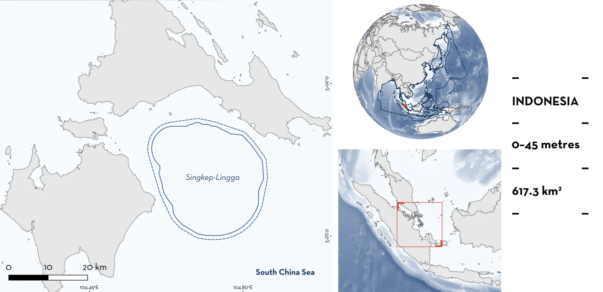
Singkep-Lingga is located east of Sumatra, Indonesia. The area encompasses waters between the islands of Singkep and Lingga. The habitat is characterised by sandy or muddy substrates with extensive areas of coral reef. The area is influenced by both the Northeast and Southwest monsoon currents with high productivity and regular upwelling. Within this area there are: threatened species and range-restricted species (Clown Wedgefish Rhynchobatus cooki).
Download factsheet
Singkep-Lingga
DESCRIPTION OF HABITAT
Singkep-Lingga is located east of Sumatra, Indonesia. It is situated on the Straits of Malacca (a funnel-shaped channel between the Malaysian Peninsula and eastern coast of Sumatra) and the Sunda Shelf within the Sundaland paleo-drainage system (an ancient river system in Southeast Asia when sea levels were lower), a major biodiversity hotspot with high endemism (Cheng & Faidi 2025; Ai et al. 2025). The area encompasses waters between the islands of Singkep and Lingga. The habitat is characterised by sandy or muddy substrates with extensive areas of coral reef (Aryanto et al. 2014). Coastlines of the adjacent islands consist of sandy beaches, mudflats, mangroves, patches of rocky shoreline, and estuarine environments (Aryanto et al. 2014).
The area is influenced by a monsoonal climate and tropical oceanographic processes driven by the mixing of the Java Sea, Straits of Malacca, and South China Sea (Tay et al. 2016). The waters are influenced by both the Northeast and Southwest monsoon currents, which circulate within the Andaman Sea, the Sunda Shelf, and the South China Sea (Ai et al. 2025). The area is highly productive year-round, with elevated chlorophyll-a concentrations and relatively low sea surface temperatures (SST), with regular upwelling in the region (Putra et al. 2021).
This Important Shark and Ray Area is benthic and is delineated from inshore and surface waters (0 m) t0 45 m based on the bathymetry of the area.
CRITERION A
VULNERABILITY
One Qualifying Species considered threatened with extinction according to the IUCN Red List of Threatened Species regularly occurs in the area. This is the Critically Endangered Clown Wedgefish (Kyne et al. 2019).
CRITERION B
RANGE RESTRICTED
This area holds the regular presence of Clown Wedgefish as a resident range-restricted species.
Social media posts, fisheries monitoring, and fisher knowledge has shown that Singkep-Lingga is one of only two areas where Clown Wedgefish have been recorded in the wild (the other being Bengkalis, Merbau, and Rangsang islands along the eastern coast of Sumatra). Between 2015–2020, seven records of Clown Wedgefish were posted on social media by local fishers from Singkep Island (n = 6) and Lingga Island (n = 1), both adjacent to the area (McDavitt & Kyne 2020). These posts revealed that these animals were caught locally in small-scale fisheries (McDavitt & Kyne 2020). Between 2021–2023, additional landings of Clown Wedgefish were recorded on Singkep Island again from fishers posting on social media (n = 4; McDavitt & Simeon 2024).
Between 2022–2026, a dedicated project focused on documenting local landings of the species in Singkep-Lingga, as well as Bengkalis and Rangsang islands (outside of this area) through fisheries monitoring (BM Simeon et al. unpubl. data 2022–2026). A total of 16 specimens were documented from Singkep-Lingga across this period (2024, n = 6; 2025, n = 9; 2026, n = 1) (BM Simeon et al. unpubl. data 2022–2026). This included pregnant females (n = 2) and neonates (n = 4) suggesting that the area is likely important for reproduction. To understand exactly where the species was being caught, semi-structured interviews were conducted on Singkep Island (n = 19 interviewed fishers) and Lingga Island (n = 10) in 2023–2024 (BM Simeon et al. unpubl. data 2023–2024). Fishers consistently identified this area as the fishing grounds where they encounter Clown Wedgefish (BM Simeon et al. unpubl. data 2023–2024).
Clown Wedgefish are restricted to the South China Sea Large Marine Ecosystem.
Download factsheet
SUBMIT A REQUEST
ISRA SPATIAL LAYER REQUEST
To make a request to download the ISRA Layer in either a GIS compatible Shapefile (.shp) or Google Earth compatible Keyhole Markup Language Zipped file (.kmz) please complete the following form. We will review your request and send the download details to you. We will endeavor to send you the requested files as soon as we can. However, please note that this is not an automated process, and before requests are responded to, they undergo internal review and authorization. As such, requests normally take 5–10 working days to process.
Should you have questions about the data or process, please do not hesitate to contact us.